Wilson Pimple
Red Rock Canyon N.C.A. - Nv.
Overview:
Wilson Pimple (aka Potato Knoll) is located in Red Rock Canyon National Conservation Area which is administered by the Bureau of Land Management (BLM).
Within Red Rock Canyon are three "separate" well known and popular areas, the Scenic Loop Drive, Calico Basin and Cottonwood Valley.
The hike to Wilson Pimple is located within the Cottonwood Valley area which measures approx. 10 miles long (N-S) and 1 mile wide (E-W).
Along the valley's Western "border" the Keystone Thrust (aka Wilson Cliff's) is a world famous fault (geologically) and includes more than twenty mountain peaks and associated canyons.
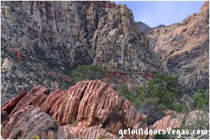
The Wilson Cliffs are made up of red, pink, yellow and tan sandstone that abruptly rise above the relatively flat valley floor, offering extraordinary views from below.
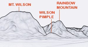
Wilson Pimple itself is a small summit that lies just east of the Wilson Cliff's in the "shadow" of Mt. Wilson.
When compared to the Wilson Cliff's striking dominance over the landscape Wilson Pimple seems a insignificant peak.
However, from Wilson Pimple's summit the views are surprisingly scenic as they spread out across Cottonwood Valley with the east face(s) of Mt. Wilson and the Wilson Cliff's towering above.
Highlights include: lush desert vegetation, a chance to see wildlife, up-close views of the Wilson Cliff's (look for rock climbers) and "relative" solitude.
With many things to see, the area around Wilson Pimple is a great place for exploration.
With exploration in mind, this web-page describes three alternatives to the Wilson Pimple hike: (1) Summit Wilson Pimple - return to trailhead (2) Summit Wilson Pimple - return loop option (3) Wilson Pimple Loop - no summit climb.
In addition, the area around Wilson Pimple is "infested" with use-trails that afford "seemingly endless" hiking opportunities (route finding and terrain awareness skills suggested).
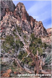
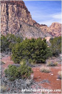
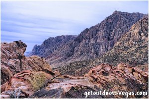
...trailside scenery
Information / Tips:
Bring plenty of water / snacks, hat, sunscreen, sunglasses and hiking boots (recommended).
Make sure you have a full tank of gas and a fully pressurized spare tire.
Dogs are allowed on leash.
DON'T forget your camera.
..........
• South Oak Creek Parking amenities: none
• South Oak Creek Trailhead amenities:
- information kiosk
- vault toilet: located at Red Rock Canyon
Overlook - on NV-159: 2.00 miles+- North
of South Oak Creek Trailhead
• South Oak Creek Trail: not ADA accessible
• Fees: none
• Limited Shade
• No Water Available
..........
nearby: Ash Spring Trail
nearby: Calico Basin - South Trail
nearby: First Creek Canyon Trail
nearby: Red Spring Boardwalk
nearby: Rubber Ducky Tree
nearby: Scenic Loop Drive
Warning:
This adventure involves travel to a relatively remote area, please refer to the section on desert travel for safety information.
• Watch for snakes
• Be mindful of lightning / flash floods
• AVOID THE AREA DURING EXTREME HEAT
• You are responsible for your own safety
Trail Directions:
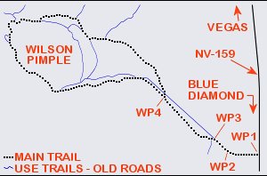
From the trailhead / parking area (WP1) head Westerly along the South Oak Creek Trail (old road) for 0.16 miles+- to an iron gate (WP2) with trail sign, located just beyond the Original Oak Creek Campground.
From WP2 continue Westerly along the old road (cross Red Rock Wash) then Northwesterly to a fork in the old road and WP3, being 0.12 miles+- distant of WP2.
From WP3 an old road (being re-vegetated) continues straight, however bear Left at this fork following an old road that generally parallels the aforementioned re-vegetated road, traveling 0.45 miles+- to yet another fork in the old road and WP4.
From WP4 bear Left continuing along the old road to a point where the aforementioned re-vegetated road rejoins the "trail" and WP5, being 0.19 miles+- distant of WP4.
From WP5 continue in a Westerly direction along the now "rejoined" old roads (ignore old road to immediate right) eventually climbing at a steeper grade to a point where the old road curves sharply Right (Northwesterly) and WP6, being 0.58 miles+- distant of WP5.
From WP6 continue up-slope in a Northwesterly direction (along the old road) traveling 0.13 miles+- to a "trail junction" atop Wilson Saddle and WP7.
Note: at WP7 the South Oak Creek Trail continues "straight ahead" and downslope in a Northwesterly direction, the Wilson Pimple summit area bears Right at this "trail junction".
To continue to the Wilson Pimple summit area, turn Right at WP7 following yet another old road (traverses up-slope) in a more North-Northwesterly direction to and thru a hard-right hand switchback and continue Southeasterly to the midpoint (WP8) of a hard-left hand switchback, being 0.17 miles+- distant of WP7.
From WP8 a very steep (uphill) and rocky use-trail bears Southeasterly, climbing the Westerly slope of Wilson Pimple for 0.05 miles+- to a point (WP9) where the use-trail abruptly turns Left (Northerly).
From WP9 the rocky use-trail continues up-slope in a Northerly direction, traversing across the slope for 0.04 miles+- to a point (WP10) on the Westerly ridgeline of Wilson Pimple.
From WP10 continue cross-country in a Northeasterly direction for 0.03 miles+- to a point (WP11) located in an open, fairly flat sandy area.
From WP11 turn Right (Southeasterly) utilizing a combination of "faint" use-trails, boulder hopping and cross-country travel (up-slope) for 0.07 miles+- to the Wilson Pimple summit area and WP12.
Return by reversing route.
Approx. out and back distance (as described above): 4.0 miles.
Return Loop Option:
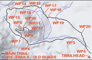
From (or returning to) WP7 (Wilson Saddle) hikers can extend their outing by circling the base of Wilson Pimple (in a clockwise direction).
This "return loop option" travels along the Westerly, Northwesterly and Northerly base of Wilson Pimple, eventually heading Easterly and Southeasterly away from the East face of Wilson Pimple towards the previously visited WP4.
Along this return loop option many use-trails exist, making the route somewhat confusing (see Note below) and nearly impossible to describe.
Therefore, the following route directions provide waypoint positions, distances and generalized descriptions only.
From the aforementioned WP7 continue Northwesterly (downslope) along the South Oak Creek Trail, traveling 0.31 miles+- to a fork in the trail and WP13.
From WP13 bear Right (staying on the South Oak Creek Trail) traveling Northerly (many use-trails in area) for 0.17 miles+- to a "nondescript" trail intersection (easy to miss) and WP14.
From WP14 turn Right meandering in an Easterly direction along a use-trail (many use-trails in area) for 0.20 miles+- to a point where the use-trail intersects Oak Creek Wash (typically dry) and WP15.
From WP15 cross to the North side of the Wash, following the use-trail Easterly and parallel to Oak Creek Wash for 0.21 miles+- to a point (WP16) where the trail recrosses Oak Creek Wash.
From WP16 cross to the South side of the Wash and follow the meandering use-trail in a Southeasterly direction for 0.13 miles+- to a trail intersection and WP17.
From WP17 the trail which becomes more evident (at this point) continues in a Southeasterly direction for 0.08 miles+- to a trail intersection and WP18.
Note: the previously described section (WP7, WP13-WP18) essentially "circles" and "parallels" the Northerly side of Wilson Pimple, at WP18 the route turns Easterly away from Wilson Pimple.
From WP18 turn Left (Easterly) traveling 0.11 miles+- to a trail intersection and WP19.
From WP19 continue straight (Easterly) on a "less defined" (somewhat overgrown) use-trail that soon bears Southeasterly to a point on the trail (WP20), being 0.38 miles+- distant of WP19.
From WP20 continue along the use-trail (old road at this point) in a more Southerly direction for 0.18 miles+- to the previously visited WP4.
From WP4 follow your previously visited route (WP4, WP3, WP2, WP1) back to the South Oak Creek Trailhead and parking area.
See the Trail Summary (below) for route options and associated distances.
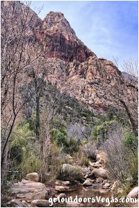
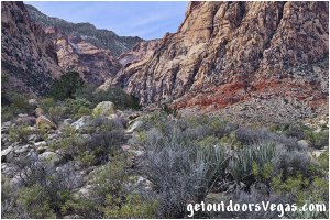
Note: this adventure utilizes "historic" roads, "conventional" trails and use-trails.
Use-trails are sporadic in nature and often "venture out" in all directions.
Within this area of Red Rock Canyon N.C.A. many use-trails exist and can make things "somewhat" confusing.
Therefore, it is recommended to utilize internet mapping resources such as aerial photography (not always current) and the provided waypoint positions (see below) to visualize your route prior to visiting this area.
Following the trail directions as described above, hikers with a map (include aerial photography) can more or less track their position.
However, the Wilson Pimple summit & "Return Loop Option" areas can be troublesome, requiring route finding and terrain awareness skills.
Hikers with less experience should consider traveling with an "qualified" person or group, as this area can be little visited (mid-week).
The use of a handheld GPS unit is suggested for first time visitors, know your GPS device's settings and use.
Don't forget: you are responsible for your own safety.
..........
Trail Summary (as described above):
• Summit Wilson Pimple
(return to trailhead): 4.0 miles+-
• Summit Wilson Pimple
(return loop option): 4.9 miles+-
• Wilson Pimple Loop
(no summit climb): 4.1 miles+-
..........
WP1: N36.08956 W115.44926
trailhead / parking
WP2: N36.08985 W115.45209
trail sign / gate
WP3: N36.09082 W115.45374
trail forks
WP4: N36.09486 W115.45962
trail forks
WP5: N36.09652 W115.46226
trail junction
WP6: N36.09533 W115.47221
trail turns northwesterly
WP7: N36.09667 W115.47379
wilson saddle
WP8: N36.09793 W115.47419
switchback @ use-trail
WP9: N36.09784 W115.47330
use-trail turns northerly
WP10: N36.09833 W115.47331
ridgeline
WP11: N36.09859 W115.47295
flat sandy area
WP12: N36.09787 W115.47208
Wilson Pimple summit area
WP13: N36.09976 W115.47713
trail forks
WP14: N36.10171 W115.47652
trail intersection
WP15: N36.10180 W115.47343
cross creek to North
WP16: N36.10210 W115.47011
cross creek to South
WP17: N36.10088 W115.46890
trail intersection
WP18: N36.10009 W115.46799
trail intersection
WP19: N36.10009 W115.46621
trail intersection
WP20: N36.09733 W115.46061
trail waypoint
Note:
See desert travel for GPS Waypoint info
All distances and waypoints are approximate
Driving Directions:
From the I-15 (Las Vegas Fwy) interchange with W. Flamingo Rd. proceed South on I-15 for 4.5 miles+- to Exit #33.
Exit onto the Exit #33 offramp, traveling 0.4 miles+- (utilizing the right lane) and merge onto westbound Blue Diamond Rd. (NV-160).
Travel Westerly on Blue Diamond Rd. (NV-160) for 10.3 miles+- to the intersection of NV-160 and NV-159.
Turn Right (Northerly) onto NV-159 (aka Blue Diamond Rd.) traveling 6.90 miles+- to the dirt parking area (WP1) for the South Oak Creek Trailhead Parking Area.
Note: the trailhead parking area (located just off the left (West) shoulder of NV-159) lies 1.10 miles+- North of the entrance to Spring Mtn. Ranch State Park.
Return by reversing route.
Approx. 22 miles from central Vegas Strip to the South Oak Creek Trailhead Parking Area.
