Scenic Loop Drive
Red Rock Canyon N.C.A. - Nv.
Overview:

Operated by the Bureau of Land Management, the 195,800+ acre Red Rock Canyon National Conservation Area (Nevada's first conservation area) features fantastic rock formations, narrow canyons, seasonal waterfalls, desert vegetation, wildlife, archaeological sites and much more.
Located just West of the Las Vegas Strip, this extremely popular area is visited by more than two million people each year.
Within Red Rock Canyon are three "separate" well known and popular areas, the Scenic Loop Drive, Calico Basin and Cottonwood Valley.
The Scenic Loop Drive is a 12.3 mile+- one-way "adventure" that passes through arid desert landscapes with colorful sandstone formations and dark limestone cliffs that "tower" above the road, many rising to elevations of 7,000 feet.
The wide paved road (parking allowed only in designated areas) has many scenic pullouts which provide viewpoint parking and opportunities for exploration.
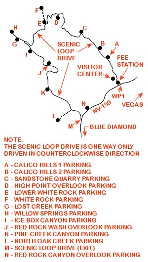
From the highway (NV-159) the Scenic Loop Drive (see map below) runs northerly and uphill paralleling the bright red and buff colored sandstone of the Calico Hills, then loops westerly below the dark gray La Madre Mountain Range (La Madre Mountain Wilderness Area) and finally curves southerly and downhill paralleling the very colorful red, buff and white Wilson Cliffs (Rainbow Mountain Wilderness Area) back to NV-159.
The road provides access to the Red Rock Canyon Visitor Center, the above mentioned Wilderness areas, many scenic pullouts, numerous hikes, rock climbing, picnic areas, grand scenery, a variety of desert vegetation types and a chance to see wildlife.
Red Rock Canyon's Scenic Loop Drive is a fun "adventure" and a "must see destination" when visiting the Las Vegas area.
This spectacular landscape protects cultural sites, wildlife and natural resources while providing many recreational opportunities.
With plenty of sights and hiking opportunities along the way, visitors could easily spend a day (or more) enjoying this spectacular landscape.
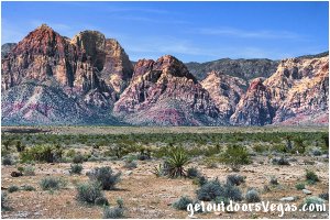
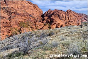
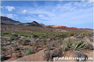
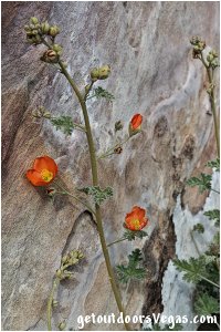
...roadside scenery
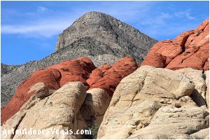
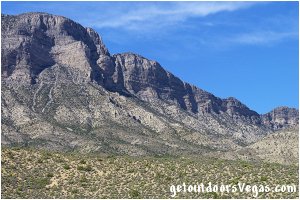
...roadside scenery

Information / Tips:
IMPORTANT: the Scenic Loop Drive is a one-way road, so plan your stops sequentially.
When traveling the Scenic Loop Drive it is recommended to visit each parking lot (even if they seem full, you might get lucky) for each area offers a unique view.
If parking lots are full do not park along the Scenic Loop Drive (parking is only allowed in designated areas).
If a stop is missed visitors must go around the Scenic Loop Drive twice.
Re-entry to the Scenic Loop Drive is allowed with a current day pass.
..........
Bring plenty of water / snacks, hat, sunscreen, sunglasses, comfortable shoes and or hiking boots.
Make sure you have a full tank of gas and a fully pressurized spare tire.
Dogs are allowed on leash.
DON'T forget your camera.
..........
NOTE 1: due to the popularity and proximity of the Red Rock Canyon Scenic Loop Drive to the Las Vegas metropolitan area, it is suggested (if possible) to visit during the week (can be crowded) instead of on a weekend (extremely crowded).
With this in mind plan your visit to fit your schedule, especially when Timed Entry Reservations are in effect as your "preferred" entry time may be already booked.
A suggestion, reserve a date-and-time many days in advance, then adjust your schedule to your reserved time slot (see Note 3 below).
NOTE 2: the Red Rock Canyon Scenic Loop Drive has an entry fee (one day pass).
As of Jan. 2023: cars / trucks are charged $20, motorcycles are charged $10 and a bicycle/rider is charged $8.
Being administered by the Bureau of Land Management (BLM) the Red Rock Canyon N.C.A. accepts federal annual and lifetime passes in lieu of these fees.
NOTE 3: for the Red Rock Canyon Scenic Loop Drive, Timed Entry Reservations are required for vehicle entry to the Scenic Loop Drive between the hours of 8:00am and 5:00pm (Oct 1 thru May 31).
This Timed Entry Reservation requires a $2 fee (not covered by an annual or lifetime pass) in addition to the daily fee for entrance to the Red Rock Canyon Scenic Loop Drive.
For more information and to obtain a Red Rock Canyon Scenic Loop Drive Timed Entry Reservation visit the website www.recreation.gov.
..........
Free Entry Days (dates vary by year):
- M. L. King Jr. Day - mid January**
- President's Day - mid February**
- Natl. Get Outdoors Day - mid June
- Great Amer. Outdoors Day - early August
- Natl. Public Lands Day - late September
- Veterans Day - mid November**
** subject to Timed Entry Requirements
..........
Open every day of the year
Operating Hours (vary by season)
- Nov - Feb: 6:00am - 5:00pm
- Mar & Oct: 6:00am - 7:00pm
- Apr - Sept: 6:00am - 8:00pm
Visitor Center Hours:
- 9:00am - 4:30pm (daily)
..........
nearby: Ash Spring Trail
nearby: Calico Basin - South Trail
nearby: First Creek Canyon Trail
nearby: Red Spring Boardwalk
nearby: Rubber Ducky Tree
nearby: Wilson Pimple
Warning:
This adventure involves travel to a relatively remote area, please refer to the section on desert travel for safety information.
• Watch for snakes
• Be mindful of lightning / flash floods
• AVOID THE AREA DURING EXTREME HEAT
• You are responsible for your own safety
Visitor Center:
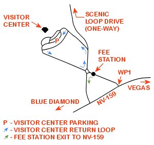
Note: due to the one-way Scenic Loop Drive, visitors wanting to experience the Red Rock Canyon Visitor Center must make this their first stop before proceeding along the Scenic Loop Drive (see map below).
..........
Amenities include:
- beautiful scenery, awesome views
- indoor & outdoor exhibits detailing the
plants, wildlife & geology of the area
- information desk with a very helpful &
well-informed volunteer staff
- small gift shop, restrooms facilities
- water bottle filling fountain
- full ADA accessibility (drop off zone)
- ADA parking (must display placard)
- very large parking area, over-sized
parking available (lower lot)
..........
In addition, the outdoor exhibit area provides an opportunity to explore Red Rock Canyon's very popular Desert Tortoise Habitat.
Established in 1995, the habitat houses several Desert Tortoises (rescued pets) giving visitors a chance to learn about and observe these amazing creatures up-close.
The habitat's Desert Tortoise are typically viewable from April–October and brumate (a form of hibernation) during the remainder of the year.
During the hottest months of the year, they are usually out-and-about in the "relative coolness" of morning.
Note: the Desert Tortoise is the official state reptile of Nevada and is on the endangered species list: being considered a threatened species.
Federal and State Laws are in place to protect the Desert Tortoise, mitigate habitat loss, address disease issues and encourage re-population of the species.
Wild sightings of Desert Tortoise are rare, if encountered consider yourself lucky and observe from a safe, respectful distance.
Scenic Loop Drive:
From the Red Rock Canyon Fee Station immediately bear right along a traffic island (see map above) following signage to the "one-way" Scenic Loop Drive.
Continue onto and along the Scenic Loop Drive to a "Y" intersection being approx. 0.1 miles distant of the Fee Station.
Note: to visit the Red Rock Canyon Visitor Center bear left at this signed "Y" intersection (see aforementioned map to return to the Scenic Loop Drive): to proceed along the Scenic Loop Drive continue straight.
From the "Y" intersection continue on the Scenic Loop Drive (see map above) traveling 1.0 miles+- to a large signed parking lot (Calico Hills 1 - see map below).
This large parking lot (ADA accessible) provides: ample parking (can be very crowded) with dedicated ADA stalls, a restroom facility, trash receptacles, park benches, information kiosks, hiking trailhead and great views.
On exiting the Calico Hills 1 parking area continue on the Scenic Loop Drive for 0.5 miles+- to the Calico Hills 2 parking area.
The Calico Hills 2 parking area is very small, therefore parking can be quite hard to find (recommendation: visit Calico Hills 1 and only stop at Calico Hills 2 if parking is available).
This parking lot (ADA accessible) provides: limited parking with 1 ADA parking stall, a restroom facility, trash receptacle, park benches, information kiosks, hiking trailhead and great views.
From the Calico Hills 2 parking area continue on the Scenic Loop Drive for 1.0 miles+- to the signed turnoff for the Sandstone Quarry parking area (on right).
The Sandstone Quarry parking lot lies 0.1 miles+- North of the Scenic Loop Drive.
This large parking lot (can be extremely crowded) provides: "adequate" parking with ADA parking stalls, a restroom facility, trash receptacle, park benches, information kiosks, hiking trailhead and great views.
On exiting the Sandstone Quarry parking lot continue 0.1 miles+- South back to the Scenic Loop Drive.
Turn Right onto the Scenic Loop Drive traveling 1.9 miles+- to the signed High Point Overlook parking lot (a must stop).
This viewpoint (no restroom facilities) provides: limited parking (can be crowded), information kiosks, park benches and sweeping views of the scenic drive area of Red Rock Canyon.
From the High Point Overlook parking area continue on the Scenic Loop Drive traveling 1.1 miles+- to an intersection with the signed White Rock (Trailhead) Road.
The unpaved White Rock Road (paved for the first 100 feet+-) is a bit rough but drivable (use your own judgment).
There are 2 parking areas "along" this road, the Lower White Rock and the White Rock parking lots, both of which are unpaved.
The Lower White Rock parking area (no restroom facilities), located just North of the Scenic Loop Road, provides: information kiosks, hiking trailhead and nice views.
In fact, many visitors park in this lot and hike up (instead of driving) the White Rock Road to the White Rock parking area and hiking trailhead.
To access the White Rock parking lot, turn Right off the Scenic Loop Drive and proceed along the gravel White Rock Road 0.5 miles+- to the White Rock parking lot.
This signed parking area provides: a restroom facility, information kiosks, hiking trailhead and great views.
Reverse course to return to the Scenic Loop Drive.
Back at the intersection of the Scenic Loop Drive and White Rock Road continue along the Scenic Loop Drive for 1.6 miles+- to the intersection of Willow Springs Road (on Right).
Willow Springs Road is a paved road that runs a total distance of 0.6 miles+- to the Willow Springs Picnic Area and thereafter continues as the "rough gravel" Rocky Gap Road (not described on this web-page).
Turning Right off the Scenic Loop Road onto the Willow Springs Road travel 0.2 miles+- to the Lost Creek parking area.
This parking area provides: limited parking (can be crowded) with ADA stalls, a restroom facility, trash receptacles, information kiosks, hiking trailhead and nice views.
Continue along the Willow Springs Road 0.4 miles+- to the Willow Springs Picnic Area (on your Right) and eventual pavements end.
The area around the Willow Springs Picnic Area provides: ample parking (can be crowded) with ADA stalls, restroom facilities, picnic tables (some ADA accessible), trash receptacles, information kiosks, hiking trailhead, archaeological resources and great views.
Reverse course to return to the Scenic Loop Drive.
Back at the intersection of the Scenic Loop Drive and Willow Springs Road continue along the Scenic Loop Drive for 0.5 miles+- to the signed Ice Box Canyon parking area.
The parking area provides: limited parking (can be crowded) with an ADA stall, a restroom facility, trash receptacle, information kiosk, hiking trailhead and nice views.
From the Ice Box Canyon parking area continue on the Scenic Loop Drive traveling 1.0 miles+- to the signed Red Rock Wash Overlook parking area access road (on Left).
This short paved U-shaped road (one-way - 475 feet+-) provides: limited parking (usually not crowded), short use-trails, a park bench, great views of Red Rock Wash and the Scenic Loop Drive area (no other amenities).
On exiting the Red Rock Wash Overlook parking area continue on the Scenic Loop Drive traveling 1.6 miles+- to the signed Pine Creek Canyon parking area (on Right).
This large parking area provides: ample parking (can be crowded) with ADA stalls, a restroom facility, trash receptacle, information kiosk, hiking trailhead and awesome views.
On exiting the Pine Creek Canyon parking area continue on the Scenic Loop Drive traveling 1.3 miles+- to an intersection with the signed North Oak Creek parking area access road (on Right).
This 0.7 miles+- unpaved access road is a bit rough but drivable (use your own judgment).
At roads end is the North Oak Creek parking area which provides: an adequate number of unmarked parking stalls (can be crowded), a restroom facility, trailhead trash can, information kiosks, hiking trailheads and great views.
Reverse course to return to the Scenic Loop Drive.
Back at the intersection of the Scenic Loop Drive and the North Oak Creek parking area access road, continue along the Scenic Loop Drive for 0.7 miles+- to the end of the Scenic Loop Drive and its intersection with NV-159.
On exiting the Scenic Loop Drive turn Left (Northeasterly) onto NV-159 traveling 0.50 miles+- to the signed turnoff for the Red Rock Canyon Overlook parking area.
The Red Rock Canyon Overlook provides: ample parking (can be crowded) with ADA stalls, a restroom facility, trash receptacles, shaded & uncovered picnic tables, information kiosk, a 1,150 foot+- path to knoll (east of parking area) and a great overview of Red Rock Canyon area.
From the Red Rock Canyon Overlook parking area continue (Northeasterly) on NV-159 traveling 1.70 miles+- to the Red Rock Canyon N.C.A. Visitor Center and Scenic Drive Entrance (WP1 - previously visited).
Continue on NV-159 (Northeasterly) following your earlier route to return to the Las Vegas area.
Note: for an overview of Red Rock Canyon, the Scenic Loop Drive and associated hiking opportunities (map) see: Visitor Guide
WP1: N36.13159 W115.42138
NV-159 & Scenic Loop Drive
Note:
See desert travel for GPS Waypoint info
All distances and waypoints are approximate
Driving Directions:
From the I-15 (Las Vegas Fwy.) interchange with W. Flamingo Rd. proceed South on I-15 (in the right 2 lanes) for 1.3 miles+- and take the off-ramp for County Rd. 215 West (Exit #36).
Continue South on Exit #36 (parallels I-15) following the signs for County Rd. 215 for 1.7 miles+- and take the off-ramp towards County Rd. 215 West.
Continue along the off-ramp for 0.20 miles+- and "bear" Right towards County Rd. 215 West eventually merging onto County Rd. 215 West in approx. 0.50 miles.
Continue on County Rd. 215 West, which transitions into County Rd. 215 North, for a total distance of 12.9 miles+- and take the off-ramp for NV-159 (Exit #26).
Continue along the off-ramp for 0.30 miles+- and turn Left onto NV-159 towards Red Rock Canyon.
Travel 5.30 miles+- on NV-159 to the signed turnoff for the Red Rock Canyon N.C.A. Visitor Center and Scenic Drive Entrance (WP1).
Turn Right and proceed 0.01 miles+- to the Red Rock Canyon Fee Station.
Approximately 22 miles+ from central Vegas Strip to the Red Rock Canyon Scenic Loop Drive Fee Station.
