First Creek Canyon Trail
Red Rock Canyon N.C.A. - Nv.
Overview:
First Creek Canyon, located in Red Rock Canyon National Conservation Area, is administered by the Bureau of Land Management (BLM).
Within Red Rock Canyon are three "separate" well known and popular areas, the Scenic Loop Drive, Calico Basin and Cottonwood Valley.
The First Creek Canyon Trail is located within the Cottonwood Valley area which measures approx. 10 miles long (N-S) and 1 mile wide (E-W).
Along the valley's Western "border" the Keystone Thrust (aka Wilson Cliff's) is a world famous fault (geologically) and includes more than twenty mountain peaks and associated canyons.
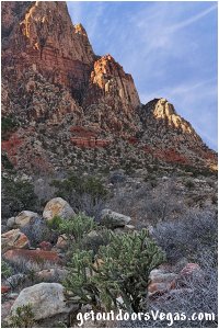
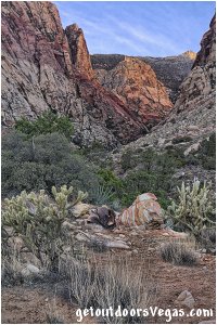
The Wilson Cliffs are made up of red, pink, yellow and tan sandstone that abruptly rise above the relatively flat valley floor, offering extraordinary views from below.
Highlights along the First Creek Canyon Trail include, lush desert vegetation, effects and regeneration of vegetation due to wildfire, possibility of seeing a desert waterfall (typically dry), up-close views of the Wilson Cliff's (look for rock climbers), a chance to see wildlife and "relative" solitude.
The area is surprisingly scenic (with many things to see) and a great place for exploration.
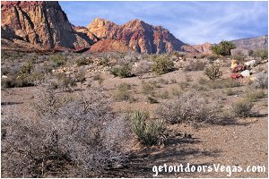
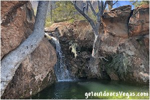
...trailside scenery
Information / Tips:
Bring plenty of water / snacks, hat, sunscreen, sunglasses and hiking boots (advised).
Make sure you have a full tank of gas and a fully pressurized spare tire.
Dogs are allowed on leash.
DON'T forget your camera.
..........
• First Creek Parking amenities: none
• First Creek Trailhead amenities: info. kiosk
(vault toilet: located at Red Rock Canyon
Overlook - on NV-159: 2.50 miles+- North
of First Creek Trailhead)
• First Creek Canyon Trail: not ADA accessible
• Fees: none
• Limited Shade
• No Water Available
..........
nearby: Ash Spring Trail
nearby: Calico Basin - South Trail
nearby: Red Spring Boardwalk
nearby: Rubber Ducky Tree
nearby: Scenic Loop Drive
nearby: Wilson Pimple
Warning:
This adventure involves travel to a relatively remote area, please refer to the section on desert travel for safety information.
• Watch for snakes
• Be mindful of lightning / flash floods
• AVOID THE AREA DURING EXTREME HEAT
• You are responsible for your own safety
Trail Directions:
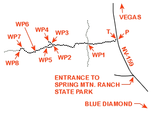
From the trailhead (waypoint T) proceed Southwesterly for 0.02 miles+- and cross Oak Creek Wash (usually dry).
Once across the Wash continue in a Westerly direction for an additional 0.06 miles+- to the Easterly edge of a wildfire area which burned in 2006.
Within the burned area most of the plant life was killed, look for vegetation which is regenerating the area.
Also notice the "staggered" post-and-cable fencing (installed by the BLM) which defines the trail (encourages hikers to stay on trail) while protecting the new vegetation.
Continue Westerly thru the burned area for 0.26 miles+- to the Westerly extent of the burned area which is evident due to unburned vegetation such as Joshua Trees, Mojave Yucca, Creosote Bush and other shrubs.
Once beyond the burned area, continue Westerly for 0.10 miles+- to a trail intersection and WP1 being a total of 0.44 miles+- distant from the trailhead (waypoint T).
Note: at WP1 the Southerly (Left) trail leads to Spring Mtn. Ranch State Park while the trail to the Right (North) connects with trails in the Oak Creek Canyon area to the North.
From WP1 continue Westerly along the First Creek Canyon Trail for approx. 0.55 miles to an unmarked use-trail which leads to First Creek Falls (described below) and WP2.
From WP2 bear Left (West-Southwest) continuing along the First Creek Canyon Trail (thru WP5) for a total distance of 0.31 miles+- to WP6.
From WP6 bear slightly Right (Westerly) traveling along the Southerly bank of First Creek Wash (on use-trails) for 0.23 miles+- to WP7.
From WP7 bear Left (Southwesterly) traveling up-slope (along use-trails) for 0.04 miles+- to a "plateau" area (great views) and WP8 (end of this trail description).
Note: see Trail Note #1 about use-trails.
Return by reversing route.
Approx. out and back distance (as described): 3.14 miles.
Note: see Trail Note #2 for alternate return towards trailhead.
First Creek Falls:
Utilizing use-trails (see Trail Note #1 below), First Creek Falls (typically dry) is a little known (bypassed by most hikers) very picturesque area which is "somewhat" hard to find.
From WP2 bear Right (Northwesterly) up the unmarked use-trail (mentioned above) for 70 feet+- then bear Right (North-Northwesterly) on a "secondary" use-trail to the edge of First Creek Wash and WP3 (located 250 feet+- distant of WP2).
From WP3 head down-slope into the Wash (very loose rock) for 20 feet+- and immediately bear left (contouring upstream) following yet another use-trail (alongside a rock face) for 160 feet+- (eventually descending) to First Creek Falls and WP4.
Return by reversing route.
Approx. out and back distance (as described): 0.16 miles.
Note: to continue along the First Creek Canyon Trail return to WP3 and utilize use-trails that parallel First Creek Wash (upstream) for 440 feet+- eventually merging onto the First Creek Canyon Trail in the vicinity of WP5.
..........
Trail Notes:
(1) This adventure utilizes "conventional" trails and use-trails.
Use-trails are sporadic in nature and often "venture out" in all directions.
Within this area of the Red Rock Canyon N.C.A. many use-trails exist and can make things "somewhat" confusing.
Therefore it is recommended to utilize internet mapping resources such as aerial photography (not always current) and waypoint positions to visualize your route.
(2) Many use-trails exist in this area (WP8) that afford additional exploration (not discussed on this web-page) and alternate route choices (on return) to WP6.
Any route will suffice as the canyon walls "funnel" the use-trails toward WP6 as hikers return toward the trailhead.
..........
P: N36.08133 W115.44794
parking
T: N36.08125 W115.44808
trailhead
WP1: N36.08042 W115.45562
trail junction
WP2: N36.08008 W115.46455
use-trail junction
WP3: N36.08043 W115.46524
trail waypoint - access wash
WP4: N36.08047 W115.46567
First Creek Falls
WP5: N36.07971 W115.46632
use-trail junction
WP6: N36.07876 W115.46920
trail waypoint
WP7: N36.07943 W115.47254
trail waypoint
WP8: N36.07920 W115.47298
turnaround point
Note:
See desert travel for GPS Waypoint info
All distances and waypoints are approximate
Driving Directions:
From the I-15 (Las Vegas Fwy) interchange with W. Flamingo Rd. proceed South on I-15 for 4.5 miles+- to Exit #33.
Exit onto the Exit #33 offramp, traveling 0.4 miles+- (utilizing the right lane) and merge onto westbound Blue Diamond Rd. (NV-160).
Travel Westerly on Blue Diamond Rd. (NV-160) for 10.3 miles+- to the intersection of NV-160 and NV-159.
Turn Right (Northerly) onto NV-159 (aka Blue Diamond Rd.) traveling 6.30 miles +- to the dirt parking area (waypoint P) for the First Creek Canyon Trailhead Parking Area.
Note: the trailhead parking area (located just off the left (West) shoulder of NV-159) lies 0.6 miles+- North of the entrance to Spring Mtn. Ranch State Park.
Return by reversing route.
Approx. 21.5 miles from central Vegas Strip to the First Creek Canyon Trailhead Parking Area.
