Ash Spring Trail
Red Rock Canyon N.C.A. - Nv.
Overview:
The 5,200 acre+- Calico Basin Recreation Area is a popular rock climbing and hiking destination within and on the Easterly edge of the larger Red Rock Canyon National Conservation Area.
Located just West of the Vegas Valley, Calico Basin is a colorful area tucked between the gray limestone of the La Madre Mountains to the North, the red sandstone of the Calico Hills to the West and a desert ridge to the South.
Compared to the surrounding desert, Calico Basin is sheltered and relatively moist with "lush" Mojave Desert Scrub vegetation back-dropped by the sandstone cliffs of the Calico Hills providing a very scenic experience.
The Bureau of Land Management (BLM) manages Red Rock Canyon N.C.A. and is also responsible for the management of the Calico Basin Recreation Area.
However, within Calico Basin lies approx. 200 acres of private holdings (ranch style properties).
Being one of Southern Nevada's most popular outdoor recreation destinations, Calico Basin is experiencing ever increasing visitation as the surrounding urban population and demand for outdoor recreation grows.
In reality, Calico Basin is being "loved to death" which raises many concerns such as resource damage, inadequate infrastructure, parking issues and impacts to homeowners.
At present, Calico Basin has no entry fee or timed entry restrictions, however the BLM is considering implementing a fee / entry system similar to the one in use for the "Scenic Drive" section of Red Rock Canyon.
The Ash Spring trailhead is located at the West end of the Kraft Mountain Parking Area (see driving directions below).
The trail, as described on this web-page, runs along the Ash Creek riparian area up to Ash Spring.
The riparian area which is relatively moist is "heavily" vegetated with trees (eg. Velvet Ash, Fremont's Cottonwood) and grass-like species (sedges & rushes).
Outside the riparian area the "dry" rocky hillsides are typical Mojave Desert Scrub (eg. Creosote Bush, Mojave Yucca).
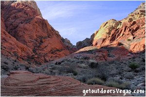
Red sandstone cliffs dominate the area along the upper reaches of Ash Creek and provide awesome views as one progresses up the trail.
Highlights include a beautiful desert Wash, up-close views of the Calico Hills (look for rock climbers) and a chance to see wildlife.
The area is surprisingly scenic (with many things to see) and a great place for exploration.
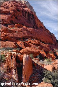
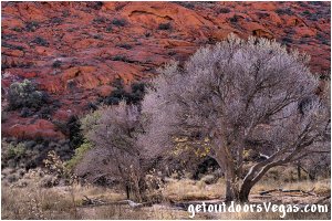
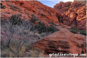
...trailside scenery
Information / Tips:
Note: Just West of the Ash Spring Trailhead (waypoint "T") are a set of informational signs (located on the North side of trail) that direct hikers towards Ash Spring and Kraft Mountain.
The Ash Spring Trail (as described on this web-page) bypasses this "trail intersection" and continues Westerly towards WP2.
It is suggested that hikers refer to Trail Note #1 (see below) if they choose this "alternative" route (not described on this web-page) "out to" or "back from" Ash Spring.
..........
Bring plenty of water / snacks, hat, sunscreen, sunglasses and hiking boots (advised).
Make sure you have a full tank of gas and a fully pressurized spare tire.
Dogs are allowed on leash.
DON'T forget your camera.
..........
• Kraft Mtn. Parking & Trailhead amenities:
information signage only (no other amenities)
vault toilet: located at Red Spring Picnic Area
Note: weekend parking can be problematic
• Ash Spring Trail: not ADA accessible
• Fees: none
• Limited Shade
• No Water Available
..........
nearby: Calico Basin - South Trail
nearby: First Creek Canyon Trail
nearby: Red Spring Boardwalk
nearby: Rubber Ducky Tree
nearby: Scenic Loop Drive
nearby: Wilson Pimple
Warning:
This adventure involves travel to a relatively remote area, please refer to the section on desert travel for safety information.
• Look for wildlife, watch for snakes
• Be mindful of lightning / flash floods
• AVOID THE AREA DURING EXTREME HEAT
• You are responsible for your own safety
Trail Directions:
The Ash Spring trailhead is located at the Westerly end of the Kraft Mountain Parking Area and is "marked" by a set of wooden bollards and cable which prevents further vehicular access.
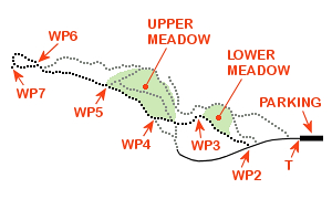
From the trailhead (waypoint "T") the Ash Spring Trail (as described on this web-page) exits the parking area heading Westerly along a wide gravel road (now trail) for 0.10 miles+- to a use-trail which is located just after crossing a Wash and WP2.
From WP2 turn Right (Northwesterly) onto the use-trail which shortly bears Westerly for 0.11 miles+- to WP3.
Note: this section of trail contours along and around a small hill while following the Southwesterly edge of a small meadow.
From WP3 continue Westerly along said trail for 0.08 miles+- eventually reaching the Southerly edge of a second larger meadow and WP4.
From WP4 travel Northwesterly along the Southwesterly edge of this larger meadow for 0.08 miles+- to WP5.
From WP5 continue for a total distance of 0.15 miles+- along the trail (Northwesterly), eventually turning Right (Northerly) on a use-trail (see Trail Note #1 below) which crosses into and along a sparsely vegetated Wash to a red sandstone outcropping at the Westerly edge of said Wash and WP6 (located 80 feet+- from use-trail junction).
From WP6 continue in a Northwesterly direction along the "spine" of red sandstone onto a use-trail, looking for a couple of huge boulders about 200 feet Westerly.
Once located, utilize use-trails and find your way to the Northwesterly side of the two boulders, then travel in a Southeasterly direction between the boulders and immediately turn Right (Southwesterly) to the Southerly most boulder's South face and Ash Springs (WP7), being 0.07 miles+- distant from WP6.
Return by reversing route.
Approx. out & back distance (as described): 1.2 miles.
For alternate return route(s): see Trail Note #2 below.
..........
Trail Notes:
(1) This adventure utilizes a variety of trail types such as old roads, trails and use-trails.
Use-trails are sporadic in nature and often "venture out" in all directions.
Within this area of Red Rock Canyon N.C.A. many use-trails exist and can make things "somewhat" confusing.
Therefore it is recommended to utilize internet mapping resources such as aerial photography (not always current) and waypoint positions to visualize your route.
(2) As many use-trails exist along this hike there is ample opportunity for exploration on your return to the trailhead.
Check out the meadows, as along the Northerly edge of the larger meadow water is seasonally present.
The meadows (typically wetter) display many plant species not often seen in the more arid areas of the Mojave Desert.
Be sure to keep an eye out for wildlife, especially birds and remember snakes live here too.
Also, the very colorful red sandstone of the Calico Hills lies just South of the trail and is full of places to explore.
So, on your way to Ash Spring keep an eye on your surroundings and on your return spend time exploring the multitude of use-trails that traverse thru this beautiful area of Calico Basin.
..........
WP1: N36.14160 W115.39947
NV-159 & Calico Basin Rd.
P: N36.15680 W115.41996
trailhead parking
T: N36.15678 W115.42204
trailhead
WP2: N36.15659 W115.42378
trail junction
WP3: N36.15733 W115.42546
trail waypoint
WP4: N36.15730 W115.42673
trail waypoint
WP5: N36.15796 W115.42776
trail waypoint
WP6: N36.15860 W115.43028
trail waypoint
WP7: N36.15860 W115.43107
Ash Spring
Note:
See desert travel for GPS Waypoint info
All distances and waypoints are approximate
Driving Directions:
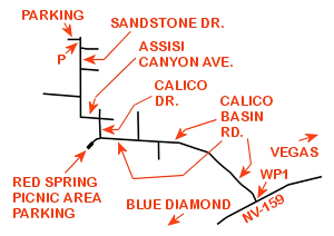
From the I-15 (Las Vegas Fwy.) interchange with W. Flamingo Rd. proceed South on I-15 (in the right 2 lanes) for 1.3 miles+- and take the off-ramp for County Rd. 215 West (Exit #36).
Continue South on Exit #36 (parallels I-15) following the signs for County Rd. 215 for 1.7 miles+- and take the off-ramp towards County Rd. 215 West.
Continue along the off-ramp for 0.20 miles+- and "bear" Right towards County Rd. 215 West eventually merging onto County Rd. 215 West in approx. 0.50 miles.
Continue on County Rd. 215 West, which transitions into County Rd. 215 North, for a total distance of 12.9 miles+- and take the off-ramp for NV-159 (Exit #26).
Continue along the off-ramp for 0.30 miles+- and turn Left onto NV-159 towards Red Rock Canyon.
Travel 3.80 miles+- on NV-159 to the signed turnoff for Calico Basin Rd. and WP1.
Turn Right onto Calico Basin Rd. traveling Northwesterly then Westerly for a total distance of 1.20 miles+- to the intersection of Calico Dr.
Turn Right (North) onto Calico Dr. traveling 0.10 miles+- to the intersection of Assisi Canyon Ave.
Turn Left (West) onto Assisi Canyon Ave. traveling 0.10 miles+- to the intersection of Sandstone Dr.
Turn Right (North) onto Sandstone Dr. traveling 0.50 miles+- to roads end and the gravel Kraft Mountain Parking Area entrance (waypoint "P") on your left.
Return by reversing route.
Approximately 23 miles from central Vegas Strip to the Kraft Mountain Parking Area and Ash Spring Trailhead.
