Rubber Ducky Tree
Red Rock Canyon N.C.A. - Nv.
Overview:
The "Rubber Ducky Tree" is located in Cottonwood Valley just north of Nevada State Highway 160 (NV-160).
At approximately 10 miles long (N-S) and 1 mile wide (E-W), the majority of the valley (divided by NV-160) is located within the Red Rock Canyon National Conservation Area (south of the fee area).
The area encompasses a great number of trails (hiking / biking) which provide a variety of "diverse" recreational opportunities.
Note: portions of this trail system are thought to have been (historically) created by wild burros (non-native) which can be seen in the area.
Today hikers, cyclists, rock climbers and 4WD adventurers coexist in this scenic area that "showcases" large colorful and very steep (east facing) peaks known geologically as the "Keystone Thrust" (a prominent fault).
The Keystone Thrust (called The Wilson Cliff's) include more than twenty mountain peaks and associated canyons that define the western edge of Cottonwood Valley.
The cliffs are made up of red, pink, yellow and tan sandstone that rise abruptly from the valley floor, offering extraordinary views from below.
Near the southern end Red Rock Canyon’s Late Night Trailhead (just north of NV-160) offers miles of hiking / biking trails and is the main trailhead for many hikes along these cliffs and canyons.
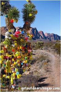
Although somewhat of a novelty, the "Rubber Ducky Tree" is one of many Joshua Trees that can be seen in the area.
The story: years ago a branch of the tree hung over the trail and someone tied a rubber ducky to warn cyclists to "DUCK" as they neared the tree.
Since then, visitors from far and wide have brought rubber duckies to hang on the tree.
Apparently, the tree is "monitored" and if too many ducks are present they are removed, although people keep hanging them.
Duckies or not, the hike to the "Rubber Ducky Tree" passes thru a beautiful area of Red Rock Canyon N.C.A. with a variety of desert plant species, wide open spaces and wonderful views.
Kids of all ages will appreciate this adventure.
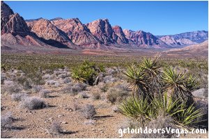
...trailside scenery
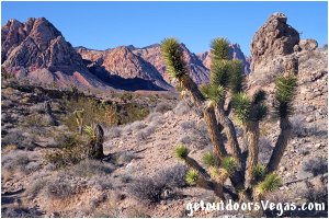
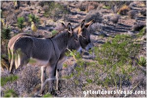
Information / Tips:
Bring plenty of water / snacks, hat, sunscreen, sunglasses and hiking boots (advised).
Make sure you have a full tank of gas and a fully pressurized spare tire.
Dogs are allowed on leash.
DON'T forget your camera.
..........
• Late Night Trailhead Parking amenities:
restroom, kiosk, oversized & ADA parking
• Fees for parking / trails: none
• Rubber Ducky Trail(s): not ADA accessible
• Best time: mid-week (Tue-Thur)
can be crowded (cyclists) on weekends
• No Water Available
..........
nearby: Ash Spring Trail
nearby: Calico Basin - South Trail
nearby: First Creek Canyon Trail
nearby: Red Spring Boardwalk
nearby: Scenic Loop Drive
nearby: Wilson Pimple
Warning:
This adventure involves travel to a relatively remote area, please refer to the section on desert travel for safety information.
• Bicycles are allowed on these trails
• Motor Vehicles: allowed on Black Velvet Rd.
• Watch for snakes
• Be mindful of lightning / flash floods
• No shade on any portion of trail
• AVOID THE AREA DURING EXTREME HEAT
• You are responsible for your own safety
Trail Directions:
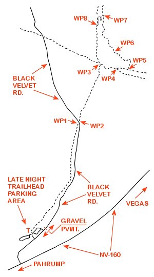
From the Late Night Trailhead Parking Area the trail to the "Rubber Ducky Tree" starts (waypoint T) on the East side of the main information kiosk (located just East of the restroom facility).
Head Northeasterly along the trail (runs parallel to the parking area and Black Velvet Rd.) for 0.5 miles+- to a point where the trail intersects Black Velvet Rd. and WP1.
From WP1 bear Left following Black Velvet Rd. in a Northerly direction for 150 feet+- to a trail intersection which bears Northeasterly and WP2.
From WP2 bear Right (Northeasterly) traveling along the trail for 0.26 miles+- to a "large" trail intersection area and WP3.
From WP3 "switchback" Right heading Southeasterly along the trail for 380 feet+- to a "Y" intersection and WP4.
From the "Y" intersection (WP4) bear left (Easterly) following the trail for 275 feet+- to another trail intersection and WP5.
From WP5 turn Left (Northeasterly) onto a trail which in short order turns Northerly (descending into a small wash) for a total distance of 0.13 miles+- to WP6 and the "Rubber Ducky Tree".
Return by reversing route.
Approx. hiking distance (out and back): 2.1 miles.
..........
Route Alternative:
From the "Rubber Ducky Tree" (WP6) hikers can continue Northerly for 0.19 miles+- to a trail intersection (WP7).
Note: the trail intersection (WP7) can be easy to miss as it "switchbacks" abruptly upslope towards the South-Southwest.
From WP7 "switchback hard" to the Left and follow the trail (upslope and out of the wash) for 0.12 miles+- (thru two tight switchbacks) to a "Y" intersection and WP8.
From WP8 continue straight ahead (Southerly) for 0.15 miles+- to the previously visited WP3.
From WP3 return to the trailhead by retracing your steps (WP3-WP2-WP1-trailhead).
Approx. hiking distance (utilizing this alternative): 2.29 miles.
..........
T: N36.01137 W115.43133
trailhead
WP1: N36.01764 W115.42779
trail @ Black Velvet Rd.
WP2: N36.01803 W115.42775
Black Velvet Rd. @ trail
WP3: N36.02146 W115.42614
trail junction
WP4: N36.02118 W115.42505
trail junction
WP5: N36.02112 W115.42414
trail junction
WP6: N36.02225 W115.42516
Rubber Ducky Tree
WP7: N36.02449 W115.42600
trail junction
WP8: N36.02362 W115.42647
trail junction
Note:
See desert travel for GPS Waypoint info
All distances and waypoints are approximate
Driving Directions:
From the I-15 (Las Vegas Fwy) interchange with W. Flamingo Rd. proceed South on I-15 for 4.5 miles+- to Exit #33.
Exit onto the Exit #33 offramp, traveling 0.4 miles+- (utilizing the right lane) and merge onto westbound Blue Diamond Rd. (NV-160).
Travel Westerly on Blue Diamond Rd. (NV-160) for 10.3 miles+- to the intersection of NV-160 and NV-159.
Continue West on NV-160 for 4.7 miles+- to the paved access road (sign marks the turnoff) for the Late Night Trailhead Parking Area.
Turn Right onto the paved access road traveling 0.1 miles+- to the Late Night Trailhead Parking Area (on your left).
Return by reversing route.
Approximately 20 miles from central Vegas Strip to the Late Night Trailhead Parking Area.
