White Owl Canyon
Lk. Mead Natl. Rec. Area
Overview:
White Owl Canyon (Owl Canyon) is a short slot canyon along a minor drainage within the Lake Mead National Recreation Area (driving directions below).
The canyon is notable for a short section of narrows where water (over the eons) has eroded thru rock layers formed from consolidated ancient alluvial fan deposits.
The walls are sinuous (curved) and sculpted for approximately 1/2 mile, with the narrowest section being fairly short and up to 100 feet deep.
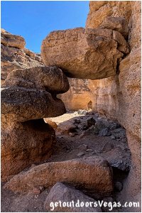
The canyon and specifically the narrows are quite colorful (grays / browns) and in places display interesting patterns of light and shadows.
While hiking through the narrows, watch for big "splashes" of "white wash" (Barn Owl poop) high on the rock walls (hence the canyons name).
Barn Owls are light colored with a distinctive heart-shaped face.
The undersides of these large owls are mostly white with the wings, back and top of head colored tan with gray highlights.
Beneath this "white wash" look for owl pellets along lower ledges or the canyon floor.
The pellets, usually 2 - 3 inches long and about 1 inch in diameter are oblong clumps of bone and fur that were regurgitated by the owls.
Barn Owls swallow their prey entirely: consuming everything (without ripping it apart), including the indigestible parts.
Unable to pass these indigestible parts, owls cough them up and spit them out.
Typically, large leg and arm bones along with skulls and jaws of prey are evident in the pellets and easy to see.
As the pellets are coughed up (not pooped out), they are relatively clean and safe to examine.
The owls here eat mostly rodents (desert woodrats and kangaroo rats) and are known to take birds, lizards, insects, mice, young rabbits and other small mammals if the opportunity arises.
Note: Unfortunately, hikers flush the Barn Owls off their roost, so its best to stay out of this canyon during early spring when the owls are nesting.
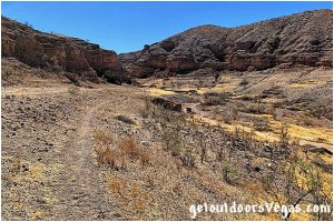
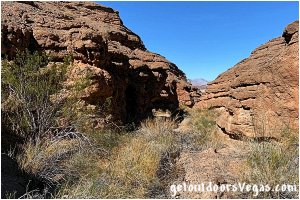
...trailside scenery
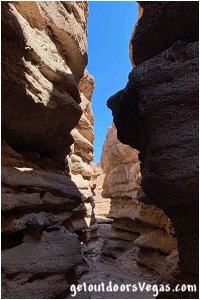
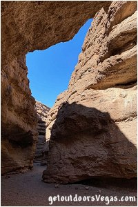
...trailside scenery
Information / Tips:
This adventure would make a great stopover while enjoying the Lake Mead National Recreation Area.
Bring plenty of water / snacks, hat, sunscreen, sunglasses and hiking boots (advised).
Make sure you have a full tank of gas and a fully pressurized spare tire, DON'T forget your camera.
..........
Rec. Area Hours 24hrs/day, 365days/year
2021 Entry Fee (valid 7 days): $25 vehicle & occ.
Free Entry Days (dates vary by year):
* M. L. King Jr. Day - mid January
* 1st day of Natl. Park Week - mid April
* Great Amer. Outdoors Act - EARLY AUGUST
* Natl. Park Service Birthday - LATE AUGUST
* Natl. Public Lands Day - LATE SEPTEMBER
* Veterans Day - mid November
..........
• Trailhead amenities include:
shaded picnic tables
barbeque pits
trash receptacles
restroom facility
ADA parking
• White Owl Canyon Hike: not ADA accessible
• No Water Available
..........
nearby: Bluff Trail
nearby: Shoreline Trail
nearby: Upper Gypsum Wash
nearby: Wetlands Trail
Warning:
This adventure involves travel to a relatively remote area, please refer to the section on desert travel for safety information.
• Be mindful of lightning / flash floods
• Watch for snakes
• AVOID THE AREA DURING EXTREME HEAT
• You are responsible for your own safety
Trail Directions:
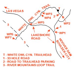
From the Trailhead (waypoint "T") at the northwest corner of the trailhead parking area, abruptly descend down an eroded and very steep loose rock pathway onto the flats below.
Note: this initial 300 foot+- section of the trail can be a challenging descent / ascent (90 feet+-) for certain individuals (use your own judgment).
On the flats the route travels 0.29 miles+- Northwesterly undulating across the dry lakebed (following use-trails) then turns Southwesterly (contouring the upslope terrain) eventually descending into the dry wash of White Owl Canyon and onto WP3.
From WP3 continue up the wash for just over 200 feet to a fork in the canyon and WP4.
From WP4 the trail veers Left at the canyon's fork and progresses further "upstream".
Shortly thereafter the walls steepen and narrow, eventually "towering" over the wash / trail as one travels thru the meandering first slot canyon area.
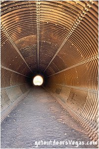
In due course, the slot canyon opens abruptly just before a culvert (WP5) which runs under Lakeshore Road, being approx. 0.27 miles "upstream" of WP4.
From WP5 the trail travels thru the culvert and the canyon narrows again just beyond the culvert's "upstream" end.
This second "upstream" slot canyon is deep and narrow, but less so compared to the previous slot "downstream" of Lakeshore Road.
At a distance of approx. 0.28 miles from WP5 one reaches a second "double" culvert (WP6) which runs under the old Lakeshore Road (now utilized as the River Mountains Loop Trail).
From WP6 the trail passes thru either of the "double" culverts exiting on the "upstream" end into a widening canyon, traveling 0.15 miles+- to WP7 and the end of this trail description.
Return by reversing route.
Approx. distance: 2.2 miles out and back.
..........
WP1: N36.10615 W114.84570
Lakeshore Rd. @ 33 Hole Rd.
WP2: N36.11026 W114.84295
33 Hole Rd. @ trailhead access road
T: N36.11152 W114.84425
trailhead
WP3: N36.11122 W114.84920
canyon narrows
WP4: N36.11078 W114.84942
fork in canyon
WP5: N36.10862 W114.85296
first culvert under Lakeshore Rd.
WP6: N36.10569 W114.85595
dual culverts under River Mtn. Loop Trail
WP7: N36.10434 W114.85780
turnaround point
Note:
See desert travel for GPS Waypoint info
All distances and waypoints are approximate
Driving Directions:
From the I-15 (Las Vegas Fwy) interchange with W. Flamingo Rd. proceed South on I-15 for just over 3 miles to Exit #34.
Exit onto the Exit #34 offramp, continue Southerly then Easterly (utilizing the left 2 lanes) eventually merging onto Eastbound I-215.
Travel Eastbound on I-215 for 10.5 miles+- to freeways end and continue straight onto W. Lake Mead Parkway (NV-564).
Continue Eastbound on W. Lake Mead Parkway (NV-564) which transitions (at intersection of Water St.) into E. Lake Mead Parkway (NV-564) for a total distance of 9 miles+- to the Lake Mead National Recreation Area Entry Station.
Continue Eastbound on E. Lake Mead Parkway for 0.3 miles+- to the intersection of E. Lake Mead Parkway, Northshore Rd and Lakeshore Road.
Continue straight onto Lakeshore Road traveling 3.5 miles+- to the intersection (WP1) with 33 Hole Road (signs mark the turnoff).
Turn Left (Northerly) onto 33 Hole Road traveling 0.3 miles+- to the first Left turn (WP2).
Turn Left (Westerly) traveling 400 feet+- along the asphalt road to a large parking area (trailhead in in the Northwest corner of parking area).
Return by reversing route.
Approximately 28 miles from central Vegas Strip to Trailhead Parking.
