Wetlands Trail
Lk. Mead Natl. Rec. Area
Overview:
Within Lk. Mead National Recreation Area (just East of the City of Henderson) the Wetlands Trail runs Easterly along the North side of the Las Vegas Wash.
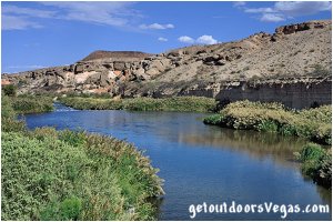
Here there is a deep, narrow, steep walled canyon full of vegetation.
Thru a sparsely vegetated desert along the top of bluffs (which overlook the wash) the trail descends along a series of narrow ridges into the canyon below, giving visitors a closeup look of this riparian corridor.
Birds and other wildlife can be seen in this "unique" desert habitat, attracted by water and "lush" vegetation (honey mesquite, saltbush, saltcedar, cattail etc.) which provides food sources and shelter.
For individuals interested in a "unique" desert stream and grand views of the desert and surrounding mountains, the Wetlands Trail is a short local hike for consideration.
Las Vegas Wash:
The Las Vegas Wash (12 miles+- long channel) feeds most of the Las Vegas Valley's excess water into Lake Mead.
The wash (often referred to as an urban river) exists in its present capacity because of the Las Vegas Valley's urban population.
Las Vegas Wash is fed by urban runoff, ground water, reclaimed water and stormwater.
Wetlands along the Las Vegas Wash filter / clean the water that passes thru them, purging residues from fertilizers, oils and other contaminants.
The wash passes thru the Clark County Wetlands Park, providing critical habitat for the areas many birds, mammals, reptiles and fish.
The Las Vegas Wash eventually passes under the man-made Lake Las Vegas (thru two 7 foot diameter pipes) terminating (downstream of the Wetlands Trail) at Lake Mead's Las Vegas Bay.
Providing water / habitat for many plants and animals, the Las Vegas Wash drainage is a true oasis in the desert.
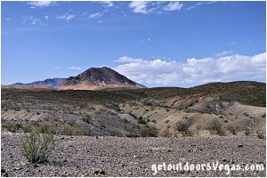
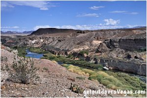
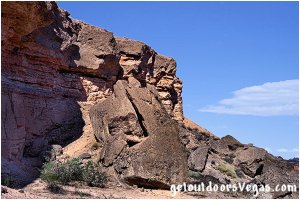
...trailside scenery
Information / Tips:
This adventure would make a great stopover while enjoying the Lake Mead National Recreation Area.
Bring plenty of water / snacks, hat, sunscreen, sunglasses and hiking boots (advised).
Make sure you have a full tank of gas and a fully pressurized spare tire.
Dogs are allowed on leash.
DON'T forget your camera / binoculars.
..........
Rec. Area Hours 24hrs/day, 365days/year
2021 Entry Fee (valid 7 days): $25 vehicle & occ.
Free Entry Days (dates vary by year):
* M. L. King Jr. Day - mid January
* 1st day of Natl. Park Week - mid April
* Great Amer. Outdoors Act - EARLY AUGUST
* Natl. Park Service Birthday - LATE AUGUST
* Natl. Public Lands Day - LATE SEPTEMBER
* Veterans Day - mid November
..........
• Trailhead amenities include:
trash receptacles
restroom facility
• Wetlands Trail: not ADA accessible
• No Water Available
..........
nearby: Bluff Trail
nearby: Shoreline Trail
nearby: Upper Gypsum Wash
nearby: White Owl Canyon
Warning:
This adventure involves travel to a relatively remote area, please refer to the section on desert travel for safety information.
• AVOID CONTACT WITH WATER
- urban runoff / treated sewage
- swift water hazard
- no swimming or wading
• Be mindful of lightning / flash floods
• Watch for snakes
• AVOID THE AREA DURING EXTREME HEAT
• You are responsible for your own safety
Trail Directions (see notes below):
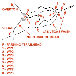
This description traverses a "loop" running counter-clockwise from the "official" trailhead (WP1) which ultimately descends into the Las Vegas Wash and eventually returns via a nearby canyon to a second "alternate" trailhead (WP8).
Starting at the aforementioned trailhead (WP1) walk Easterly along the well defined level trail for 565 feet+- to a trail intersection and WP2.
Turn Right (Southerly) following a use-trail 340 feet+- to trails end and WP3 (Las Vegas Wash Overlook).
Note: there is no guard fencing - stay away from the edge, watch yourself and your kids.
Continuing the hike, backtrack (Northerly) along the use-trail 340 feet+- to the intersection with the "main" trail (WP2).
From WP2 continue Easterly along the well defined "main" trail 550 feet+- to a narrowing ridgeline trail (minimal exposure) which descends abruptly via loose gravel and rocks (over uneven and rotting wooden stairs) to a trail intersection and WP4 being a total distance of 1070 feet+- East of WP2.
From WP4 take the Right (Southerly most) sharply descending and narrow use-trail (loose gravel and rock) for 180 feet+- to WP5.
From WP5 a "bulldozer bladed" trail runs upstream and "parallel" to the Las Vegas Wash for 1100 feet+- affording views of the water and vegetation from just above the canyon floor.
Within the wash a high concrete weir (waterfall) marks the "end" of the trail.
Return by backtracking downstream along the "bulldozed trail" 1100 feet+- to WP5.
Continuing from WP5 the "bulldozed trail" runs downstream 225 feet+- to WP6.
An 80 foot+- segment of this 225 foot+- trail section is highly eroded (abrupt, undercut remnants: Oct. 2021) and choked by encroaching vegetation (take care in this area).
Note: erosion may affect the viability of this section of trail in the future resulting in the need for an alternate approach to WP6 (see below).
From WP6 continue along the "bulldozed trail" (downstream, parallel to the Las Vegas Wash) for a short 525 feet+- to trails end (overgrown).
Retrace your route by backtracking 525 feet+- to WP6.
Once again at WP6 head Northwesterly (towards the parking area) up a canyon (graded roadway) traveling 460 feet+- to WP7.
From WP7 continue up canyon along the winding "graded roadway" for 1575 feet+- to the "alternate" trailhead (WP8) and parking area.
..........
Trail Summary:
• distance (as described above): 1.5 miles+-
• elevation gain / loss: 150 feet+-
..........
Alternate route(s):
If the trail section between WP5 and WP6 is not viable due to erosion, vegetation encroachment or personal preference then the alternative at WP5 would be to backtrack to WP4 and proceed to WP7 and WP6.
Once back at WP4 proceed down the Northerly most trail towards the "graded roadway" visible in the wash below thru a "series" of eroded and loose rock switchbacks (a few uneven rotten stairs) for 300 feet+- to WP7.
From WP7 proceed to WP6.
Note: trails described on this webpage can be
hiked in any combination or direction
..........
Trail Notes:
• not fully maintained
• areas of loose gravel
• steep eroded sections
• wooden steps (uneven / rotting)
• areas of narrow exposed trail
• areas of overgrown vegetation
..........
WP1: N36.12465 W114.90272
trailhead @ parking lot
WP2: N36.12495 W114.90087
trail junction
WP3: N36.12416 W114.90031
Las Vegas Wash Overlook
WP4: N36.12549 W114.89758
trail junction
WP5: N36.12525 W114.89727
trail junction
WP6: N36.12569 W114.89677
trail junction
WP7: N36.12597 W114.89816
trail junction
WP8: N36.12472 W114.90271
trailhead @ parking lot
Note:
See desert travel for GPS Waypoint info
All distances and waypoints are approximate
Driving Directions:
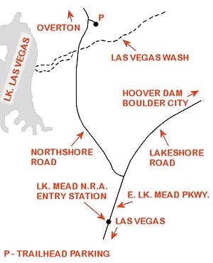
From the I-15 (Las Vegas Fwy) interchange with W. Flamingo Rd. proceed South on I-15 for just over 3 miles to Exit #34.
Exit onto the Exit #34 offramp, continue Southerly then Easterly (utilizing the left 2 lanes) eventually merging onto Eastbound I-215.
Travel Eastbound on I-215 for 10.5 miles+- to freeways end and continue straight onto W. Lake Mead Parkway (NV-564).
Continue Eastbound on W. Lake Mead Parkway (NV-564) which transitions (at intersection of Water St.) into E. Lake Mead Parkway (NV-564) for a total distance of 9 miles+- to the Lake Mead National Recreation Area Entry Station.
Continue Eastbound on E. Lake Mead Parkway for 0.3 miles+- to the intersection of E. Lake Mead Parkway, Northshore Road and Lakeshore Road.
Turn left (Northbound) on the Northshore Road traveling 1.2 miles+- to the turnoff for the Wetlands Trail access parking lot (signs mark the turnoff).
Turn right into the large gravel parking area (trailhead is in the Southeast corner).
Return by reversing route.
Approximately 25 miles from central Vegas Strip to Trailhead Parking.
