Shoreline Trail
Lk. Mead Natl. Rec. Area
Overview:
The Shoreline Trail, located in Lk. Mead National Recreation Area, is somewhat of an unusual hike.
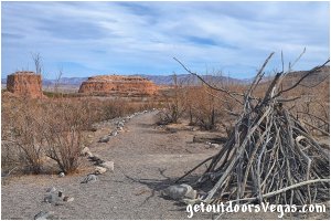
Due to Lk. Mead's historic low water levels, this trail actually runs along the former lakebed as evidenced by step-like formations (terraces) along the trail and slopes above you.
The now-dry lakebed "supports" saltcedar (an invasive species) and other opportunistic vegetation.
Also evident, are thousands of clam shells (also invasive) left high and dry by the lakes receding waters.
As "depressing" as this seems there is still a lot to see, with cool views and a few surprises.
The Las Vegas Wash, once underwater has been "reborn" in the area of the Shoreline Trail.
The Wash (12 miles+- long channel) feeds most of the Las Vegas Valley's excess water into Lake Mead.
Often referred to as an urban river the Wash exists in its present capacity because of the Las Vegas Valley's urban population and is fed by urban runoff, ground water, reclaimed water and stormwater.
The wetlands along the Las Vegas Wash filter / clean the water that passes thru them by purging residues from fertilizers, oils and other contaminants.
Due to the constant water source the Wash supports plant and animal communities while adding a welcome "swath of green" to the scenery.
A very short section of the Shoreline Trail runs next to the Wash (typically off in the distance) at the Las Vegas Wash narrows.
Here the Wash has cut thru the surrounding rock forming a short slot canyon with running water.
A very picturesque area.
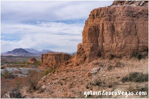
The "Pillars" are three very interesting, colorful and isolated buttes.
Once under water but now exposed due to Lk. Mead's low water level, these buttes "shoot out" of the landscape and "dominate" the views along the Shoreline Trail.
The trail passes next to two of the buttes for an up close look and all three provide interesting foreground elements for photography.
Essentially, when hiking the Shoreline Trail, its hard to take your eyes off of them as you progress along the trail.
Today, due to Lk. Mead's low water level, the area around the Shoreline Trail trailhead has been "somewhat" forgotten.
Here are "remnants" of a once vibrant and bustling area with a major boat ramp / support facilities, campground, large picnic area and ranger station.
The campground and picnic area are open, the ranger station is closed and the boat ramp now serves as the trailhead parking area.
One benefit however, the area sees very little use and chances are you will see very few (if any) other hikers along the trail making this adventure an enjoyable and different type of experience.
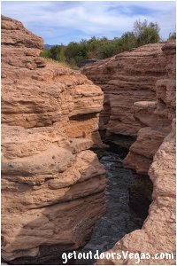
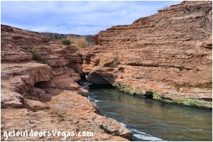
...trailside scenery
Information / Tips:
This adventure would make a great stopover while enjoying the Lake Mead National Recreation Area.
Bring plenty of water / snacks, hat, sunscreen, sunglasses and hiking boots (advised).
Make sure you have a full tank of gas and a fully pressurized spare tire, DON'T forget your camera.
..........
Rec. Area Hours 24hrs/day, 365days/year
2022 Entry Fee (valid 7 days): $25 vehicle & occ.
Free Entry Days (dates vary by year):
* M. L. King Jr. Day - mid January
* 1st day of Natl. Park Week - mid April
* Great Amer. Outdoors Act - EARLY AUGUST
* Natl. Park Service Birthday - LATE AUGUST
* Natl. Public Lands Day - LATE SEPTEMBER
* Veterans Day - mid November
..........
• Parking amenities: none
• Trailhead amenities: none
• Picnic Area amenities:
restroom facility
shaded picnic tables
barbecue pits
shade trees
trash receptacles
• Shoreline Trail: not ADA accessible
• Dogs: Allowed On Leash
• No Shade Along Trail
• No Water Available
..........
nearby: Bluff Trail
nearby: Upper Gypsum Wash
nearby: Wetlands Trail
nearby: White Owl Canyon
Warning:
This adventure involves travel to a relatively remote area, please refer to the section on desert travel for safety information.
• Be mindful of lightning / flash floods
• Watch for snakes
• AVOID THE AREA DURING EXTREME HEAT
• AVOID CONTACT WITH WATER
urban runoff / treated sewage
• You are responsible for your own safety
Trail Directions:
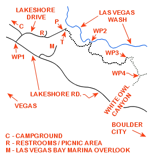
From the Shoreline Trail Parking Area (waypoint P) walk (downslope and Northeasterly) along the adjacent sidewalk (on your Right) for 125 feet+- to the Shoreline Trail trailhead (waypoint T), located 30 feet+- Right (Southeasterly) of the sidewalk.
From the trailhead travel Southeasterly along the well defined Shoreline Trail, eventually heading Easterly for a total distance of 0.42 miles+- to the area of the Las Vegas Wash narrows and WP2.
Note 1: the last 150 feet+- of trail prior to reaching WP2 "climbs" and is somewhat "exposed" as it skirts around a point.
For hikers uncomfortable with heights "parallel" the Shoreline Trail utilizing a side Wash that runs along the "base" of the "exposed" area, then traverse upslope (Southeasterly) to reach WP2.
Note 2: the Las Vegas Wash narrows can be see from WP2, being 75 feet+- downslope and Northerly of WP2.
Be careful (watch your kids) when "overlooking the narrows" as this small slot canyon (rushing water) is steep sided with hidden underwater hazards and "might" be impossible to get out of.
From WP2 continue along the Shoreline Trail in a Southerly, Southeasterly and in due course a Northeasterly direction for 0.63 miles+- to a "saddle" on the Southerly side of a large "isolated bluff" and WP3, being the end of this trail description.
Return by reversing route.
Approx. out and back distance (as described): 2.1 miles.
Note: see Trail Note #1 (below) for an additional hiking opportunity.
..........
Trail Notes:
(1) From WP3 the Shoreline Trail continues (not described on this web-page) in a South-Southeasterly direction for 0.30 miles+- to a "Y" intersection and WP4 located near the "mouth" of White Owl Canyon (see Trail Note #2 below).
From WP4 bear Right (South-Southwesterly) towards White Owl Canyon (see web-page link above) traveling 0.14 miles+- to White Owl Canyon's waypoint #3.
From White Owl Canyon's waypoint #3 proceed thru waypoint #s 4, 5 & 6 to White Owl Canyon's waypoint #7 (trails end).
Return by reversing route.
Approx. out and back distance from the Shoreline Trail trailhead (including the full White Owl Canyon alternative): 4.5 miles.
(2) This adventure utilizes "conventional" trails.
As opposed to the "conventional" trail, use-trails are sporadic in nature and often "venture out" in all directions.
In this area of Lake Mead N.R.A. many use-trails exist and can make things "somewhat" confusing.
Therefore it is recommended to utilize internet mapping resources such as aerial photography (not always current) and waypoint positions to visualize your route.
..........
WP1: N36.11788 W114.87167
Lakeshore Rd. @ Lakeshore Dr.
P: N36.11986 W114.86251
parking
T: N36.11977 W114.86186
trailhead
WP2: N36.11770 W114.85723
Las Vegas Wash narrows
WP3: N36.11555 W114.85034
bluff viewpoint - turnaround point
WP4: N36.11292 W114.84813
trail jct. White Owl Canyon alternative
Note:
See desert travel for GPS Waypoint info
All distances and waypoints are approximate
Driving Directions:
From the I-15 (Las Vegas Fwy) interchange with W. Flamingo Rd. proceed South on I-15 for just over 3 miles to Exit #34.
Exit onto the Exit #34 offramp, continue Southerly then Easterly (utilizing the left 2 lanes) eventually merging onto Eastbound I-215.
Travel Eastbound on I-215 for 10.5 miles+- to freeways end and continue straight onto W. Lake Mead Parkway (NV-564).
Continue Eastbound on W. Lake Mead Parkway (NV-564) which transitions (at intersection of Water St.) into E. Lake Mead Parkway (NV-564) for a total distance of 9 miles+- to the Lake Mead National Recreation Area Entry Station.
Continue Eastbound on E. Lake Mead Parkway for 0.3 miles+- to the intersection of E. Lake Mead Parkway, Northshore Rd. and Lakeshore Road.
Continue straight onto Lakeshore Road traveling 1.8 miles+- to the intersection (WP1) with Lakeshore Dr. (signs mark the turnoff).
Turn Left (Northeasterly) onto Lakeshore Dr. traveling 0.10 miles+- to the turnoff for the Las Vegas Bay Campground.
Continue (Straight) along Lakeshore Dr. eventually passing the Picnic Area (on your left) for a total distance of 0.24 miles+- to a point where a long ago "high and dry" boat ramp is seen running downslope and to the Right.
Bear Right (Northeasterly) "down" the large boat ramp traveling 0.24 miles+- to a series of barricades which prevent further travel and the Shoreline Trail Parking Area (waypoint P).
Return by reversing route.
Approximately 26 miles from central Vegas Strip to Shoreline Trail Parking Area.
