Bluff Trail
Lk. Mead Natl. Rec. Area
Overview:
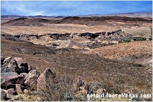
The Bluff Trail is a well-defined trail with grand views that runs along the bluffs overlooking the Las Vegas Wash.
The areas vegetation is sparse (no shade), allowing hikers to appreciate the geology of the area.
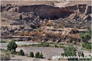
Along the wash erosion has undermined the surface layer of rock, resulting in large blocks collapsing into the wash under their own weight.
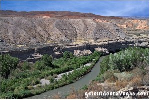
Within the Las Vegas Wash (near water) "dense" vegetation provides a stark contrast to the dry and arid slopes along the "canyon" rim.
Eventually turning away from the wash the trail climbs (gradually) and "terminates" on a low summit that overlooks the surrounding terrain.
With the Las Vegas Wash, geology, desert habitat and surrounding mountains as a backdrop, photographic possibilities are everywhere (make sure to look for wildlife).
Las Vegas Wash:
The Las Vegas Wash (12 miles+- long channel) feeds most of the Las Vegas Valley's excess water into Lake Mead.
The wash (often referred to as an urban river) exists in its present capacity because of the Las Vegas Valley's urban population.
Las Vegas Wash is fed by urban runoff, ground water, reclaimed water and stormwater.
Wetlands along the Las Vegas Wash filter / clean the water that passes thru them, purging residues from fertilizers, oils and other contaminants.
The wash passes thru the Clark County Wetlands Park, providing critical habitat for the areas many birds, mammals, reptiles and fish.
The Las Vegas Wash eventually passes under the man-made Lake Las Vegas (thru two 7 foot diameter pipes) terminating (just downstream of the Bluff Trail) at Lake Mead's Las Vegas Bay.
Providing water / habitat for many plants and animals, the Las Vegas Wash drainage is a true oasis in the desert.
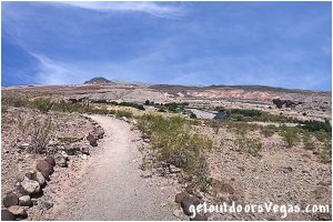
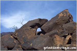
...trailside scenery
Information / Tips:
This adventure would make a great stopover while enjoying the Lake Mead National Recreation Area.
Bring plenty of water / snacks, hat, sunscreen, sunglasses and hiking boots (advised).
Make sure you have a full tank of gas and a fully pressurized spare tire, DON'T forget your camera and binoculars if you have them.
..........
Rec. Area Hours 24hrs/day, 365days/year
2021 Entry Fee (valid 7 days): $25 vehicle & occ.
Free Entry Days (dates vary by year):
* M. L. King Jr. Day - mid January
* 1st day of Natl. Park Week - mid April
* Great Amer. Outdoors Act - EARLY AUGUST
* Natl. Park Service Birthday - LATE AUGUST
* Natl. Public Lands Day - LATE SEPTEMBER
* Veterans Day - mid November
..........
• Trailhead Parking amenities:
restroom facility (nearby - campground use)
trash receptacles (campground use)
2 picnic tables (day use area)
information kiosk
campground pay station
• Trailhead amenities: none
amphitheater 150 feet+- North (views)
..........
• Bluff Trail Hike: not ADA accessible
• No Shade along Trail
• No Water Available (campground use)
..........
nearby: Shoreline Trail
nearby: Upper Gypsum Wash
nearby: Wetlands Trail
nearby: White Owl Canyon
Warning:
This adventure involves travel to a relatively remote area, please refer to the section on desert travel for safety information.
• Be careful around drop-offs / steep slopes
(watch your kids)
• Be mindful of lightning / flash floods
• Watch for snakes
• AVOID THE AREA DURING EXTREME HEAT
• You are responsible for your own safety
Trail Directions:
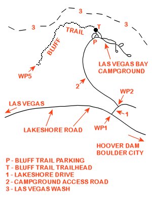
From the day-use parking area (driving directions below) walk Northerly thru the campground.
The trailhead (Waypoint "T") lies between campsites 72 and 74 and is marked by a sign (campsite numbers are attached to the fire grilling post).
The gravel trail runs Northerly 150 feet+- to the campsite amphitheater, which affords nice views of the area.
Note: this initial portion of the trail to the amphitheater "could" be considered ADA accessible (use your own discretion).
From the amphitheater area the Bluff Trail (becomes rocky - not ADA accessible) veers Left and continues Northerly then Westerly along the edge of the bluffs that overlook the Las Vegas Wash.
Hiking along the bluff edges, large blocks have broken off and fallen into the wash (also evident across the wash), a result of the waters of Las Vegas Wash eroding soil (over the eons) undermining these blocks which eventually collapse under their own weight.
Thru this section the trail is relatively flat (rolling), contouring the upslope terrain and crossing into and out of minor washes that drain northerly to the Las Vegas Wash.
About half way to trails end (summit), the trail bends Southwesterly, steepens slightly and progresses away from the Las Vegas Wash.
Continuing Southwesterly the trail runs along (sometimes closely) the edge of a bluff with a steep sideslope of loose soil to the West.
Once past this "exposed" Westerly bluff edge, the trail generally continues upslope (with flat sections) towards it's summit region.
Nearing the summit the trail climbs at it's steepest grade, rounds a dark granite rock outcrop then turns abruptly running up a short ridgeline to the summit area (WP5) and the end of this trail description.**
Return by reversing route.
** The summit area (WP5) is "marked" by two
large cairns (mounds of stone), please do
not add stones to these artificial mounds
** From WP5 a use-trail continues downslope
Westerly then turns North-Northwesterly
climbing to a high point that lies approx.
0.28 miles distant (straight line) of WP5
.....
Trail Summary
Distance: 1.8 miles+- (out & back)
Elevation Gain: 140 feet+-
..........
WP1: N36.11789 W114.87168
Lakeshore Rd. @ Lakeshore Dr.
WP2: N36.11898 W114.87056
Lakeshore Dr. @ campground access road
P: N36.12823 W114.87474
parking
T: N36.12931 W114.87443
trailhead
WP5: N36.12470 W114.88430
summit - turnaround point
Note:
See desert travel for GPS Waypoint info
All distances and waypoints are approximate
Driving Directions:
From the I-15 (Las Vegas Fwy) interchange with W. Flamingo Rd. proceed South on I-15 for just over 3 miles to Exit #34.
Exit onto the Exit #34 offramp, continue Southerly then Easterly (utilizing the left 2 lanes) eventually merging onto Eastbound I-215.
Travel Eastbound on I-215 for 10.5 miles+- to freeways end and continue straight onto W. Lake Mead Parkway (NV-564).
Continue Eastbound on W. Lake Mead Parkway (NV-564) which transitions (at intersection of Water St.) into E. Lake Mead Parkway (NV-564) for a total distance of 9 miles+- to the Lake Mead National Recreation Area Entry Station.
Continue Eastbound on E. Lake Mead Parkway for 0.3 miles+- to the intersection of E. Lake Mead Parkway, Northshore Road and Lakeshore Road.
Continue straight onto Lakeshore Road traveling 1.8 miles+- to the intersection (WP1) with Lakeshore Drive (sign for Las Vegas Bay marks the turnoff).
Turn Left (Northerly) onto Lakeshore Drive traveling 500 feet+- to the first Left turn and WP2 (campground access road).
Turn Left (Westerly) onto the campground access road traveling 0.8 miles+- (just entering the campground area) to a small gravel day-use parking area (on Right - this is the parking area for the Bluff Trail) and Waypoint "P".
Note: Do not park in any of the campsites.
Return by reversing route.
Approximately 27 miles from the central Vegas Strip to the Bluff Trail day-use parking area.
