Upper Gypsum Wash
Lk. Mead Natl. Rec. Area
Overview:
Upper Gypsum Wash (as defined for this web-page) is a 2.5 mile+- portion of Gypsum Wash, lying just "upstream" of Northshore Rd. within Lk. Mead Natl. Rec. Area.
This highly eroded "waterway" carries surface runoff from the desert highlands located East of the Las Vegas Valley to Lake Mead.
Gypsum Wash is an ephemeral stream, defined as a stream (or channel) that flows only briefly during and following periods of intense rainfall within the immediate location.
Desert environments are well known for having soils that are typically compacted or poorly draining (impermeable).
Since these soils are unable to absorb rainfall, the water quickly drains into washes (or channels) creating the possibility of flash flooding.
This swift flowing (although infrequent) water is responsible for most of the erosion that takes place within desert washes and their tributaries, Gypsum Wash being no exception.
A defining technical characteristic of ephemeral streams are those watercourses where the water running in the channel is at all times separated from, and unrelated to, the ground water table.
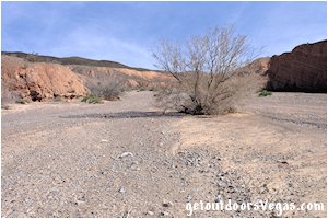
A hike up Upper Gypsum Wash "displays" the typical appearance of a seasonally active desert wash: sparse vegetation, a broad floodplain, steep often vertical walls, typical desert color and interesting geology.
Within the wash there is evidence of the "force and effect" of floodwaters over time, the braiding / meandering of "stream" channels and deposition of materials, undercutting and collapse of the washes walls and some very interesting erosional features (see images below).
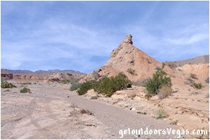
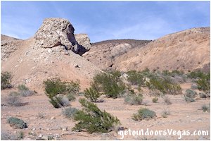
...Gypsum Wash scenery
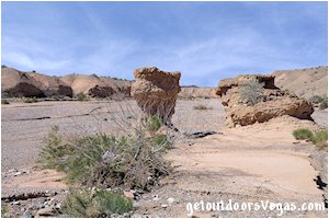
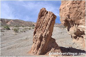
...Gypsum Wash scenery

Information / Tips:
This adventure would make a great stopover while enjoying the Lake Mead National Recreation Area.
Bring plenty of water / snacks, hat, sunscreen, sunglasses and hiking boots (advised).
Keep an eye out for wildlife (wild horse and burro, Bighorn Sheep, lizards, birds and of course snakes).
DON'T forget your camera.
• Trailhead Parking amenities: None
• Upper Gypsum Wash Hike: not ADA accessible
• Dogs are permitted (on leash)
• Gypsum Wash is a multi-use area: don't be
alarmed to see off-road vehicles within the
wash (infrequent)
• within Gypsum Wash are areas with gypsum
embedded in the soil, this mineral is "sparkly"
and can be seen on the sides of and along
the floodplain of Gypsum Wash: the visibility
of this mineral is "enhanced" on sunny days
• No Appreciable Shade
• No Water Available
..........
Rec. Area Hours 24hrs/day, 365days/year
2024 Entry Fee (valid 7 days): $25 vehicle & occ.
Free Entry Days (dates vary by year):
* M. L. King Jr. Day - mid January
* 1st day of Natl. Park Week - mid April
* Great Amer. Outdoors Act - EARLY AUGUST
* Natl. Park Service Birthday - LATE AUGUST
* Natl. Public Lands Day - LATE SEPTEMBER
* Veterans Day - mid November
..........
nearby: Bluff Trail
nearby: Shoreline Trail
nearby: Wetlands Trail
nearby: White Owl Canyon
Warning:
This adventure involves travel to a relatively remote area, please refer to the section on desert travel for safety information.
Make sure you have a full tank of gas and a fully pressurized spare tire.
• This route is within an isolated area, don't
expect to see any other hikers, especially
if hiking mid-week
• Be mindful of lightning / flash floods
• Watch for snakes
• NO CELL PHONE COVERAGE
• AVOID THE AREA DURING EXTREME HEAT
• You are responsible for your own safety
Hiking Route Directions:
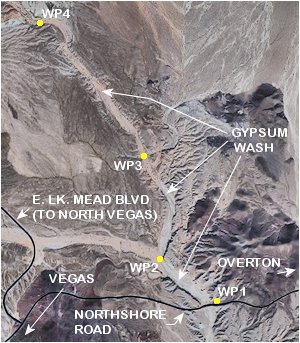
From the Gypsum Wash parking area (see driving directions below) proceed to the "trailhead" (WP1) located at the Westerly end of the parking area where the terrain drops off into Gypsum Wash.
Once at WP1, bear slightly Right and work your way downslope (utilizing use-trails) into Gypsum Wash.
Note: this initial area (approx. 100 ft+- in length) is impossible to describe, therefore choose your route carefully for there are large boulders, minimal exposure, steep slopes and loose gravel to navigate thru.
Once in Gypsum Wash bear Right (upstream - Northwesterly) "meandering thru" the wash to a point where a significant unnamed side wash is visible to the Left (Westerly) and WP2, being 0.53 miles+- distant of WP1.
From WP2 bear Right (Northerly) "meandering thru" Gypsum Wash as it turns Northwesterly to a second, less significant unnamed side wash to the Right (Easterly) and WP3, being 0.78 miles+- distant of WP2.
From WP3 continue straight (Northwesterly) "meandering thru" Gypsum Wash (eventually bears Westerly) to WP4, being 1.29 miles+- distant of WP3, and the end of this "route" description (see map below).
Return by reversing route.
..........
Note: it is recommended to utilize internet mapping resources such as aerial photography (not always current) and the provided waypoint positions to visualize your route prior to visiting this area.
Following the route as described above, hikers with a map (include aerial photography) can keep track of their position (more or less).
Keep an eye on your surroundings (look back often) when hiking in this area, utilizing landmarks will help on your return route.
This adventure requires minimal route finding and terrain awareness, inexperienced persons should consider traveling with an experienced person or group.
The use of a handheld GPS unit is recommended, know your GPS device's settings and use.
Remember: you are responsible for your own safety.
..........
Hiking Route Summary (as described):
Distance: 5.2 miles+- (out & back)
* within Gypsum Wash there are no formal hiking
trails: expect your actual hiking distance to vary
by utilizing a "meandering" route which will help
to bypass areas of soft sand, loose gravel and
other obstacles - not to mention exploring other
areas of interest
* quoted distance based on "centerline" of wash
..........
WP1: N36.14524 W114.86458
trailhead @ parking area
WP2: N36.14966 W114.87131
gypsum wash @ side wash
WP3: N36.15998 W114.87340
gypsum wash @ side wash
WP4: N36.17354 W114.88675
gypsum wash turnaround
Note:
See desert travel for GPS Waypoint info
All distances and waypoints are approximate
Driving Directions:
From the intersection of NV-564 (E. Lk. Mead Pkwy.) and NV-167 (Northshore Rd.) within Lk. Mead National Recreation Area head North on Northshore Rd. for 3.2 miles+- to the intersection of Northshore Rd. and E. Lk. Mead Blvd.
Continue Northbound on Northshore Rd. and turn Left into a wide gravel parking area (unmarked - WP1) immediately after crossing over Gypsum Wash: a total distance of 1.5 miles+- North of the previously mentioned E. Lk. Mead Blvd.
Of Note: this gravel parking area is very rocky with "noteworthy" differences in elevation between the edge of Northshore Rd. and the gravel parking area itself (use caution).
Be Aware Of oncoming (Southbound) traffic as vehicles tend to approach "very" quickly (speed limit: 50mph) and sight visibility in this area is "somewhat" limited.
Return by reversing route.
Approx. 29 miles from central Vegas Strip via I-15 South, I-215 East, NV-564 East (E. Lk. Mead Pkwy.) and NV-167 (Northshore Rd.) to the parking area / trailhead (WP1) for the Upper Gypsum Wash adventure (described above).
