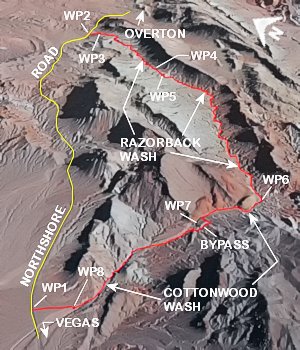
Razorback Wash (North)
Lk. Mead National Rec. Area
Overview:
Razorback Wash (North) is a very nice hike that runs about 5.49 miles through the Pinto Valley Wilderness Area.
Located within Lake Mead National Recreation Area, the route follows a wash (Razorback Wash) "which parallels" the "northwesterly face" of Razorback Ridge to Cottonwood Wash, then runs down Cottonwood Wash to complete the hike.
This route begins at Mile 21.8+- on Northshore Rd. (WP2) and ends at Milepost 18.2+- on Northshore Rd. (WP1), so a "car shuttle is required".
Along this route the walking is for the most part easy.
Razorback Wash itself is generally narrow and sinuous (curvy) while Cottonwood Wash is generally wider and less sinuous in nature.
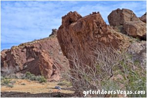
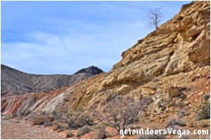
Both washes are colorful in their own way with surrounding scenery being quite spectacular and photogenic, making this hike one of the best hikes along Northshore Rd.
Being a cross-country adventure, a majority of the route follows two very nice "desert washes" and for the most part is "well defined" (see trail directions below).
In places the route is "not always" obvious, therefore "visualizing" this route online (along with the use of GPS) is recommended.
If you are "new to traveling" in the desert find an experienced person or group to hike with.
Although there is nothing "unusually" dangerous about this route, the region is very remote, therefore hiking here should be considered in a cautious manner.
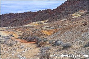
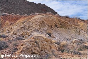
...trailside scenery
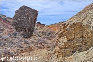
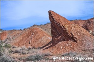
...trailside scenery
Information / Tips:
This adventure would make a great stopover while enjoying the Lake Mead National Recreation Area.
Bring plenty of water / snacks, hat, sunscreen, sunglasses and sturdy shoes (hiking boots advised).
Keep an eye out for wildlife (wild horse and burro, Bighorn Sheep, lizards, birds and of course snakes).
DON'T forget your camera.
• Parking area amenities (WP1 & WP2): None
(vault toilet location: Milepost 20.5+-
at the Northshore Summit Trailhead)
• Razorback Wash Hike: not ADA accessible
• Dogs are permitted (on leash)
• Limited Shade
• No Water Available
• Use Caution Around Northshore Road
(watch yourself and your kids)
..........
Rec. Area Hours 24hrs/day, 365days/year
2026 Entry Fee (valid 7 days): $25 vehicle & occ.
Free Entry Days (dates vary by year):
* M. L. King Jr. Day - mid January
* 1st day of Natl. Park Week - mid April
* Great Amer. Outdoors Act - EARLY AUGUST
* Natl. Park Service Birthday - LATE AUGUST
* Natl. Public Lands Day - LATE SEPTEMBER
* Veterans Day - mid November
..........
nearby: Bowl of Fire - Southwest
nearby: Cottonwood Wash
nearby: Lower Lovell Wash
nearby: Northshore Summit
nearby: Redstone
Warning:
This adventure involves travel to a relatively remote area, please refer to the section on desert travel for safety information.
Make sure you have a full tank of gas and a fully pressurized spare tire.
• This route is within an isolated area, don't
expect to see any other hikers, especially
if hiking mid-week
• Be Mindful of Lightning / Flash Floods
• Watch for Snakes
• NO CELL PHONE COVERAGE
• AVOID THE AREA DURING EXTREME HEAT
• You are responsible for your own safety
Trail Directions:
From the Trailhead (WP2) the route runs Southeasterly along open desert (no trail) for 300 feet+- to a small side wash which "drains" into Razorback Wash proper.
Once at the side wash descend (utilizing a safe spot) into Razorback Wash and WP3, being 500 feet+- distant of WP2.
From WP3 continue Southerly (upstream) in Razorback Wash.
Within this section of Razorback Wash the hiking is easy and the route is always obvious (stay in main wash), with great scenery and interesting geology on display.
At WP4, 1.42 miles+- upstream of WP3 Razorback Wash starts to "significantly" narrow, possibly a point of confusion for some hikers.
From (WP4) continue straight (do not bear Right) within the ever narrowing Razorback Wash eventually seeing an "old two track" road (heavily eroded) which continues from Razorback Wash's headwaters upslope to a low saddle and WP5, being 0.26 miles+- distant of WP4.
The low saddle (WP5) is a great spot to stop (no shade) and have a snack / hydrate while enjoying the views of Razorback Wash in its entirety.
Note: while enjoying the views atop the "low saddle" (WP5) visualize your route forward.
At WP5 there are two use trails, one that veers Westerly and one that "immediately loses elevation" in a Southwesterly direction (straight ahead), this is the correct route forward.
From WP5 continue straight ahead (quickly losing elevation) along said use trail to a small side wash, within this wash bear left (downstream) which enters into Razorback Wash proper (0.25 miles+- from WP5).
Once in Razorback Wash proper the route downstream is colorful, very interesting and obvious (just stay in the wash).
Eventually, Razorback Wash "intersects" with Cottonwood Wash at WP6, being 2.15 miles+- distant of WP5.
Within Cottonwood Wash the scenery / geology continues, with a pour-over (dry waterfall) and a small slot canyon along the way.
From WP6 bear right (Northwesterly) into Cottonwood Wash, winding downstream to the top of a 12 foot+- high pour-over (dry waterfall) and WP7, being 0.49 miles+- distant of WP6.
Note: for hikers uncomfortable descending the pour-over a "Bypass" is available (see Route Alternative below).
From the bottom of the pour-over continue downstream (in Cottonwood Wash) in a Northwesterly direction to WP8, being 0.91 miles+- distant of WP7.
From WP8 "turn right" Northerly ascending a use trail to the North-Northeasterly "edge" of Cottonwood Wash then bear Northwesterly across open desert (no trail) to WP1, being 0.17 miles+- distant of WP8, and the end of this trail description.
Approx. hiking distance as described (WP2 to WP1): 5.49 miles.
Trail Notes:
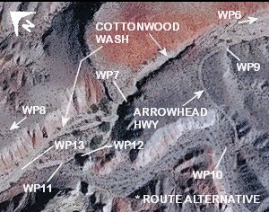
(1) A Historic Water Trough (WP12), utilized to fill automobile radiators along the old Arrowhead Hwy, lies 200 feet+- Westerly of a 12 foot+- high pour-over (dry waterfall - WP7) at Cottonwood Spring.
This "highway" was the first scenic highway running between Los Angeles and Salt Lake City via southern Nevada.
Remnants of the Arrowhead Highway as it "meandered" into and out of Cottonwood Wash are still visible and can be seen by utilizing internet mapping resources (aerial photography).
For directions to the Historic Water Trough (see Route Alternative below).
(2) Desert "washes" are dynamic ecosystems.
Although seemingly static in nature, meandering channels within desert canyons are subject to "realignment" due to heavy rainfall (flash floods).
Therefore, do not expect descriptions that "rely" on these meandering channels to provide a "concrete" point of reference.
Utilize internet mapping resources such as aerial photography (not always current) and waypoint positions to visualize "landmarks" which are more permanent in nature.
..........
Route Alternative (Bypass):
This route alternative (for individuals wanting to avoid the pour-over) utilizes a portion of the old Arrowhead Highway (see map below).
At a point 0.41 miles+- downstream of WP6 (430 feet+- upstream of WP7) look for a two track dirt road (is very evident) running somewhat parallel to and rising above the Left (Southwesterly) edge of Cottonwood Wash.
Exit the wash toward the two track dirt road (Arrowhead Highway) arriving at WP9, located in the "first well defined" section of the road.
From WP9 continue along the Arrowhead Hwy bearing Northwesterly then Southerly to a point where the road "hooks sharply" to the Right (Westerly) to WP10, being 40 feet+- Easterly of a side wash and 0.08 miles+- distant of WP9.
From WP10 enter the side wash then bear Right following the wash (downstream) in a Northwesterly direction to a "well defined" (braided) channel of Cottonwood Wash and WP11, being 0.12 miles+- distant of WP10.
Note: from WP11 bear Right (Easterly) traveling 80 feet+- (upstream) to the Historic Water Trough (WP12).
Upon reaching the water trough hikers can continue "upstream" along the channel to Cottonwood Spring and the pour-over (WP7) or "backtrack" towards WP11 to continue along the alternate route.
Back at WP11 bear Westerly (downstream) traveling 165 feet+- along said "braided channel" to WP13, then continue downstream within Cottonwood Wash to WP8.
..........
WP1: N36.21092 W114.65638
parking area1
WP2: N36.22856 W114.59951
parking area2
WP3: N36.22786 W114.59818
in Razorback Wash
WP4: N36.21558 W114.61124
Razorback Wash narrows
WP5: N36.21305 W114.61438
low saddle (Razorback Wash)
WP6: N36.19814 W114.63817
Razorback Wash @ Cottonwood Wash
WP7: N36.20268 W114.64332
Cottonwood Spring / pour over
WP8: N36.20822 W114.65545
leave Cottonwood Wash
WP9: N36.20216 W114.64207
bypass
WP10: N36.20157 W114.64289
bypass
WP11: N36.20282 W114.64417
bypass
WP12: N36.20273 W114.64398
Historic Water Trough
WP13: N36.20314 W114.64456
bypass
Note:
See desert travel for GPS Waypoint info
All distances and waypoints are approximate
Driving Directions:
From the intersection of NV-564 (E. Lk. Mead Pkwy.) and NV-167 (Northshore Rd.) within Lk. Mead National Recreation Area head North on Northshore Rd. for 18.2 miles+- to a paved pullout (waypoint WP1) on the Left (North) side of the road.
Note 1: be aware of oncoming traffic, as the view is somewhat compromised by a curve in the road.
Note 2: at this parking area (WP1) "drop off" a vehicle, this is where you will end the Razorback Wash (North) adventure.
Once your "dropped off" vehicle is secure, load up all passengers (and gear) into your second vehicle.
Continue North on Northshore Rd. for an additional 3.6 miles+- to a paved pullout (WP2 - Mile Marker 21.8+-) on the Right (Southerly) side of the road, being the parking / trailhead location for the Razorback Wash (North) adventure.
Note 3: the two parking areas described above (WP1 / WP2) have no signage, therefore keep an eye on the "Mile Markers" as you progress Northbound on Northshore Rd.
Return by reversing route.
Approx. 46 miles from central Vegas Strip via I-15 South, I-215 East, NV-564 East (E. Lk. Mead Pkwy.) and NV-167 (Northshore Rd.) to the Razorback Wash Trailhead (WP2).
