Northshore Summit
Lk. Mead Natl. Rec. Area
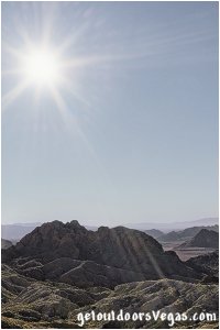
Located within the Lake Mead National Recreation Area the Northshore Road is a beautiful drive that provides great vistas and interesting geology.
Along the Northshore Road the Northshore Summit Trail is a perfect place for a short hike with amazing panoramic views of the surrounding desert landscape.
Views from the summit include the Muddy Mountains, Northshore Peak, the Bowl of Fire's vibrant red rocks, the Bitter Springs Valley, the Virgin Basin and a peekaboo view of Lake Mead in the distance.
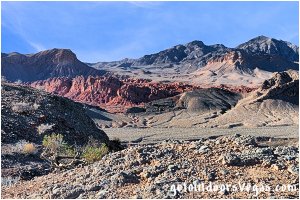
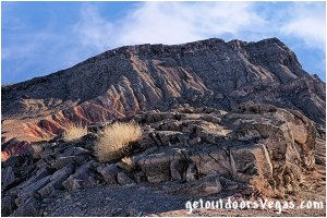
With sparse vegetation, open vistas and amazing geology the Northshore Summit Trail is a great place to experience and photograph the vastness and amazing colors of this portion of the Lake Mead National Recreation Area.

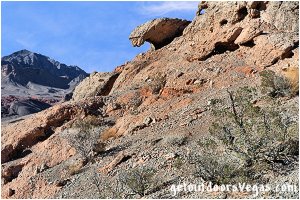
...trailside scenery
Information / Tips:
This adventure would make a great stopover while enjoying the Lake Mead National Recreation Area.
Bring plenty of water / snacks, hat, sunscreen, sunglasses and sturdy shoes (hiking boots advised).
Keep an eye out for wildlife (wild horse and burro, lizards, birds and of course snakes).
DON'T forget your camera.
• Trailhead amenities include:
vault toilet (ADA accessible)
trash receptacles
trailhead information sign
oversized parking
ADA parking
• Northshore Summit Hike: not ADA accessible
• Dogs are permitted (on leash)
• No Shade
• No Water Available
• Steep Slopes / Dropoffs in Summit Area
(watch yourself and your kids)
..........
Rec. Area Hours 24hrs/day, 365days/year
2021 Entry Fee (valid 7 days): $25 vehicle & occ.
Free Entry Days (dates vary by year):
* M. L. King Jr. Day - mid January
* 1st day of Natl. Park Week - mid April
* Great Amer. Outdoors Act - EARLY AUGUST
* Natl. Park Service Birthday - LATE AUGUST
* Natl. Public Lands Day - LATE SEPTEMBER
* Veterans Day - mid November
..........
nearby: Bowl of Fire - Southwest
nearby: Cottonwood Wash
nearby: Lower Lovell Wash
nearby: Redstone
Warning:
This adventure involves travel to a relatively remote area, please refer to the section on desert travel for safety information.
Avoid the area during extreme heat.
Make sure you have a full tank of gas and a fully pressurized spare tire.
Remember you are responsible for your own safety.
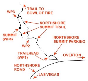
Trail Directions (see map below):
Starting at the Northshore Summit Trailhead (WP1) hike Northwesterly, along a well defined trail which gradually steepens, for 0.16 miles+- to a trail intersection and WP2.
Note: upon arriving at WP2 hikers have a choice: "ascend steeply" via a use-trail directly to the Northshore Summit (straight ahead - see alternative below) or "hike" the more gentle "constructed" trail which bears right.
From WP2 bear right on the "constructed" trail (ascends the Easterly slopes of Northshore Summit) traveling 0.15 miles+- to a trail intersection and WP3.
Note: upon arriving at WP3 hikers can choose to continue toward the Northshore Summit (bear left) or follow the Bowl of Fire trail (bear right - see alternative below).
From WP3 bear left, towards the Northshore Summit, traveling 0.7 miles+- to the summit area and WP4.
Return by reversing route.
..........
Route Alternatives (see map below):
(1) From WP2 (see trail directions above) a direct route (use-trail) heads directly to the Northshore Summit area (WP4).
This segment is 0.10 miles+- in length and entails a steep loose rock "scramble" which may not be suitable for certain individuals (use your own judgment).
(2) From WP2 (see trail directions above) hikers can "make" a loop hike.
This route travels thru WP's 1-2-3-4-2-1 running in a counter-clockwise direction; or could be hiked in a clockwise direction if so desired.
(3) From WP3 (see trail directions above) hikers can add distance to their adventure by following the Bowl of Fire trail in a Northwesterly direction for approx. 0.45 miles to a point where the trail descends "very steeply" to the valley below.
This alternative route "traverses" along a undulating ridgeline, affording great views of the Bowl of Fire and surrounding desert terrain.
Return to WP3 by reversing route.
Adds a total distance (out & back) of 0.90 miles+- to the Northshore Summit adventure.
..........
WP1: N36.22719 W114.62137
trailhead
WP2: N36.22852 W114.62308
trail junction
WP3: N36.23018 W114.62401
trail junction
WP4: N36.22929 W114.62387
Northshore Summit
..........
Trail Summary (Northshore Summit only):
0.76 miles+- (WP's 1-2-3-4 ...out & back)
0.52 miles+- (WP's 1-2-4 ...out & back)
0.64 miles+- (WP's 1-2-3-4-2-1 ...loop)
elev. difference: 190 feet+- (WP1-WP4)
..........
Note:
See desert travel for GPS Waypoint info
All distances and waypoints are approximate
Driving Directions:
From the intersection of NV-564 (E. Lk. Mead Pkwy.) and NV-167 (Northshore Rd.) within Lk. Mead National Recreation Area head North on Northshore Rd. for 20.5 miles+- to the paved parking area (left turn) for the Northshore Summit Parking Area and trailhead.
Note: trailhead parking is marked by a small hiking / viewpoint sign 300 feet+- shy of turnoff.
Approximately 44.5 miles from central Vegas Strip via I-15 South, I-215 East, NV-564 East (E. Lk. Mead Pkwy.) and NV-167 (Northshore Rd.) to the Northshore Summit Parking Area.
Return by reversing route.
