Lower Lovell Wash
Lk. Mead Natl. Rec. Area
Overview:
Lower Lovell Wash (as defined for this web-page) is a 1 mile+- portion of Lovell Wash, lying just "upstream" of Northshore Rd. within Lk. Mead Natl. Rec. Area.
For a majority of its course this section of Lower Lovell Wash is a wide and steep sided wash, characterized by typical desert color and interesting geology.
However, "hidden" within this desert wash and an adjoining side wash are some "secrets" most visitors are unaware of.
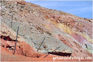
At a point approx. 1/3 of a mile "upstream" of the concrete box culvert where Lovell Wash crosses underneath Northshore Rd. hikers round a bend in the wash, abruptly coming face to face with a kaleidoscope of yellow and red formations (not visible from Northshore Rd.) which lie in stark contrast to the surrounding terrain: a real eye opener.
Within this area a "small side wash" intersects Lovell Wash.
Exploring this "unnamed" wash hikers experience more of the yellow and red formations which "quickly" fade to typical desert color with red formations seemingly around every short and tight bend.
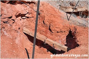
A bonus within the side wash is an "historic" Placer Mine with a open vertical shaft (be careful) which adds ambience to this colorful and very beautiful area.
Of Note: this relatively small portion of Lovell Wash is thought (by many) to contain some of the best colored rock formations in the state of Nevada.
Continuing up Lovell Wash thru the previously described colorful area (which quickly fades to typical desert color) and around a sweeping bend in Lovell Wash another completely different area dominated by white, sandy brown and occasional blue-green formations lies approx. 4/10 of a mile ahead.
Not to be outdone by is more colorful neighbor located just "downstream" this area stands out as very colorful in its own right, is more expansive and like its "downstream" neighbor is geologically very interesting.
Of all there is to see and do within Lk. Mead Natl. Rec. Area this adventure is unique, not well known and seldom visited by others.
It is a relative easy hike to a beautiful area with a couple of things to be aware of (see hiking route directions below) and some nice "surprises" along the way.
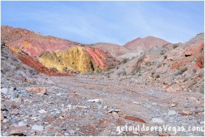
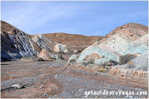
...trailside scenery
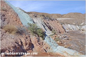
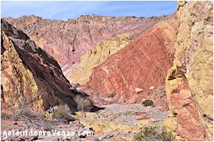
...trailside scenery
Information / Tips:
This adventure would make a great stopover while enjoying the Lake Mead National Recreation Area.
Bring plenty of water / snacks, hat, sunscreen, sunglasses and hiking boots (advised).
Keep an eye out for wildlife (wild horse and burro, Bighorn Sheep, lizards, birds and of course snakes).
DON'T forget your camera.
• Trailhead Parking amenities: None
(vault toilet: 4.6 miles+- North at
the Northshore Summit Trailhead)
• Lower Lovell Wash Hike: not ADA accessible
• Dogs are permitted (on leash)
• No Appreciable Shade
• No Water Available
..........
Rec. Area Hours 24hrs/day, 365days/year
2024 Entry Fee (valid 7 days): $25 vehicle & occ.
Free Entry Days (dates vary by year):
* M. L. King Jr. Day - mid January
* 1st day of Natl. Park Week - mid April
* Great Amer. Outdoors Act - EARLY AUGUST
* Natl. Park Service Birthday - LATE AUGUST
* Natl. Public Lands Day - LATE SEPTEMBER
* Veterans Day - mid November
..........
nearby: Bowl of Fire - Southwest
nearby: Cottonwood Wash
nearby: Northshore Summit
nearby: Redstone
Warning:
This adventure involves travel to a relatively remote area, please refer to the section on desert travel for safety information.
Make sure you have a full tank of gas and a fully pressurized spare tire.
• This route is within an isolated area, don't
expect to see any other hikers, especially
if hiking mid-week
• Be mindful of lightning / flash floods
• Watch for snakes
• NO CELL PHONE COVERAGE
• AVOID THE AREA DURING EXTREME HEAT
• USE CAUTION AROUND NORTHSHORE RD
AND NEAR THE VERTICAL MINE SHAFT
(watch yourself, your kids, dog(s) & others)
• You are responsible for your own safety
Hiking Route Directions:
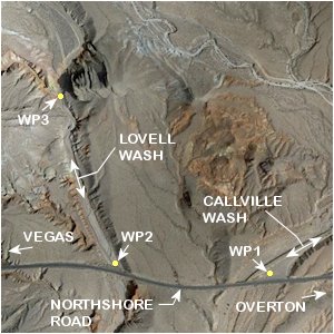
From the parking area (WP1) hike up to and cross Northshore Road, then proceed Southbound (towards Las Vegas) along the roads shoulder (facing traffic) for a total distance of 0.34 miles+- to WP2 which is located within Lovell Wash proper just "upstream" of the concrete box culvert where Lovell Wash crosses underneath the Northshore Rd.
Note: for its entire length Lovell Wash is very steep sided, therefore recross Northshore Rd. and descend into Lovell Wash utilizing a use-trail located on the upstream side of Northshore Rd. just prior to its Southbound crossing of Lovell Wash.
Caution: the posted speed limit on Northshore Rd. is 50mph with many vehicles traveling at higher speeds.
Make sure to watch for oncoming vehicles (both directions) to ensure adequate clearance prior to crossing the road.
Be very aware of traffic: keep an eye on your kids, dogs and other members of your group while hiking along Northshore Rd.
From WP2 hike "upstream" in Lovell Wash, a wide and steep sided wash characterized by typical desert color and interesting geology for 0.35 miles+- to a point (WP3) where very colorful yellow and red formations dominate and a "smaller side wash" intersects Lovell Wash from the Northwest.
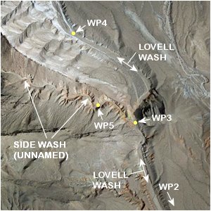
From WP3 bypass the small side wash (for now) and continue "upstream" in Lovell Wash, exiting the yellow and red formations as Lovell Wash arcs Northwesterly, eventually entering an area where the washes steep sides are dominated by white, sandy brown and occasional blue-green formations to WP4, being 0.40 miles+- distant of WP3.
Of Note: from WP4 the route description (as described on this web-page) returns "downstream" back to WP3, however it is recommended to explore further "upstream" thru this colorful area of Lovell Wash, for there are many things to see.
Upon Returning to WP3 hike Northwesterly (upstream) into the aforementioned "smaller side wash" traveling along its narrow winding course thru red, orange, light purple and sandy brown formations to an abandoned Placer Mine and WP5, being 0.14 miles+- distant of WP3.
Caution: abandoned mine sites are hazardous, this particular site although small has a open vertical shaft (reportedly 30-40ft deep) which is "somewhat" protected by dilapidated wire fencing and may be subject to collapse due to undercut walls or unstable soil near its opening.
Do not approach this vertical shaft: watch your kids, dogs and other members of your group in this area as a mishap could prove fatal.
Of Note: from WP5 the route description (as described on this web-page) returns "downstream" back to WP3, however it is recommended to explore further "upstream" thru this small side wash, for there are colorful red formations along its winding course and other things to see.
Once Again at WP3 retrace your route "downstream" thru Lovell Wash to WP2, then Northbound along Northshore Rd. to the Mile Marker #16 parking area and WP1.
..........
Waypoint Sequence (as described above):
WP1-WP2-WP3-WP4-WP3-WP5-WP3-WP2-WP1
..........
Note: it is recommended to utilize internet mapping resources such as aerial photography (not always current) and the provided waypoint positions to visualize your route prior to visiting this area.
Following the route as described above, hikers with a map (include aerial photography) can keep track of their position (more or less).
Keep an eye on your surroundings (look back often) when hiking in this area, utilizing landmarks will help on your return route.
This adventure requires minimal route finding and terrain awareness, inexperienced persons should consider traveling with an experienced person or group.
The use of a handheld GPS unit is recommended, know your GPS device's settings and use.
Remember: you are responsible for your own safety.
..........
Hiking Route Summary (as described):
Distance: 2.46 miles+ (out & back)
* expect actual hiking distances to be greater due
to exploration of each wash or by extending the
route "upstream" of either WP4 or WP5, both of
which are highly recommended
..........
WP1: N36.19659 W114.68784
parking / start hike
WP2: N36.19693 W114.69353
within lovell wash
WP3: N36.20166 W114.69532
lovell wash @ side wash
WP4: N36.20551 W114.69855
lovell wash turnaround
WP5: N36.20243 W114.69734
mine @ side wash turnaround
Note:
See desert travel for GPS Waypoint info
All distances and waypoints are approximate
Driving Directions:
From the intersection of NV-564 (E. Lk. Mead Pkwy.) and NV-167 (Northshore Rd.) within Lk. Mead National Recreation Area head North on Northshore Rd. for 16 miles+- to Mile Marker #16.
Turn Left (Northerly) into a large gravel parking area (WP1) and park immediately adjacent to Northshore Rd.
Note: the parking area has no signage, therefore keep an eye on the "Mile Markers" as you progress Northbound on Northshore Rd.
Return by reversing route.
Approx. 40 miles from central Vegas Strip via I-15 South, I-215 East, NV-564 East (E. Lk. Mead Pkwy.) and NV-167 (Northshore Rd.) to the large gravel parking area (WP1) and the access location for the Lower Lovell Wash adventure (as described above).
