Las Vegas, as we know it today, would be very different without Hoover Dam.
The dam's turbine generators provide electricity to the Vegas area as well as many other communities across the Southwestern United States.
In addition, Hoover Dam impounds the waters of the Colorado River and its tributaries into Lake Mead yielding a reliable water supply to Las Vegas, Phoenix, Los Angeles, San Diego, smaller communities and farms across the region.
Lake Mead's water and the electricity provided by Hoover Dam allowed Las Vegas in particular to develop into, what many consider, an "oasis" in the desert.
Try to imagine Las Vegas without its lavish water features and the neon lights of the Vegas Strip.
Being a true marvel of technology, Hoover Dam makes for an excellent day trip while visiting the Vegas area.
Overview:
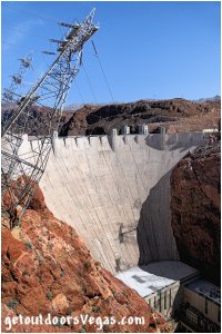
Hoover Dam is a concrete arch-gravity dam, located approx. 30 miles southeast of Las Vegas in Black Canyon on the Colorado River.
Being the second tallest dam in the United States after the Oroville Dam in California, Hoover Dam is very impressive.
At 726 feet tall (foundation rock to the roadway on the crest), Hoover Dam measures 1,244 feet in length along its top and 660 feet thick at its base tapering to 45 feet thick at its crest.
Weighing in at more than 6.6 million tons the dam itself consists of 3.25 million cubic yards of concrete.
Together the dam, powerplant and appurtenant works utilized 4.36 million cubic yards of concrete, enough concrete to pave a 16 foot wide highway from San Francisco to New York City.
The "Boulder Canyon Project Act" was approved on Dec. 21, 1928 and funded on July 7, 1930.
Described as an Act to provide for the construction of works for the protection and development of the Colorado River Basin: specifically to provide hydroelectric power, water storage, irrigation and flood control with a "realized side benefit" of creating jobs during the Great Depression.
Originally planned for construction at Boulder Canyon, geologists determined that Black Canyon (8 miles downstream) was a more suitable site.
Prior to the commencement of construction at the "damsite proper" additional work on 4 key project areas was required:
(1) Boulder City was constructed to house government and contract employees.
Amenities included a state-of-the-art hospital, department store, recreation hall, laundry, school and post office.
Married men and their families lived in cottages, while single men lived in dormitories.
Of Note: Initially, many unemployed poverty stricken and homeless construction men brought their wives and children with them to the Hoover Dam construction site.
Construction of housing had not yet been completed and like so many others during the Great Depression, the workers and their families were forced to live in communities of tents or makeshift lean-tos.
Nicknamed "Rag Town" there was no sanitation with shelters being inadequate for the extreme weather conditions.
It is thought that as many as 100 people including wives and children of the workers died from heat, polluted water or disease.
(2) Construction of 7 miles of 22 foot wide, asphalt-surfaced highway from Boulder City to the damsite.
(3) Construction of 22.7 miles of standard-gauge railroad connecting the Union Pacific mainline (Las Vegas) to Boulder City and an additional 10 miles connecting Boulder City to the damsite.
(4) Construction of a 222 mile-long power transmission line from San Bernardino, California to the damsite (supplying energy for construction).
Damsite construction began Apr. 20, 1931 with the dam, powerplant and appurtenant works completed by Mar. 1, 1936.
Originally referred to as Boulder Dam due to animosity of President Herbert Hoover's handling of the Great Depression it was not until 1947 that Boulder Dam was renamed Hoover Dam.
During the projects time-line an average of 3,500 men were employed with maximum employment of 5,218 men occurring in June 1934.
The "official" number of deaths (industrial fatalities) in the construction of Hoover dam is 96 (contested by other sources), causes ranging from drowning, blasting, falling rocks or landslides, falls from the canyon walls, carbon monoxide poisoning, heavy equipment and truck accidents, etc.
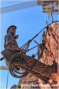
The sculptor Oskar J. W. Hansen's memorial at Hoover Dam stands as a tribute to those workers who died, it reads “THEY DIED TO MAKE THE DESERT BLOOM".
Despite sensationalized stories no workers are entombed in Hoover Dam.
Designers of Hoover Dam placed a high importance on aesthetics and artwork during construction.
Design themes, colors and patterns on the dam's exterior reflect an Art Deco style, inspired by original motifs utilized by Navajo and Pueblo peoples.
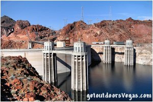
The dam's iconic intake towers combine form and function while diverting water down into the powerful turbine generators.
A "memorial plaza" (artwork by Oskar J. W. Hansen) located just west of the dam "centers" around a pair of bronze statues named "Winged Figures of the Republic" honoring the "aspirations and growth of a nation as it brings life to a dry desert".
The aforementioned Hansen memorial to the workers that died along with other inspirational artworks are on display in the plaza area.
Not to be outdone, the decor inside the passageways of the dam is inspired by motifs of Navajo and Pueblo sand paintings, textiles, baskets and ceramics.
Lake Mead, the reservoir formed by Hoover Dam, was named after Elwood Mead commissioner of the U.S. Bureau of Reclamation (1924-1936).
One of the largest man-made lakes in the world, Lake Mead was for decades the largest artificial lake in the world and is still the largest reservoir "at full pool" in the United States.
At maximum capacity, Lake Mead measures 112 miles long, is 532 feet deep at its greatest depth, has a surface elevation of 1219.6 feet above sea level, a surface area of 247 square miles and contains 26.12 million acre feet of water.
The lake has remained below full capacity since 1983 due to drought and increased water demand, being only 31%+- of "full pool" as of June 2023.
In 2013 Lake Mead fell to second in size behind Lake Powell (second largest U.S. reservoir when both are full).
Currently (as of June 2023) both lakes (combined) are approximately 2/3rds empty (scientists predict neither will probably fill again).
Located "just minutes" from Las Vegas, Lake Mead National Recreation Area is a popular destination for tourists and locals alike.
The Recreation Area includes Lake Mead and Lake Mohave (created by the Davis Dam - construction 1942-1950).
Initially designated as the Boulder Dam Recreation Area, the area was renamed to the Lake Mead National Recreation Area in 1947.
The area that would become Lake Mohave, upon completion of the Davis Dam, was then added.
An Act of Congress in 1964 "officially" designated Lake Mead National Recreation Area as the nations first National Recreation Area.
At 1.5 million acres (1.3 land - 0.2 water) the Lake Mead National Recreation Area is the third largest area administrated by the National Park Service (outside Alaska).
Covering 140 miles+- of the "old" Colorado River Channel the Recreation Area stretches upstream from Davis Dam to the upper reaches of Lake Mead and beyond (full pool), encompassing a wide "swath" of land designated as wilderness areas.
The Hoover Dam / Lake Mead National Recreation Area "complex" attracts 10 million+ visitors a year, being one of the most popular destinations in the National Park System.
Hoover Dam and Davis Dam are administrated by the Bureau of Reclamation.
.....
Lake Mead Natl. Rec. Area map: click here
Lake Mead - Lakeview Overlook:
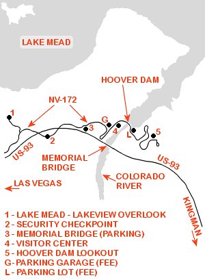
The Lake Mead - Lakeview Overlook parking area is accessed by a paved road terminating 0.25 miles North of NV-172 (see maps below).
The relatively small parking area can "formally" accommodate fewer than a dozen vehicles including 1 ADA parking space (over-sized vehicles may be limited).
Amenities include informational signs and trash receptacles (no restroom facilities).
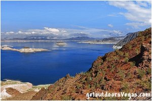
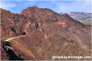
The Lakeview Overlook (considered by many) provides one of the best / easily accessed views of Lake Mead and the surrounding area.
The overlook is a popular stop for travelers visiting Hoover Dam.
Here one can enjoy an outstanding view of Boulder Basin and the deep blue water of Lake Mead, the largest reservoir in the United States.
Also visible (westerly - below the overlook) is an old abandoned railroad tunnel (no access from the overlook).
The tunnel / associated rail-bed is part of the only remaining section (not highly disturbed or flooded) of the historic Hoover Dam Railroad system.
The rail network (approx. 33 miles of track) connected Boulder City, support facilities and the Hoover Dam construction site.
Each tunnel along the line was "over-sized" to accommodate materials and large equipment needed to build Hoover Dam.
Today a rail-trail follows a portion of the old route "snaking" through a total of 5 giant long-abandoned tunnels, offering panoramic views of Lake Mead along the route.
Note: look for Bighorn Sheep in this area.
Hoover Dam By-Pass Project:
The tight switchbacks ascending / descending into the Colorado River canyon and crossing over Hoover Dam had long been a major bottleneck on busy Route 93 linking Las Vegas, Nevada and Kingman, Arizona.
Since Hoover Dam's completion (1935), increasingly heavy traffic (private & commercial) along the 2-lane route had to negotiate these steep / tight turns and dodge hordes of tourists visiting the dam.
As early as the 1960s, officials determined that the US-93 route over Hoover Dam was dangerous and inadequate for projected traffic volumes.
From 1998–2001, officials from Arizona, Nevada, and several federal government agencies collaborated to determine the best route for an alternative river crossing.
In March 2001, the Federal Highway Administration selected the route, which crosses the Colorado River approximately 1,500 feet downstream of Hoover Dam.
After 2001 commercial truck traffic was diverted thru Laughlin, Nevada.
Construction of the bridge approaches began in 2003.
Officially named the Mike O’Callaghan-Pat Tillman Memorial Bridge (2004) in honor of:
Mike O’Callaghan
decorated Korean War veteran
Nevada Governor (1971-1979)
Las Vegas Sun Newspaper (exec. editor)
died Mar. 5, 2004
Arizona State University graduate
left NFL to join the Army (2002)
killed in Afghanistan (friendly fire)
(Apr. 22, 2004 - age 27)
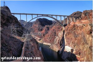
Construction on the Mike O'Callaghan–Pat Tillman Memorial Bridge proper started Feb. 14, 2005, completed Oct. 14, 2010, opened to pedestrians Oct. 16, 2010 and vehicle traffic Oct. 19, 2010.
Bridge statistics: first concrete-steel composite arch bridge built in the United States, construction cost $240 million (project total), 1,900 feet in length, 1,060 foot arch span (widest in the Western Hemisphere), 890 feet above the Colorado River (second highest bridge in the United States).
Interesting Fact: Driving the bridge affords no views of Hoover Dam or the Colorado River.
Engineers designed tall crash barriers (parapets) along the bridge to (1) avoid having sight-seers slow down or stop on the bridge (2) mitigate high winds that funnel through the canyon.
In fact high profile vehicles are directed to the inside 2 lanes of the 4 lane wide bridge while crossing.
Bottom line: no need drive the bridge just for the scenery.
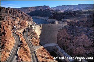
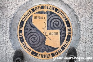
With no views of Hoover Dam or the Colorado River while driving the Mike O'Callaghan–Pat Tillman Memorial Bridge, engineers came up with a better way to enjoy the "missing" scenic view.
A pedestrian walkway was built along the Northern (upstream) side of the bridge giving visitors a safe and absolutely stunning view of Hoover Dam and the surrounding area.
The memorial bridge parking lot provides access to the bridge's pedestrian walkway.
From the parking lot a concrete pathway begins at a plaza area with informational panels.
The pathway requires negotiating 70 steps which can be bypassed by a series of ramps built for wheelchairs.
Once atop the stairs / ramps continue thru 4 circular plazas (somewhat shaded) with concrete benches and additional panels detailing the bridge's construction and other topics.
Exiting the plaza area the pedestrian walkway begins.
At 890 feet above the Colorado River the walkway has a shoulder-high railing made from large diameter steel tubing, reassuring for most people afraid of heights.
The view of Hoover Dam (and the surrounding area) is very impressive, as is looking straight down to the river below.
It takes about 7-8 minutes at a brisk pace to walk the entire 1,900 foot length of the bridge (one way).
On the walkway brass plaques describe key facts about the bridge and its construction.
A brass medallion commemorates the bridge's namesakes (O'Callaghan and Tillman).
Other medallions mark the center of the bridge's arch and the Nevada / Arizona state line.
Enjoy your time on the pedestrian walkway, the view is stunning, the technology is amazing and the experience is unforgettable.
In addition to the plaza area (mentioned above), the memorial bridge parking lot has around 5 dozen regular parking stalls, 6 ADA stalls, 3 large RV / Bus spaces for parking, ADA compliant restrooms and trash receptacles.
Hours: Dawn to Dusk.
Visitor Center:
The 44,000 square foot Hoover Dam Visitor Center offers educational exhibits, interactive displays and films about the dam and its construction.
The center juts out from a canyon wall which overlooks Hoover Dam, the Colorado River and the Mike O’Callaghan-Pat Tillman Memorial Bridge.
The Bureau of Reclamation decided to build this "new" visitors center (opened June 1995) after officials became concerned that tourists were parking a mile away, then crossing a two-lane road to tour the original exhibit hall and the dam's powerhouse.
Today, visitors are able to walk into the center from a multi-level parking garage by utilizing a bridge built under the highway.
Visitors must pass thru security screening to access the Visitor Center.
Ticket sales for access to the Visitor Center can be purchased online or onsite.
Pre-purchased Visitor Center tickets can be upgraded at the Visitor Center for either Dam Tour (if space is available).
.....
Adults (age 4+) $10
Children (ages 0-3) FREE
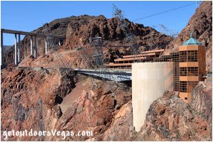
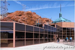
Hoover Dam Tours:
Ticket sales for Hoover Dam Tours can be purchased online or onsite (depending upon the tour) at the Visitor Center.
Note: if a tour is purchased the tour includes access to the Visitor Center.
Tours run throughout the day with the latest tour commencing at approx. 4:00pm.
Listed below are specifics for each of the two available tours (as of 07/2023):
(1) Guided Dam Tour Package includes:
(ticket purchases onsite only)
• 10-minute movie on history of Hoover Dam
• 1-hour tour of dam
• visit historic tour tunnels
• visit the inspection tunnels at the center of
the dam
• view the Colorado River thru the inspection
ventilation shaft
• ride original elevator to the top of the dam
• includes areas provided in the Guided
Powerplant Tour
• includes access to the Visitor Center and
observation deck
Note: wheelchairs allowed
Adults (ages 8+) $30
(must be 8 years of age or older)
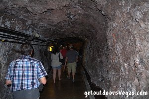
(2) Guided Powerplant Tour Package includes:
(ticket purchases onsite or online)
• 10-minute movie on history of Hoover Dam
• 30-minute tour of dam
• elevator ride into the dam
• walk thru original constructions tunnels
• viewing platform overlooking a 30-foot
diameter penstock pipe
• viewing platform overlooking eight
Nevada turbine generators
• includes access to the Visitor Center
and observation deck
• pre-purchased tickets can be upgraded to
the Guided Dam Tour at the Visitor Center
(if space is available)
Note: wheelchairs, motorized scooters
and strollers are allowed
Adults (ages 11+) $15
Juniors (ages 4-10) $10
Children (ages 0-3) FREE
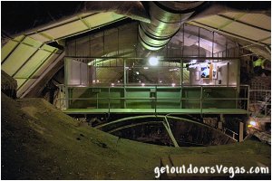
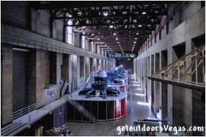
Note: Hoover Dam Tours are NOT RECOMMENDED for anyone who suffers from claustrophobia (confined spaces - tunnels, elevator) or for anyone who has a pacemaker or defibrillator (turbine generators emit electromagnetic fields).
Hoover Dam Lookout:
The Hoover Dam Lookout parking lot lies approx. 1 mile East of the dam.
The lot has almost 3 dozen regular parking and 4 ADA stalls (no over-sized parking).
Note: the parking lot is only accessible to Westbound traffic (as you pass by take a quick glance for available parking).
To access the parking lot one must continue to roads end (0.2 mile+- detour) and a large parking / turnaround area (tour bus drop-off site): can be utilized for "overflow" and over-sized parking for the Hoover Dam Lookout.
This "teardrop shaped" parking / turnaround area (no views of dam) provides almost 2 dozen parking stalls (no ADA parking) with limited over-sized parking available.
A sidewalk connects the parking / turnaround area (no wheelchair ramps) with the Hoover Dam Lookout (a 500 foot+- walk with a slight elevation gain / loss).
From the turnaround area ADA access with assistance is possible: use your own discretion.
Reversing course from the turnaround area provides access to the Hoover Dam Lookout parking lot and a Westerly return to the Vegas area.
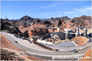
While visiting Hoover Dam a trip up to the Hoover Dam Lookout is a must.
The "lookout" parking lot (210 feet+- above the crest / top of Hoover Dam) provides a unique view of the dam and surrounding area (Black Canyon of the Colorado River).
Views from here overlook the dam itself (back upstream side), the Arizona and Nevada intake towers and spillways, power-line towers, road system switchbacks rising from the dam on the Arizona side, viewpoints, Visitor Center, Nevada side parking garage and the Mike O'Callaghan-Pat Tillman Memorial Bridge.
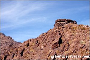
Of Interest: a WWII era pillbox (built Dec. 1941 - not accessible to the general public) is visible above and North of the parking lot on a bluff overlooking Hoover Dam.
Constructed immediately after the bombing of Pearl Harbor the pillbox incorporated a 270 degrees viewing window with 13" thick concrete walls, floor and ceiling and a natural rock camouflage excavated from the surrounding area.
The structure was "manned" (immediately after construction) by the U.S. Army to "defend" Hoover Dam during uncertain times at the beginning of the United States involvement in WWII (abandoned late 1942 / early 1943).
In addition to parking mentioned above the Hoover Dam Lookout has a small gift shop (ADA accessible) with a shaded outdoor seating area and tables.
Souvenirs, snacks and beverages are available for purchase (can be pricey).
A shaded gazebo with chairs, tables, information signs and viewing scopes occupies one corner of the parking lot.
Other amenities include trash receptacles and "Porta-Potty" style restrooms (ADA accessible).
Parking (see map below):
NOTE: PARKING AREAS FILL UP ON BUSY DAYS: arrive early or later in the day if you can.
.....
The parking garage (0.7 miles East of the memorial bridge parking area - $10.00 fee) is open from 8am-5:15pm.
Complimentary parking is offered for those with accessibility needs (show your disabled person sticker / placard to the garage attendant).
Motorhomes and other high clearance vehicles are restricted (no greater than 10.5 feet high and 23 feet long).
Parking for high clearance (over-sized) vehicles is available on the Arizona side of the dam.
The multi-level parking garage (shaded stalls available - nice on a hot day) is the most convenient parking option for visiting Hoover Dam.
The garage offers a breathtaking (panoramic) view from Hoover Dam to the by-pass bridge and beyond.
At street level there are restrooms (near the garage elevator), a gift shop (open 8am-5pm daily), cafe (open 8:30am-5pm daily - indoor seating available) and patio area with shaded tables.
The cafe is the only choice for food or drinks in the immediate vicinity of Hoover Dam (can be pricey - think about bringing food, snacks, water with you).
From the garage area it is 300 feet+- to the Visitor Center, 500 feet+- to the dam: short walks with a slight uphill climb on return.
The parking lot (0.5 miles East of the parking garage on the Arizona side of Hoover Dam - $10.00 fee) is open from 8am-4pm.
There is an adequate number of parking stalls (some provide shaded cover) and ADA parking.
Complimentary parking is offered for those with accessibility needs (show your disabled person sticker / placard to the attendant).
Limited parking is available for high profile (over-sized) vehicles in non-covered "marked" spaces.
This parking lot affords "quick" / level walking access to the dam (500 feet+-) but requires a 0.5 mile+- walk to the Visitor Center, gift shop and cafe area.
There are no amenities at the parking lot, closest restrooms are atop the dam on the south (downstream) side (women: near east end / men: near west end).
Continuing East and uphill from the previously described parking lot are 5 additional viewpoint / parking areas and the Hoover Dam Lookout parking lot (no fees).
Of these the first four lots (no over-sized vehicle parking) could be considered to have access to the dam (elevation well above dam - stairs / exposure to traffic).
The fifth viewpoint / parking area is typically utilized by most individuals as a viewpoint overlooking the dam / surrounding area and can accommodate over-sized vehicles.
Just East and uphill of the fifth viewpoint / parking area is the Hoover Dam Lookout parking lot (no over-sized parking).
Beyond (East of) the Hoover Dam Lookout area, at the end of the road is a large parking / turnaround area (tour bus drop-off site) that can be utilized for "overflow" and over-sized parking for the Hoover Dam Lookout (no views of the dam).
Note: the third viewpoint / parking area and the Hoover Dam Lookout are only accessible to Westbound traffic.
Of this group of viewpoint / parking areas all have trash receptacles, some have interpretative signs and only the Hoover Dam Lookout has "Porta-Potty" style restrooms.
Information / Tips:
HOOVER DAM THROUGH-TRAFFIC PROHIBITED:
vehicles, including those crossing Hoover Dam to visit Arizona viewpoints / concessions must exit the area via Nevada.
.....
Hours: 5am-9pm, 365days/year
Visitor Center: 9am-5pm
(closed Thanksgiving & Christmas)
Fees: parking, Visitor Center, tours (as of 07/2023)
Food / Drink: water bottles allowed anywhere
(no food / drink on dam or in buildings)
Animals: disability service animals welcome
(pets not allowed on dam or in buildings)
(no animals left unattended in vehicles)
Weapons / Knives: not allowed in buildings
(any type or size including pocket knives)
Drones: prohibited on Hoover Dam property
Inter-agency Passes: not accepted
.....
nearby: Black Mtn. Overlook
nearby: Hemenway Park
nearby: Historic R.R. Tunnel Trail
nearby: Mendenhall Scenic Overlook
nearby: Nature Discovery Trail
Warning:
Please refer to the section on desert travel for safety information.
AVOID THE AREA DURING EXTREME HEAT:
make sure you have a full tank of gas, a fully pressurized spare tire and plenty of water.
Remember you are responsible for your own safety.
Directions:
From the I-15 (Las Vegas Fwy) interchange with W. Flamingo Rd. proceed South on I-15 for just over 3 miles to Exit #34.
Exit onto the Exit #34 offramp, continue Southerly then Easterly (utilizing the left 2 lanes) eventually merging onto Eastbound I-215.
Travel Eastbound on I-215 for just over 10 miles taking Exit #1 (stay in right lane) toward Boulder City (US-93 / I-11).
Travel Southbound on US-93 / I-11 for just over 20 miles to Exit #2 (US-93 Business / Boulder City / Hoover Dam).
Exit onto the Exit #2 offramp and follow to a Traffic Circle.
Utilizing the outside lane of the Traffic Circle (traveling 3/4 around) head Northbound (underneath US-93 / I-11) to the intersection with the Hoover Dam Access Rd (NV-172).
Turn right (Eastbound) on NV-172 traveling 1.3 miles to the turnoff for the Lake Mead - Lakeview Overlook (on your left).
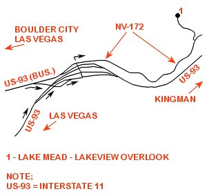
From the Lakeview Overlook turnoff continue Eastbound on NV-172 for 0.3 miles to a Security Checkpoint which all visitors must pass thru.
All vehicles entering the dam site are subject to inspection by security personnel, which could delay your visit dependent upon traffic volume.
Visitors declining vehicle inspection will not be permitted access beyond the checkpoint.
Once thru the checkpoint continue Eastbound on NV-172 for 0.5 miles to the Mike O'Callaghan-Pat Tillman Memorial Bridge parking area (on your right).
From the memorial bridge parking area turnoff continue Eastbound on NV-172 for 0.7 miles to access the first of two paid parking areas (parking garage - on your left).
From the first parking area access point continue Eastbound on NV-172 (crossing over Hoover Dam and into Arizona - WATCH FOR PEDESTRIANS) traveling 0.5 miles to the second of two paid parking areas (on your left - BLIND CURVE: BE CAUTIOUS OF PEDESTRIANS / TRAFFIC).
Note: NV-172 ends at the Nevada / Arizona border (atop the dam) transitioning to the Kingman Wash Access Road.
From the second parking area continue Eastbound on Kingman Wash Access Road, uphill past five additional viewpoints / parking areas (no fees) and the Hoover Dam Lookout parking area (no fees - on your left - left turn not permitted) for about 1 mile to roads end and a large parking / turnaround area.
From roads end reverse course driving 500 feet+- to access the Hoover Dam Lookout.
From the Hoover Dam Lookout continue Westbound backtracking along your former route to return to the Vegas area.
