Historic R.R. Tunnel Trail
Lk. Mead Natl. Rec. Area
Of the millions of people that have visited Hoover Dam over the years relatively few stop to see the remains of the rail-lines that were constructed to build the dam.
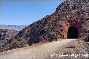
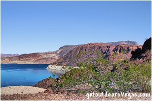
The Historic Railroad Tunnel Trail (as described on this web-page) offers an interesting walk (or bike ride) thru five "oversized" tunnels with fantastic views of Lake Mead and the surrounding mountains.
This 4.5 mile+- (out & back) trail is all that remains of a 30-mile rail-system that was built to haul "oversized" equipment and materials to the Hoover Dam construction site.
The remainder of the rail-system either lies underwater (flooded by Lake Mead) or has been significantly altered or obliterated over time.
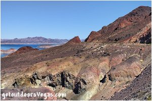
Due to the inaccessibility of the Hoover Dam construction site rail-lines were needed to connect Las Vegas, Boulder City and the dam site.
A contract to build the dam was awarded (1931) to a consortium of firms called Six Companies.
In addition to a rail-line connecting Las Vegas and Boulder City which was built and operated by the Union Pacific Railroad, the project required rail-lines from Boulder City to cement mixing plants, quarries and other facilities.
These aforementioned segments of the rail-system were built by Six Companies and the federal government.
The Historic Railroad Tunnel Trail occupies a segment (built by the federal government) that ran from Boulder City down Hemingway Wash to the rim of Black Canyon.
The federal government section required 10 miles of track (over a 6.7 mile distance) to negotiate the terrain and a 1,100 foot vertical drop to the canyon rim of which 2.25 miles+- (one way) are represented by the Historic Railroad Tunnel Trail (as described below).
The heavily used federal government section saw significantly less usage after Hoover Dam's completion (1935) and continued to be utilized by dam workers until 1961 when the last generator for the dam was installed at the power plant.
The tracks were dismantled in 1962 and the site was nominated to the National Register of Historic Places in 1984.
The abandoned rail-line was designated by the U.S. Department of Interior as a National Recreation Trail in 2015.
In 2016 the Historic Railroad Trail was refurbished to fix erosion issues and a more accessible surface was laid down.
In 2018 (and again in 2019) shipping containers were inserted into two of the tunnels to protect visitors from rockfall hazards and remain in place today.
Today the Historic Railroad Tunnel Trail provides visitors with a glimpse of history, an "unusual" outdoor experience and magnificent scenery.
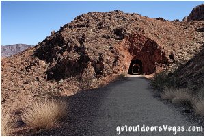
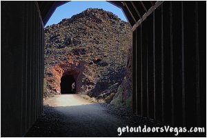
...trailside scenery
Information / Tips:
Bring plenty of water / snacks, hat, sunscreen, sunglasses and comfortable shoes.
Bicycles are permitted.
Dogs (on leash) are permitted.
Don't forget your camera.
• Trailhead amenities:
information kiosks
vault toilet
trash receptacles
ADA parking (2 spaces)
18 formal parking spaces
lot can hold up to 50+- cars
oversized parking restricted
(sharp curves in parking lot)
Note: overflow parking is available at the Lake Mead Visitor Center located 0.23 miles+- Southwest of the Trailhead Parking Area.
Adds 0.43 miles+- and 180 feet+- in elevation loss / gain (round trip) to hike.
The visitor center (full amenities) is open seven-days a week from 9am - 4:30pm (parking lot is always open).
.....
nearby: Black Mtn. Overlook
nearby: Hemenway Park
nearby: Hoover Dam
nearby: Mendenhall Scenic Overlook
nearby: Nature Discovery Trail
Warning:
This adventure involves travel to a relatively remote area, please refer to the section on desert travel for safety information.
• Be careful around drop-offs / steep slopes
(watch your kids)
• Be mindful of lightning / flash floods
• Watch for snakes
• AVOID THE AREA DURING EXTREME HEAT
• You are responsible for your own safety
Trail Directions:
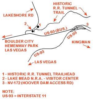
From the trailhead (near two information kiosk) in the Southwesterly side of the Historic R.R. Tunnel Trail Parking Area walk Southerly 120 feet+- along a concrete path (towards the Visitor Center) to a dirt trail that branches off to the left.
Turn left (Easterly) onto the rock lined dirt trail traveling 900 feet+- and merge with the Historic Railroad Trail.
Continue Easterly along the Historic Railroad Trail traveling 125 feet+- to a metal gate (blocks vehicular access) which if locked hikers can by-pass.
Leaving the metal gate, continue Easterly on the Historic Railroad Trail for 0.50 miles+- to an intersection with a "short cut trail" descending from a trailhead located at the Casino Parking lot above and South of the Historic Railroad Trail.
Although not described on this web-page, the "short cut trail" cuts 0.83 miles+- off the total hike but requires a "significant" descent / assent over its 1,600 foot+- length (one-way).
From the aforementioned intersection, continue Easterly on the Historic Railroad Trail for 0.27 miles+- to an area (on the right) where large concrete powerhouse "placeholder" plugs were "dumped" after being removed during the Hoover Dam turbine installation process.
Continuing Easterly on the Historic Railroad Trail for 0.27 miles+- hikers reach the first of five "oversized" railroad tunnels.
Thru and beyond the first tunnel the Historic Railroad Trail passes thru four additional tunnels, exiting tunnel five approx. 0.85 miles East of tunnel one.
Upon exiting tunnel five continue along the Historic Railroad Trail for 680 feet+- to a Bureau of Reclaimation Rest Area (amenities include: shaded picnic tables, information signs, water fountain, emergency phone, vault toilet, trash cans) and the end of this trail description.**
Return by reversing route.
** From the Bureau of Reclaimation Rest Area
hikers can continue Easterly along the trail
which runs around the back of the highway
maintenance yard and down the canyon to
Hoover Dam (1.72 miles+- one way).
Note: not described on this web-page
.....
Trail Summary (as described above)
Distance: 4.5 miles+- (out & back)
Elevation Gain: minimal
ADA accessible: use your own judgment
Driving Directions:
From the I-15 (Las Vegas Fwy) interchange with W. Flamingo Rd. proceed South on I-15 for just over 3 miles to Exit #34.
Exit onto the Exit #34 offramp, continue Southerly then Easterly (utilizing the left 2 lanes) eventually merging onto Eastbound I-215.
Travel Eastbound on I-215 for just over 10 miles taking Exit #1 (stay in right lane) toward Boulder City (US-93 / I-11).
Travel Eastbound on US-93 / I-11 for just over 20 miles to Exit #2 (US-93 Business / Boulder City / Hoover Dam).
Exit onto the Exit #2 offramp and follow to a Traffic Circle.
Utilizing the outside lane of the Traffic Circle (traveling 3/4 around) head Northbound (underneath US-93 / I-11) to the intersection of US-93 (Bus.) and the Hoover Dam Access Rd (NV-172).
Turn left (Westbound) onto US-93 (Bus.) traveling 1.5 miles+- to the turnoff for Lakeshore Rd.
Turn right (Northbound) onto Lakeshore Rd. traveling 0.4 miles+- to the Historic R.R. Tunnel Trail Parking Area and trailhead (on your right).
Approximately 38 miles from the central Vegas Strip to the Historic R.R. Tunnel Trail Parking Area and trailhead.
Return by reversing route.
Note: the Historic R. R. Tunnel Trail parking area can be accessed from either Boulder City via US-93 (Bus.) or thru the Lk. Mead Natl. Rec. Area (entry fee) via Lakeshore Road: both alternatives are not described on this webpage.
