Black Mtn. Overlook
River Mtns. - Boulder City, Nv.
Overview:
The Black Mtn. Overlook Trail is located in the River Mountains just North of Boulder City, Nv.
The River Mountains are a small, but spectacular and colorful mountain range made of volcanic rock.
Of the two volcanoes identified in the River Mountains a Composite Volcano lies just North of Boulder City.
Composite Volcanoes are typically "cone" shaped and erupt "sticky" lava, often leading to explosive eruptions.
The second volcano, a Shield Volcano lies in the northern part of the River Mountains and is characterized by a broad "shield" shaped profile typically erupting "fluid" lava with non-explosive eruptions.
Over time both volcanoes have been tilted, cut by numerous faults, eroded and broken down into the jumble of "rocky" summits seen today making the original volcanoes (now dormant / extinct) very difficult to recognize.
The River Mountains rise to an elevation of 3,789 feet (summit of River Mountain) with the "summit" of Black Mtn. Overlook (elev. 3,525 feet+-) being a great place to sit, relax, and take in the scenery.
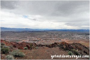
To the Northwest is Las Vegas and the Strip, to the Northeast is Lake Mead, to the South is Boulder City, with other mountain ranges (visible in all directions) stretching to the horizon.
Vegetation is typical Mojave Desert Scrub dominated by Creosote Bush and other common plants.
In addition to desert wildlife common to the area, the River Mountains are well known for their exceptional Bighorn Sheep and Desert Tortoise habitat.
Black Mtn. Overlook Hiking Options:
• from Boulder City
(not described on this web-page)
5.2 miles+- out / back
1,100 feet+- elevation gain then loss
• from the Black Mtn. Overlook Parking Area
(as described on this web-page)
1.5 miles+- out / back
trail elev. profile: see below
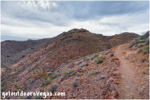
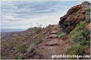
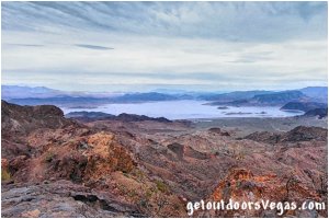
...trailside scenery
Information / Tips:
Bring plenty of water / snacks, hat, sunscreen, sunglasses and hiking boots (advised).
Make sure you have a full tank of gas and a fully pressurized spare tire.
Dogs are allowed on leash.
DON'T forget your camera / binoculars.
..........
• Black Mtn. Overlook Parking amenities: none
• Black Mtn. Overlook amenities:
informational signs & seating bench
• Fees: none
• Black Mtn. Overlook Trail: not ADA accessible
• No Shade
• No Water Available
..........
nearby: Hemenway Park
nearby: Historic R.R. Tunnel Trail
nearby: Hoover Dam
nearby: Mendenhall Scenic Overlook
nearby: Nature Discovery Trail
Warning:
This adventure involves travel to a relatively remote area, please refer to the section on desert travel for safety information.
• Bicycles are allowed on portions of this trail
system, prohibited between WP6 and WP8
• Watch for snakes
• Be mindful of lightning / high winds
• AVOID THE AREA DURING EXTREME HEAT
• You are responsible for your own safety
Trail Directions:
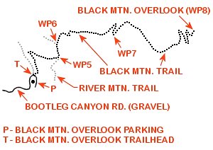
From the North-Northeast corner of the Black Mtn. Overlook Parking Area (waypoint T) bear right heading Northeasterly downslope (thru an abrupt switchback) for 0.14 miles+- to a trail intersection with the River Mtn. Trail / Black Mtn. Trail and WP5.
Bear left (Northerly) from WP5 traveling along the Black Mtn. Trail for 0.03 miles+- to a second trail intersection and WP6.
From WP6 bear right (Easterly) continuing along the Black Mtn. Trail "proceeding upslope" for 0.21 miles+- to a switchback / use-trail intersection and WP7.
From WP7 travel along the use-trail 50 feet+- (Southerly) to a nice overlook of Boulder City below.
Back at WP7 continue along the Black Mtn. Trail (Easterly) for 0.36 miles+- to WP8 and the Black Mtn. Overlook.
Return by reversing route.
..........
Trail Elev. Profile:
waypoint T to WP5: -94 feet+-
WP5 to WP6: -27 feet+-
WP6 to WP7: +75 feet+-
WP7 to WP8: +183 feet+-
..........
WP1: N35.96957 W114.85493
Boulder City Pkwy. & Yucca St.
WP2: N35.97372 W114.85696
Yucca St. & Industrial Rd.
WP3: N35.97753 W114.84932
Industrial Rd. & Canyon Rd.
WP4: N35.98386 W114.86233
Bootleg Canyon Rd. - end of pavement
P: N35.99883 W114.86107
trailhead parking
T: N35.99907 W114.86103
Black Mtn. Overlook Trailhead
WP5: N35.99973 W114.85996
trail junction
WP6: N36.00014 W114.86006
trail junction
WP7: N36.00062 W114.85750
overlook
WP8: N36.00061 W114.85392
Black Mtn. Overlook
Note:
See desert travel for GPS Waypoint info
All distances and waypoints are approximate
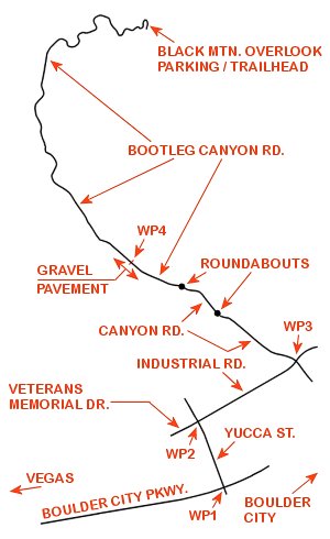
Driving Directions:
From the I-15 (Las Vegas Fwy) interchange with W. Flamingo Rd. proceed South on I-15 for just over 3 miles to Exit #34.
Exit onto the Exit #34 offramp, continue Southerly then Easterly (utilizing the left 2 lanes) eventually merging onto Eastbound I-215.
Travel Eastbound on I-215 for 10.3 miles+- taking Exit #1 (stay in right lane) toward Boulder City (US-93 / I-11).
Travel Eastbound on US-93 / I-11 for 7.1 miles+- to Exit #15B (US-93 Business / Boulder City Pkwy).
Exit onto the Exit #15B offramp, continuing Southerly then Easterly (thru the interchange) eventually merging onto Boulder City Pkwy.
Travel Eastbound on Boulder City Pkwy. for 3.1 miles+- to the intersection of Boulder City Pkwy. / Yucca St. and WP1.
Turn Left (Northerly) onto Yucca St. traveling 0.3 miles+- to the intersection of Yucca St. / Industrial Rd. and WP2.
Turn Right (Easterly) onto Industrial Rd. traveling 0.5 miles+- to the intersection of Industrial Rd. / Canyon Rd. and WP3.
Turn Left (Northerly) onto Canyon Rd. traveling a total distance of 0.6 miles+- (straight thru two roundabouts) to a point where Canyon Rd. transitions into Bootleg Canyon Rd.
Continue Northerly on Bootleg Canyon Rd. for an additional 0.3 miles+- to a point where the pavement transitions to gravel and WP4.
Note 1: from WP4 the gravel section of Bootleg Canyon Rd. is graded but can be rough (use your own discretion when traveling this portion of the route).
Note 2: at WP4 the Bootleg Canyon Park Trailhead (on your right) offers picnic facilities, informational signs and restroom facilities (last chance - no amenities at Black Mtn. Overlook Trailhead).
From WP4 continue up the "now gravel" Bootleg Canyon Rd. 1.8 miles+- to the Black Mtn. Overlook Parking Area and Trailhead.
Return by reversing route.
Approximately 29.5 miles from central Vegas Strip to Trailhead Parking.
