Valley of Fire
Section Index:
Valley of Fire - Overview:
Valley of Fire is Nevada's oldest state park (dedicated in 1935).
Over 40,000 acres in size, the park although big, has an intimate feel to it.
This unique geological area derives its name from red sandstone formations (formed from shifting sand dunes 150 million years ago) which exhibit complex uplifting, faulting and extensive erosion.
These features, which are the centerpiece of the park's attractions, often appear to be on fire when reflecting the sun's rays.
Elevation within the park varies between 2,000 and 2,600 feet with sandstone formations at higher elevations transitioning from predominantly red to rainbow mixtures of reds, whites, yellows, pinks and purples.
Throughout the park wind and rain have "carved" the rock into a playground of fantastic shapes.
Alcoves, arches, crevices, eroded faces of people and animals: with a diversity of color are all around you.
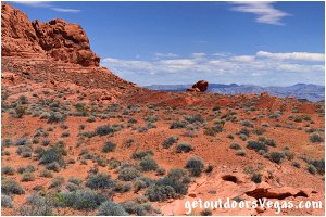
The parks plant community is dominated by widely spaced creosote bush, burro bush, and brittlebrush.
Several cactus species including beavertail, hedgehog and cholla are common.
The springtime bloom of cactus, desert marigold, indigo bush and desert mallow are often spectacular.
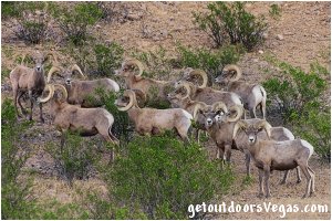
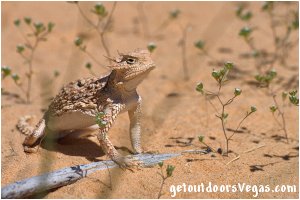
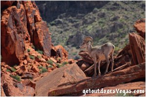
Resident birds include the raven, house finch, sage sparrow and roadrunner. Migrant birds also pass through the park. Many species of lizards (which are commonly seen) and snakes (occasionally seen - be aware when hiking) are in the park. The desert tortoise is a rare species (protected by state law) and if you see one consider yourself lucky. There are Bighorn sheep, coyote, kit fox, black-tailed jackrabbit, spotted skunk and antelope ground squirrel present. Most desert animals are nocturnal and not frequently seen (best chance early morning / evening).
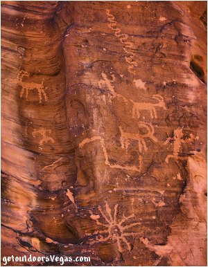
Prehistoric users (approximate occupation - 300 B.C.E. to 1150 C.E.) of Valley of Fire included the Basket Maker people and later the Anasazi Pueblo farmers.
Their visits involved hunting, food gathering and religious ceremonies, although scarcity of water would have limited the length of their stay.
Fine examples of rock art left by these ancient peoples can be found at several sites within the park.
The park is located in the northern part of the Mojave Desert of southern Nevada, about 50 miles northeast of Las Vegas. This area exhibits low desert conditions with summer highs exceeding 100° Fahrenheit (occasionally near 120°). Winters are mild with temperatures ranging from freezing to 75° Fahrenheit. Average annual rainfall is 4 inches, coming in the form of light winter showers and summer thunderstorms. Spring and fall are the preferred seasons for visiting the Valley of Fire.
Valley of Fire Highway:
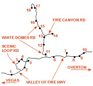
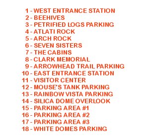
The Valley of Fire Hwy. is the main east / west route within the state park. From I-15 the highway travels easterly through Valley of Fire ending at the Northshore Rd. where one either turns north to Overton, Nv. or south (requires a toll / entry fee) through Lk. Mead National Rec. Area towards Vegas and Hoover Dam.
From I-15 it is 14.5 miles to the Valley of Fire West Entrance Station (see directions below).
Just shy (0.3 miles) of the West Entrance Station is the westerly most of Valley of Fire's two "formal" entrance signs.
The West Entrance Station (when manned) allows the visitor to ask questions, obtain information and pay the entrance fee ($10/day Nevada residents - $15/day non-residents - Nov. 2021).
Other amenities include a small parking area, restroom facility (ADA accessible) and a combination information / shaded platform (nice introductory view of the park).
When unmanned, a self pay-station sits next to the viewing platform (have exact change and a pen / pencil - just in case).
Continuing east from the West Entrance Station (set your odometer - mileage accumulates from the West Entrance Station) the highway descends into the valley towards the westerly most red sandstone formations and after 0.9 miles meets the westerly most access to the Scenic Loop Rd. (on your left - all weather gravel portion).
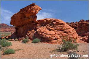
At 1.2 miles east of the West Entrance Station is the parking area (on your right) for the "Beehives".
A fun place to explore, this area demonstrates "geologic cross bedding" (layers deposited over time) and the effects of wind and water erosion.
At 1.8 miles east of the West Entrance Station is the intersections of 2 roads.
To your right is an all weather gravel road which leads to a parking area (0.2 miles) with nice panoramic views and a short loop trail with informational signs and examples of petrified logs (protected by chain link fencing).
Although interesting, one might consider bypassing this exhibit if pressed for time.
Back on the Valley of Fire Hwy. the second of the 2 previously mentioned roads (on your left) is the easterly most access of the Scenic Loop Rd. (paved portion).
At 3.7 miles east of the West Entrance Station is the intersection with the White Domes Rd. (on your left - leads to the Visitor Center and northern sections of the park).
Continuing east on the Valley of Fire Hwy. (4.4 miles east of the West Entrance Station) is the Seven Sisters Picnic Area (on your right).
This area provides a relaxing stop with shaded picnic tables within an area of fantastic red rock formations which are easily accessible.
At a distance of 5.6 miles east of the West Entrance Station is a paved road (to your left - 0.3 miles) leading to The Cabins.
To your left as you exit towards The Cabins is a huge isolated boulder known as Lone Rock (accessed by a short gravel road) that looks as if it might tip over at any moment.
A picnic table has been placed "under" the bolder providing a partially shaded stop with great views of the surrounding area.
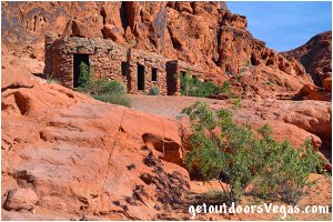
The Cabins (two buildings - three small rooms) were built from native sandstone in the mid 1930s (soon after Valley of Fires designation as a state park) by the Civilian Conservation Corps (CCC).
The CCC did similar work throughout the nations state / federal park systems and other remote regions of the United States during the Great Depression.
Each room has its own door, window and fireplace and could be considered rustic at best.
Used to shelter campers and travelers visiting the park the cabins are now preserved as a reminder of the work accomplished by the CCC.
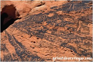
Behind the cabins is a rock art panel from the areas prehistoric visitors.
Now a picnic area with parking, shaded tables and a restroom facility (ADA accessible), this area is popular place for exploration and photography.
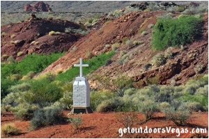
Back on Valley of Fire Hwy. the Clark Memorial (on your right - 6.4 miles east of the West Entrance Station) tells of a war veteran who died near this location in 1915.
Today a memorial cross (erected June 1949 by citizens of Overton, Nevada) lies about 150 feet south (to your right) of the road.
An information plaque reads as follows:
"JOHN J. CLARK WAS BORN IN CANADA IN 1844.
HE ENLISTED AS A PRIVATE IN COMPANY F OF THE NEW YORK INFANTRY IN 1862, SERVING ACTIVELY IN THE CIVIL WAR.
AFTER BEING SHOT IN THE HAND AND CONTRACTING TYPHOID FEVER, HE WAS HONORABLY DISCHARGED 6 MARCH 1863 AS A SERGEANT IN COMPANY B OF THE NEW YORK CALVARY.
FOLLOWING HIS DISCHARGE, SERGEANT CLARK EMIGRATED TO SOUTHERN CALIFORNIA.
WHILE TRAVELING FROM BAKERSFIELD TO SALT LAKE CITY ON A BUCKBOARD, HE STOPPED NEAR THIS SPOT, TIED HIS HORSE TO THE BACK OF THE WAGON AND WANDERED AROUND, POSSIBLY LOOKING FOR WATER.
EVENTUALLY, HE CRAWLED UNDER HIS BUCKBOARD AND DIED, PRESUMABLY FROM THIRST, SEVERAL DAYS BEFORE HIS BODY WAS FOUND 30 JUNE 1915."
Note: For you Star Trek fans, you can check out the metal bridge on which Kirk fell to his "death" in the Generations movie.
The bridge is a short 3-4 minute walk along mostly level ground.
From the Clark Memorial turnout, cross the Valley of Fire Hwy. and walk (approx. 800 feet) along a dirt road / trail that heads northeasterly.
Take a right at an intersecting dirt trail and walk (approx. 150 feet) to the metal bridge.
Return by reversing route.
The actual filming location was in the vicinity of the Silica Dome Overlook parking area.
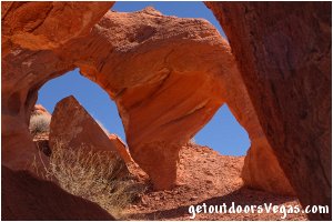
At a distance of 6.7 miles east of the West Entrance Station a pullout on your right (Arrowhead Trail Parking) gives visitors access to Arrowhead Arch (see photo above).
Arrowhead Arch itself can be seen (about 300 feet down the trail) from the trail-head.
The red sandstone hills upslope and to your left along this trail "hide" all kinds of exploration / photographic opportunities.
The Arrowhead Trail Parking area is a good place to begin an easterly exploration (note: no established trails) of the south (right) side of the Valley of Fire Hwy. from the trail-head area to the East Entrance Station.
Continuing east on the Valley of Fire Hwy. (7.0 miles east of the West Entrance Station) is the Elephant Rock Parking area and the parks East Entrance Station (typically not manned).
The Elephant Rock Parking lot (immediately adjacent to the Entrance Station) has a self-pay station, ADA accessible restroom facility and shaded information area.
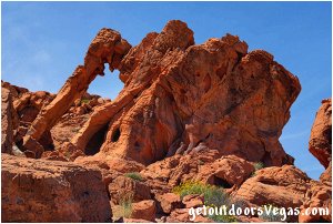
The formation known as Elephant Rock is one of the most popular attractions in the park.
This arch (one of the largest in Valley of Fire) resembles an elephant and can be visited by hiking an easy / moderate 0.3 mile trail from the parking lot (not ADA accessible).
The red sandstone hills adjacent and westerly of Elephant Rock provide abundant exploration and photographic opportunities (use trails / scrambling).
Note #1: Elephant Rock, located just off the Valley of Fire Hwy. can be seen driving west from the East Entrance Station: on your right / approaching the crest of the first hill (be aware of hikers near the road).
Note #2: Continuing east 0.6 miles from the East Entrance Station is the easterly most of Valley of Fire's two "formal" entrance signs.
Scenic Loop Road:
The Valley of Fire Scenic Loop Rd. is a 2 mile long paved / all weather gravel road near the parks West Entrance Station.
The Scenic Loop Rd. (described here counterclockwise) encircles an outstanding area of red sandstone outcroppings containing some of the parks more famous attractions.
At a point 1.8 miles east (along the Valley of Fire Hwy.) of the West Entrance Station turn left (northerly) onto the paved section of the Scenic Loop Rd.
Along the Scenic Loop Rd. (0.3 miles from the Valley of Fire Hwy.) is the entrance to the Atlatl Rock Campground.
This campground (one of two in the immediate area - no reservation system) is open year-round; has 44 campsites for tents, trailers and RVs.
Amenities include drinking water, tables (some shaded), fire ring / grates, flush toilets and showers (ADA accessible) and an RV dump Station.
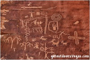
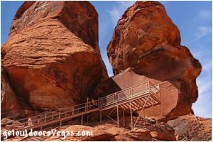
Continuing along the Scenic Loop Rd. (0.5 miles from the Valley of Fire Hwy.) is the parking area for Atlatl Rock.
Atlatl Rock itself is a large boulder atop a sandstone outcrop at the top of a metal staircase located 200 feet beyond the parking area.
Here is a well preserved (protected by metal fencing) rock art panel with numerous petroglyphs including Bighorn Sheep and the "atlatl" (throwing stick - utilized to throw arrows / spears before the invention of the bow).
For those unwilling / unable to climb the stairs there are other petroglyphs along the base of the rock outcrop to discover (follow a sandy wash, left and beyond the stairs).
Amenities include information signs, shaded picnic sites with grills and a restroom facility (ADA accessible).
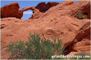
Continuing along the Scenic Loop Rd. (0.8 miles from the Valley of Fire Hwy.) is Arch Rock (on your left).
It is accepted in the scientific community that formations such as Arch Rock are formed by wind, water and the effects of salt and frost.
However, these erosive forces alone may not be the only factors in an arches development.
Recent research suggests as material is eroded from the sides / underneath a developing arch the resultant span places more force on the structure from above.
Once a "critical weight" is reached, downward force (gravity) locks the lower grains of sand more tightly together, increasing resistance to erosion.
In contrast, other parts of sandstone (bearing less weight) remain vulnerable to erosive forces.
Weaknesses in the sandstone (fractures) yield a diversity of shapes such as pillars, holes, balanced rocks and on occasion arches.
A little further down the Scenic Loop Rd. Arch Rock Campground (on your left - no reservation system) is serviced by a loop road.
This campground is more primitive than the previously noted Atlatl Rock Campground.
Surrounded by a playground of red sandstone on all sides, this campground has 29 campsites for tents and trailers.
Amenities include shaded tables, fire ring / grates, tent pads and flush toilets (ADA accessible).
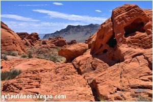
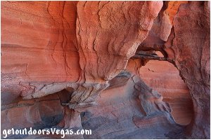
Just over 1 mile along the Scenic Loop Rd. pavement gives way to an all weather gravel road surface.
This remaining section (under 1 mile - dusty, with washboards and occasional potholes) is drivable by all vehicle types.
Here there are many small arches, holes, alcoves, nooks and crannies with a seemingly infinite number of exploration possibilities along this section, just find a safe pullout and start exploring.
The Scenic Loop Rd. exits onto the Valley of Fire Hwy. 0.9 miles east of the West Entrance Station.
Note: the Scenic Loop Rd. can be driven in both directions.
White Domes Road:
Located along the Valley of Fire Hwy. 3.7 miles east of the parks West Entrance Station the White Domes Rd. (paved - just under 6 miles in length) leads to the Visitor Center and northern sections of the park.
Along this route red sandstone formations of the valley floor transition (at higher elevations) into rainbow mixtures of red, white, yellow, pink and purple sandstone.
With grand vistas, extraordinary colors and endless exploration / photographic opportunities the White Domes Rd. should be on everyones itinerary.
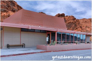
Along the White Domes Rd. (0.1 miles from the Valley of Fire Hwy.) is the entrance to the upper parking lot for the Valley of Fire Visitor Center (White Domes Rd. veers left).
The upper lot provides ADA drop-off with a couple of ADA parking stalls and a dozen regular parking stalls (no over-sized vehicles).
Continuing along the White Domes Rd. (0.2 miles from the Valley of Fire Hwy. - on your right) is access to the lower Visitor Center parking lot (oversized / overflow parking).
The Visitor Center offers exhibits and visitor services (printed maps, hiking and general information) for Valley of Fire State Park and the surrounding area; as well as snacks, books and souvenirs.
Exhibits include information on the geology, ecology, prehistory and history of the Valley of Fire.
Amenities include: restrooms, drinking water, first aid, telephone and a ranger station.
Outside the Visitor Center there is a garden area with large cacti to stroll through.
Red sandstone formations provide a backdrop for the Visitor Center, with places to explore (around and immediately adjacent to the upper parking lot).
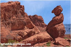
The trail to Balanced Rock (0.3 miles round trip - trailhead: upper parking lot by the ADA parking area) is an easy stroll with very little elevation gain.
Once there, walk around this beautiful formation to see that it is truly a "balancing rock".
Return by retracing your steps.
Back on the White Domes Rd. (0.4 miles from the Valley of Fire Hwy.) the road begins climbing out of the valley and at 0.6 miles enters a tight red rock canyon.
For the next 0.5 miles this canyon often seems like a "tunnel of rock".
With only a few parking opportunities (look for safe pullouts), its worth spending time exploring this diverse and beautiful canyon.
At a distance of 1.2 miles from the Valley of Fire Hwy. is the parking area for Mouse's Tank and the Petroglyph Canyon Trail (on your right).
Immediately beyond the Mouse's Tank parking area is a picnic area (on your left) with shaded tables, grills and an ADA accessible restroom facility.
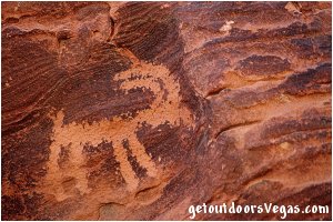
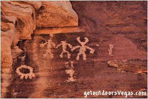
The Petroglyph Canyon Trail (about 0.75 miles round trip) is an easy hike with very little elevation gain / loss following the bottom of a sandy wash.
Along this trail there are many examples of "rock art" (on your left hiking down canyon) which were etched into desert varnish.
Desert varnish is composed of iron and manganese that leached from the rock and evaporated as a thin dark layer.
Ancient peoples used the darkened layers as canvases for their "rock art", revealing the red rock underneath.
Please admire these artifacts from afar, climbing on or even touching them causes great damage.
At trails end is Mouse's Tank, named for a renegade Southern Paiute Indian ("Little Mouse") who gave other Indians and settlers in this region great trouble and used the area as a hideout in the 1890s.
Mouse's Tank is defined as a tinaja, an American Southwest term for surface pockets carved out by sand and gravel in intermittent streams that trap and hold water during dry periods.
Tinajas have always been a valuable resource for Native Americans, settlers and wildlife in the desert Southwest region.
Return to trail-head by reversing route.
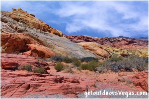
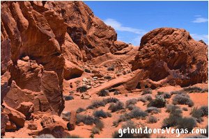
Continuing along the White Domes Rd. (1.9 miles from the Valley of Fire Hwy.) is the Rainbow Vista parking area (on your right).
Here the White Domes Rd. crosses over a low ridge revealing a vast area of multicolored sandstone formations stretching many miles northward.
The parking area has a few picnic tables (no shade) and a ADA accessible restroom.
Across the road from the parking area are panoramic views, photographic opportunities and places to explore.
Behind the parking area is the trail-head for the Rainbow Vista Trail.
This trail ventures down a sandy canyon (southeasterly - 1.5 mile round trip - approx. 130 feet of elevation change) to the Fire Canyon Overlook with beautiful views to the south and east.
Although marked with trail markers along portions of its route the Rainbow Vista Trail can be confusing with use trails heading in multiple directions.
NOTE: From this point forward parking is permitted only in designated turnouts / parking areas.
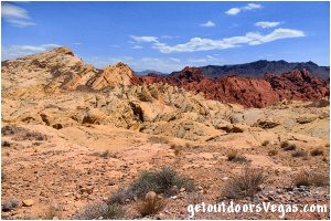
Continuing along the White Domes Rd. (just over 2 miles from the Valley of Fire Hwy.) is Fire Canyon Rd. (on your right).
This paved (0.7 mile long) road has a couple of turnouts and the Silica Dome Overlook parking area at its end.
Amenities include informational signs and an ADA accessible restroom.
The parking lot (accommodates 15 or so vehicles) is the high point of the road and has stunning views overlooking two prominent geological features, Silica Dome and Fire Canyon.
Silica Dome (as with all sandstone formations in the Valley of Fire) is composed of sand grains that are almost pure silica.
This dome, the finest example in this area of Valley of Fire is such a deposit.
The change in color from yellow / white to red at the base of the dome is due to small quantities of iron in the silica producing a rust-like stain.
This color boundary marks the upper reaches of Fire Canyon seen to the right and below Silica Dome.
Looking northeasterly from the parking lot (behind the restroom facility) one can see Moapa Valley and the community of Overton, Nv.
Note: For you Star Trek fans, the Silica Dome Overlook area is where Kirk fell to his "death" in the filming of the Generations movie.
You can visit the actual metal bridge from which Kirk fell by hiking a short (3-4 minute - mostly level) road / trail from the Clark Memorial Site on the Valley of Fire Hwy.
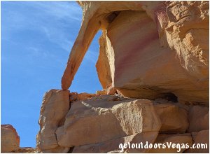
Back on the White Domes Rd. (2.8 miles from the Valley of Fire Hwy.) is Parking Area #1 (on your left - no amenities).
This parking area has sweeping views in all directions with places to explore behind (west) of the gravel lot.
Continuing along the White Domes Rd. (3.5 miles from the Valley of Fire Hwy.) is Parking Area #2 (on your left - no amenities).
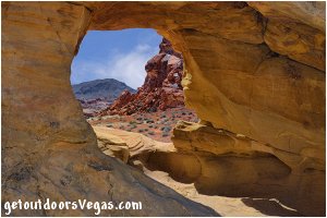
Here one can cross White Domes Rd. and follow an abandoned dirt road (blocked by concrete bollards) for about 400 feet, a small arch (see photo above) is to the right (south) and around the back side of the formation in front of you.
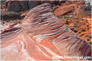
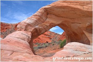
Continuing along the White Domes Rd. (4.8 miles from the Valley of Fire Hwy.) is Parking Area #3 (on your left - no amenities).
This parking area is very popular, a major attraction being the trail-head for the Fire Wave Trail (across the road - 1.5 mile round trip - approx. 175 feet of elevation change).
The Fire Wave Trail is a newer trail in Valley of Fire State Park that does not appear on some of the older park maps.
At trails end Fire Wave has a bowl shaped depression with interchanging streaks of beige and red-orange colored sandstone.
The scenery along the Fire Wave Trail is very picturesque making this adventure one of the most popular hikes in the park.
Return to trail-head by reversing route.
Other adventures include use trails (scrambling) starting from "behind" Parking Area #3 downslope into a small wash.
Following this wash there are places to explore, beautiful formations and a few colorful arches (somewhat hard to find).
Return to parking area by reversing route.
At the end of the White Domes Rd. (just under 6 miles from the Valley of Fire Hwy.) is the White Domes Parking Area.
Amenities include information signs, ADA accessible restrooms, ADA accessible shaded picnic tables with grills and ample parking.
Here there are places to explore (use trails - scrambling) all around you.
The trail-head for the White Domes Trail is located at the far end of the parking lot (1.1 mile loop - 150 foot elevation change).
This easy / moderate loop trail (initial climb up thru sand - then down a series of steps) travels thru sandstone formations with a variety of shapes and colors.
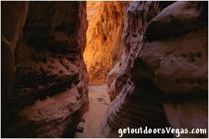
Along its "clockwise" course the trail visits an old movie set, traverses thru a short narrow slot canyon and passes by a few arches.
At trails end the hiker meets up with the White Domes Rd. and parallels the road back (600 feet) to the parking area.
Information / Tips:
Valley of Fire State Park is open from sunrise to sunset (for those camping - after hours activity is limited to campground areas).
Visitor Center hours: 8:30AM - 4:30PM daily.
Bring plenty of water / snacks, sunscreen, sunglasses, hat, sturdy shoes / hiking boots (advised) and don't forget your camera.
..........
nearby: Redstone
nearby: Rogers Spring
nearby: St. Thomas
Warning:
This adventure involves travel to a relatively remote area, please refer to the section on desert travel
for safety information. Avoid the area during extreme heat. Make sure you have a full tank of gas, a fully pressurized spare tire
and plenty of water. Remember you are responsible for
your own safety.
Directions:
From the intersection of W. Flamingo Rd. and S. Las Vegas Blvd. proceed 0.3 miles West on W. Flamingo Rd.
Turn right onto Northbound I-15 traveling just over 37 miles to exit 75 and the Valley of Fire Hwy. Head East (right) on Valley of Fire Hwy.
for 14.5 miles to the Valley of Fire West Entrance Station. Approximately 52 miles (quickest route: just over 1 hour) from central
Vegas Strip to Valley of Fire West Entrance. Return by reversing route.
Note: an alternate return route involves exiting the Valley of Fire East Entrance Station. From the Entrance Station travel East on the Valley of Fire Hwy. for 2 miles turning right (South) on NV-167 (Lake Mead National Recreation Area's Northshore Rd: requires a toll / entry fee). Continue South on Northshore Rd. for 18.8 miles to the Redstone Picnic Area (M.P. 27 - a great spot to stretch your legs). From Redstone continue South on Northshore Rd. for 26.7 miles turning right onto (NV-564 West) E. Lk. Mead Pkwy. Continue on NV-564 West for 14.5 miles transitioning onto I-215 West traveling for an additional 11 miles eventually merging Northbound onto I-15 North. Travel on I-15 North for 3.5 miles exiting at Flamingo Rd. (exit 38) bearing right (East) onto W. Flamingo Rd. Travel Eastbound on W. Flamingo Rd. for 0.3 miles to S. Las Vegas Blvd. Approximately 72 miles from Valley of Fire East Entrance to central Vegas Strip (minimum: 1 hour 30 minutes) via the Northshore Rd. Distances cited here are to / from each entrance station and do not reflect mileage accumulated within Valley of Fire State Park.
