St. Thomas Ghost Town
Lk. Mead Natl. Rec. Area
Overview:
Within Lake Mead National Recreation Area lie the remnants of St. Thomas.
Founded in 1865 by Mormon settlers, St. Thomas was located along the Muddy River in what was thought (at that time) to be within Utah (Arizona Territories).
St. Thomas became an established town of farms and businesses and thrived as a stopping point along the Arrowhead Trail (Salt Lake City to Los Angeles).
The townsite is also "noted for" being the endpoint of John Wesley Powell's first Colorado River expedition (the Powell Geographic Expedition of 1869).
Mormon settlers abandoned St. Thomas (1871) when a land survey shifted the state line of Nevada east, placing all of the St. Thomas area settlements in Nevada.
At that time Nevada officials demanded five years back taxes which the Mormon settlers refused to pay.
So after a vote, the settlers burned down their homes, abandoned their crops and moved to to Utah where many founded new towns.
Around the 1880's new settlers began to arrive at the abandoned townsite, discovering good soil for farming.
Eventually St. Thomas had constructed a school, post office, grocery stores, church, soda fountain and several garages for the "new invention" of the automobile.
At its peak the population of St. Thomas was around 500 people.
Of interest, St. Thomas never had indoor plumbing or electricity but memoirs written by former townspeople were of a happy and simple life.
In 1928, President Calvin Coolidge signed a bill authorizing the construction of Boulder (Hoover) Dam.
Upon completion the dam would create Lk. Mead and as the waters rose St. Thomas would be flooded by the lake.
The residents of St. Thomas were told that they would have to relocate and that the government would reimburse them for their properties.
The filling of Lk. Mead started in 1935 and as the waters rose St. Thomas was slowly overtaken by the lake.
The town's cemetery was eventually relocated to Overton, Nevada.
One of the town's last residents (Hugh Lord) paddled away from his home (06-11-1938) when the lakes rising waters "lapped" at his front door.
Once Lk. Mead reached its "high water mark" the historic town of St. Thomas was sixty feet below the lakes surface.
With Lk. Meads historic water level fluctuations the former townsite of St. Thomas has "arisen from the depths" several times since 1938.
In 1945, 1963 and in 2012 there were reunions of former residents / family members.
Scientists suspect Lk. Mead, due to prolonged drought and demand on the regions "meager" water resources, will never refill and the abandoned townsite of St. Thomas will never-again lie under the lakes surface.
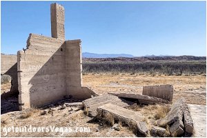
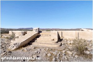
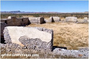
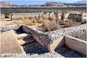
Today, St. Thomas is still exposed and visitors can roam the streets and explore the ruins of a once a thriving "wild west" town.
...trailside scenery
Information / Tips:
This adventure would make a great stopover while enjoying the Lake Mead National Recreation Area.
Bring plenty of water / snacks, hat, sunscreen, sunglasses and hiking boots (advised).
Make sure you have a full tank of gas and a fully pressurized spare tire, DON'T forget your camera.
..........
Rec. Area Hours 24hrs/day, 365days/year
2021 Entry Fee (valid 7 days): $25 vehicle & occ.
Free Entry Days (dates vary by year):
* M. L. King Jr. Day - mid January
* 1st day of Natl. Park Week - mid April
* Great Amer. Outdoors Act - EARLY AUGUST
* Natl. Park Service Birthday - LATE AUGUST
* Natl. Public Lands Day - LATE SEPTEMBER
* Veterans Day - mid November
..........
• St. Thomas Trail: not ADA accessible
• No Shade along Trail
• No Water Available
..........
nearby: Redstone
nearby: Rogers Spring
nearby: Valley of Fire
Warning:
This adventure involves travel to a relatively remote area, please refer to the section on desert travel for safety information.
Avoid the area during extreme heat.
Make sure you have a full tank of gas and a fully pressurized spare tire.
Remember you are responsible for your own safety.
Trail Directions:
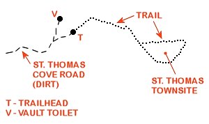
From the trailhead the St. Thomas Trail runs in a Northeasterly direction and downslope for 0.18 miles+- from the top of the trailhead ridge to the lake-bottom flats below.
Once on the flats hikers are surrounded by saltcedar trees (an invasive species) that "moved in" after the waters of Lk. Mead receded.
Note: along the former edge of the lake-bed are an overabundance of clam shells (an invasive species) left high and dry by the lakes receding waters.
Continuing, the trail in short order bends Southeasterly following the base of adjacent hills and eventually (in 0.27 miles+-) reaches the first visible ruin along the trail (Whitmore home).
Continuing for an additional 0.18 miles+- hikers encounter a "Y" intersection (see map below) and the "entrance" to the main townsite itself.
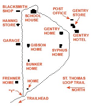
From the "Y" intersection bear left (East) into the main townsite and follow the townsite loop in a clockwise manner.
Along this route there are many structures, eg. old building foundations with a few standing wall remnants, cisterns, remnants of irrigation canals and historic debris.
The clockwise loop, 0.83 miles+- in length, eventually returns to the aforementioned "Y" intersection.
From this point return to the trailhead (0.63 miles+- distant) along the trail section previously taken.
..........
Trail Summary (as described above):
Length: 2.1 miles+- (distance out & back)
Elev. Difference: 100 feet+- (high pt. vs low pt.)
..........
Trailside Information Signs (summary):
• history of crops and farming
(Native Peoples & European)
• state line history (and controversy)
• federal government buyout of properties
• rising waters of Lk. Mead, floodwaters
• falling waters (town re-emergences)
• arrival of railroad (1912) & transportation
• home life & daily struggles
• storage & use of water by residents
• development of commerce
• mining in local mountains
• school house and education
• Gentry family store & hotel
..........
Note: named ruins (see townsite map above) and other unnamed ruins are relatively close to the trail.
Although visible from the trail the St. Thomas ruins deserve a closer look.
With a myriad of use-trails (and general wandering around) expect your adventure to exceed the distances quoted above (adjust your time accordingly).
Driving Directions:
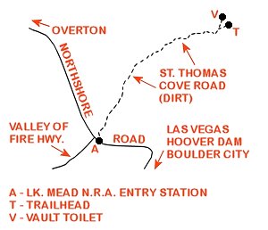
From the intersection of NV-564 (E. Lk. Mead Pkwy.) and NV-167 (Northshore Rd.) within Lk. Mead National Recreation Area head North on Northshore Rd. for 45.4 miles+- to the Lk. Mead National Recreation Area (North) Entry Station and intersection with the St. Thomas Cove Rd. (dirt - signs mark the turnoff).
Turn Right (Northeasterly) onto St. Thomas Cove Rd. traveling 3.3 miles+- to a "Y" intersection.
Bear Right traveling 0.2 miles+- to roads end and trailhead parking area.
Approx. 73 miles from the central Vegas Strip via I-15 South, I-215 East, NV-564 East (E. Lk. Mead Pkwy.), NV-167 (Northshore Rd.) and St. Thomas Cove Rd.
Trailhead amenities include informational kiosk, trailhead signs and nothing else.
Return by reversing route.
Note: from the aforementioned "Y" intersection bear left traveling 0.2 miles+- to a vault toilet (no other amenities).
..........
Note: the St. Thomas Cove Rd. is a maintained dirt road which can be accessed by most vehicles if driven carefully.
Be on the lookout for "large" rocks or washouts (due to inclement weather) or windblown sand accumulation (use your own judgment).
..........
Note: the St. Thomas Ghost Town trailhead parking area can be accessed from either Overton via NV-167 (Northshore Rd.) or thru Valley of Fire State Park (separate entry fee) via the Valley of Fire Hwy: both alternatives are not described on this webpage.
