Death Valley Natl. Park
"Single Day Itinerary"
Section Index:
...Death Valley Natl. Park - Overview
...Badwater
...Salt Creek
...Dante's View
...Options
...Directions
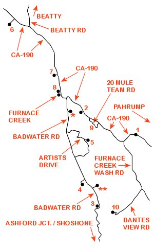
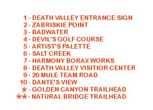
Single Day Itinerary:
Not only does Death Valley National Park cover a huge geographic area, it takes just over 2 hours (early morning departure - minimal stops) to reach from the central Las Vegas strip.
The park would take a lifetime to fully explore, requiring multiple days just to "scratch the surface".
With this in mind this web-page documents a single day itinerary for those who wish to "experience" the park while visiting the Las Vegas area.
The itinerary includes a variety of "must see" scenic attractions within Death Valley proper (easterly portion of the park), including descriptions of scenic attractions with driving, distance and time budgeting considerations.
Note: scenic attractions that are documented within the "Single Day Itinerary" are sequenced for a few specific reasons.
(1) By arriving early at Zabriskie Point then driving directly to Badwater one is able to visit these 2 attractions with fewer visitors.
(2) Early to mid-morning light is better for viewing / photographing these 2 attractions.
(3) Temperatures are lower making your walks to the Zabriskie Point Overlook and onto the Badwater Salt-Flats more enjoyable.
(4) Driving distances (e.g. - the one way "loop" road to Artists Palette) are minimized.
(5) Takes advantage of time constraints (total trip, time available for each attraction).
For a .PDF download of the "Single Day Itinerary" click: here
Death Valley Natl. Park - Overview:
Death Valley National Park was initially proclaimed a national monument on February 11, 1933 by President Herbert Hoover.
This proclamation set aside almost two million acres of southeastern California and small parts of Nevada.
The Civilian Conservation Corps (CCC) developed initial infrastructure during the Great Depression and into the early 1940s.
During this early period the CCC built over 70 buildings, barracks, water and telephone lines, 500 miles of roads and other improvements.
Trails were built to points of scenic interest with construction of campgrounds, picnic facilities and restrooms for visitor use.
In 1984 Death Valley National Monument was designated a biosphere reserve.
Ten years later, October 31, 1994 the monument was expanded by 1.3 million acres and re-designated as a national park via congressional passage of the California Desert Protection Act.
This designation elevated Death Valley National Park to the status of the largest national park in the contiguous United States.
On March 12, 2019 the John D. Dingell, Jr. Conservation, Management and Recreation Act added just over 35,000 acres to the park.
Of Death Valley's 3.4 million acres an astounding 91% is protected as officially designated wilderness.
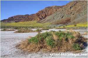
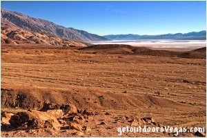
Within the park are two major valleys, Death Valley and Panamint Valley. Both valleys formed within the last few million years and are bounded by north-south trending mountain ranges. Death Valley proper (the subject of this web-page) exhibits uplifting of the surrounding mountains and subsidence of the valley floor (geologic faults). The uplifting of these mountains is so fast that alluvial fans (deposits at the mouth of canyons) are relatively small and steep. This fast uplifting along with the extremely arid environment prohibit classic V-shape erosion of the broad, flat and subsiding valley floor. As a consequence Death Valley's Badwater Basin, the lowest elevation in the United States and second-lowest depression in the Western Hemisphere, sits 282 feet below sea level (at its lowest point). The highest point in the park Telescope Peak (11,049 feet above sea level) is visible from and approximately 15 miles west-southwest of Badwater Basin. Telescope Peak is notable for having one of the greatest vertical rises above local terrain (Badwater Basin) of any mountain in the contiguous United States.
Death Valley is the hottest and driest place in North America due to its low elevation and geographic location.
The valley so frequently records the hottest daily high in the U.S. that many tabulations omit Death Valley from their reporting as a matter of course.
Daily summer temperatures greater than 120°F are common with overnight lows averaging 88°F.
The high at Furnace Creek (near the Visitor Center) on July 10, 1913 was recorded at 134°F and is to this day is the highest ambient air temperature ever recorded at the surface of the earth.
Winters are mild with average highs around 70°F and nightly temperatures dropping below freezing.
Due to extreme temperatures the recommended time of year to visit Death Valley National Park is mid-fall to mid-spring - AVOID DURING SUMMER.
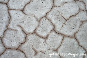
The Death Valley region is geographically removed from the Pacific Ocean by five mountain ranges, of which the Sierra Nevada, Argus Range and the Panamint Range (Telescope Peak) are most significant.
Air masses from the Pacific lose moisture as they are forced up over these ranges, in what climatologist call a rainshadow effect.
This rainshadow effect makes the Death Valley area North America's driest spot.
Average precipitation for Death Valley National Park (Furnace Creek Station) is 2.3 inches per year with Dec-Mar being the wettest and May-July being the driest months.
Badwater Basin receives only 1.5 inches of precipitation annually (some years fail to register any measurable rainfall).
When rain arrives it often does so in intense storms causing flash floods which can "remodel" the landscape (including park infrastructure).
BE AWARE of weather conditions in your exploration of the park (extreme temperatures, flash flood potential, lighting, strong winds).
Entrance Sign:
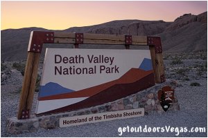
Even though this stop is not addressed within the "Single Day Itinerary" for Death Valley National Park it is mentioned here.
This 5 minute diversion affords a quick stop and photo op for interested individuals.
The only amenity being a large gravel parking area (no information boards or comfort facilities are provided).
Note: continuing into the park an unmanned Entrance Fee Pay Station (not shown on the itinerary map) is just under 2 miles down the road.
The turnout is paved with ADA compliant restrooms, a phone and the pay station itself (there may be a few informational signs also).
Zabriskie Point:
This is the first "official" stop on the "Single Day Itinerary" for Death Valley National Park.
Zabriskie Point is one of the most famous viewpoints in the park, overlooking a spectacular landscape of fantastically eroded golden badlands which feature impressive canyons and gulches.
The hard, sun-baked slopes around Zabriskie Point support little to no vegetation allowing rare and often torrential rainstorms to reshape the landscape.
Here there are views of Manly Beacon, Red Cathedral, Telescope Peak and a glimpse of the valley floor over 700 feet below you.
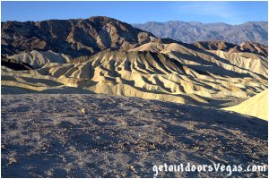
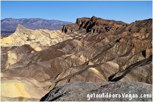
Zabriskie Point was named after Christian B. Zabriskie (10/16/1864 - 2/8/1936) who for 36 years served as the vice-president and general manager of the Pacific Coast Borax Company in the early 20th century. This company established, aggressively developed and marketed the now famous "20 Mule Team Borax" trademark in order to promote the sale of its product. The "mining" of borax in the Death Valley area occurred long before the establishment of Death Valley National Monument (1933).
The Zabriskie Point parking lot is a large paved lot with ADA compliant restrooms, trash bin and unmanned Fee Pay Station. To reach the viewpoint itself one must take a 20 foot wide paved pathway from the parking lot, gaining then losing 60 feet+- in elevation over a round-trip distance of just under 0.4 miles. Along this pathway there are a couple of benches for those needing a quick breather. The pathway winds up ending at a large cul-de-sac like viewing area with informational signs and 360° views. For most people Zabriskie Point is easily accessible (baby strollers are common), however use your own discretion for those with walking and or wheelchair considerations.
Badwater:
Continuing from Zabriskie Point drive West on CA-190 for 3.5 miles to the intersection of Badwater Road.
At this intersection one may notice a sign denoting that you have reached Sea Level.
Badwater Road is one of the main roads through Death Valley providing access to many of the parks most popular attractions.
Along this easy paved road is Badwater itself and access to a couple of other itinerary attractions (Devil's Golf Course and Artists Palette).
In keeping with the "Single Day Itinerary" turn left (South) onto Badwater Road traveling 16.5 miles to the large parking area for Badwater "Basin".
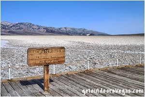
Badwater "Basin", the lowest point in North America (282' below sea level) is a surreal landscape of vast salt-flats. Next to the parking area a small spring-fed pool of water collects in a depression or "sink". The pool accumulates salts from the surrounding basin resulting in undrinkable "bad water" which gave the area its name. This pool has animal and plant life including pickleweed, aquatic insects and the Badwater Snail (endemic / restricted to Badwater Basin). This "bad water" sink is not the lowest point of the basin. The lowest point (only slightly lower than the pool) is several miles westerly and varies in location (dependent on rainfall / evaporation patterns). Of interest: Mt. Whitney (elev. 14,505') the highest point in the contiguous 48 states is only 85 miles to the northwest.
Badwater "Basin" proper is approximately 7.5 miles in length (North-South) and around 5 miles wide (East-West) at its widest point, being a portion of an ancient lake-bed.
Any water (rainfall / snow-melt / springs) entering the basin is "trapped" and therefore unable to flow out of the valley.
Periodic rainstorms flood the salt-flats, covering them with a thin sheet of water.
When flooded, salt is dissolved into the water and redeposited as clean white salt crystals when the newly formed lake(s) evaporate.
These "ephemeral lakes" do not last long due to low rainfall (avg. 1.5" per year) and excessive evaporation rates.
This leaves behind salt deposits that cover the basin "like a salty dusting of snow".
As these salt crystals expand they push the crust into rough chaotic forms, "sketching" strange patterns on the surface of the salt-flat.
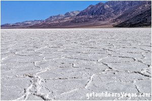
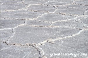
The hike onto the Badwater Salt-Flats is a unique experience, being entirely smooth and level. From the parking lot there are ramps on either side of the large parking lot and a central stairway leading to a wooden boardwalk. The boardwalk provides access onto the salt-flats, also serving as a viewing platform overlooking the spring-fed pool of water mentioned above. There are informational signs and a wooden sign (photo op) denoting your "arrival" at Badwater Basin. The boardwalk extends just shy of 200 feet onto the salt-flats followed by a well defined use-trail trampled smooth by countless visitors before you. Across the valley lies the Panamint Range and Telescope Peak (11,049 feet above sea level). Looking back towards the parking lot and to the cliffs beyond is a sign denoting sea level (well above Badwater Road). Following the use-trail for 10-15 minutes or so gets you past most of the other visitors and into pristine areas of white salt displaying some amazing pressure ridges, cracks in the salt and stunning views of the mountains around the valley. This is a great place to wander with the Badwater parking lot always visible to guide you upon your return.
The Badwater parking lot is a large paved area with ample parking for cars (if really busy parking may be a problem), large stalls for over-sized vehicles and handicap parking. Amenities include informational signs, ADA compliant restrooms, a small trash bin and unmanned Fee Pay Station. Of interest: atop the restrooms and also across Badwater Road are small weather stations. As mentioned previously there are ramps (paved) on either side of the large parking area for ADA access to the wooden boardwalk. The boardwalk itself permits wheelchair access although wheelchair users may need help navigating the wooden slats. ADA access to the salt-flats is possible, however use your own discretion for those with walking and or wheelchair considerations.
Devil's Golf Course:
After visiting Badwater reverse course heading North on Badwater Road for 5.6 miles to the intersection of a dirt road (Salt Pool Road).
Signs mark the turnoff.
Turn left (West) onto Salt Pool Road and travel 1.2 miles to roads end and the Devil's Golf Course.
This dirt road is a little bumpy but well graded and suitable for any car, just drive slow (road is subject to closure in wet weather).
The Devil's Golf Course parking area has an informational sign with no other amenities.
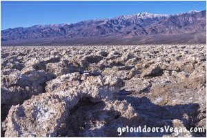
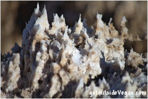
Devil's Golf Course is a vast incredibly serrated salt-flat formed by the deposition of minerals left behind by an ancient evaporated lake. Over the course of thousands of years the features of Devil's Golf Course have been sculpted by weathering processes into fantastic shapes. While the salt-flat occasionally floods during extreme rain events, flood waters are unable (usually) to smooth the surface due to the salt-flats elevation (being a few feet above typical flood level). Salt expands from underlying muds and grows uninhibited into fantastic, intricately detailed pinnacles. These pinnacles "grow" very slowly, perhaps as little as one inch every thirty years or so with wind and rain continuously sculpting the salty spires we see today. Seen from afar Devil's Golf Course may seem a little underwhelming, but seen up-close one can only marvel at the intricate detail in front of you. BE AWARE: THESE FEATURES ARE RAZOR SHARP so be mindful of yourself (and your kids) as a misstep and or fall could be very damaging. Of interest: shortly after the comment "only the devil could play golf on its surface" appeared in the 1934 National Park Service guide book to Death Valley Natl. Monument - Devil's Golf Course was given it's name.
Artists Palette:
After visiting Devil's Golf Course return along Salt Pool Road to Badwater Road.
Turn left (North) onto Badwater Road traveling 2.4 miles to the intersection with Artists Drive (signs mark the turnoff).
NOTE: VEHICLES OVER 25 FEET IN LENGTH ARE PROHIBITED on Artists Drive.
Turn right (East) onto the one-way Artists Drive loop traveling 4.3 miles to the turnoff for Artists Palette (signs mark the turnoff).
Turn right onto the two-way Artists Palette access road traveling 0.2 miles to roads end.
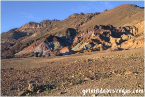
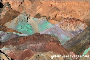
Artists Drive is one of the unique things to do in Death Valley Natl. Park. The drive passes through canyons and past mountains, many of which are very colorful. The fully paved road has many curves, lots of dips (an enjoyable experience for your author) and fantastic views down into Death Valley. There are pullouts for photo ops and short walks to viewpoints (we often eat lunch aside the road - watch your kids).
Upon reaching Artists Palette the colors can be amazing (best in late afternoon or under cloudy conditions). This multicolored hillside is where volcanic ash and minerals were deposited millions of years ago. Time, rain and heat have transformed the minerals (a result of oxidation) into different color tones, giving the area a "palette-like" appearance. Colors displayed here are predominantly purples, blues and greens sitting within a red-yellow canyon of surrounding terrain. It is possible to walk (use-trails) among these features, they are only a few hundred feet (not ADA accessible) from the parking area and well-worth the effort if time allows. The parking area is relatively small but adequate. Amenities include a single stall ADA compliant restroom facility and information sign.
Salt Creek:
After visiting Artists Palette return along the Artists Palette access road to Artists Drive.
Turn right onto the Artists Drive loop (remember this is a one-way road) traveling thru colorful canyons and many curves for 4.5 miles to the intersection with Badwater Road.
Turn right (North) onto Badwater Road traveling 4.8 miles to the intersection with CA-190.
Turn left (Westbound) onto CA-190 traveling past Furnace Creek, the Visitor Center and Harmony Borax Works areas for a total distance of 11.9 miles to Beatty Junction (turnoff for Daylight Pass Road).
Continue for an additional 2.4 miles on Westbound CA-190 to the turnoff to Salt Creek (signs mark the turnoff).
Turn left onto the graded dirt road (suitable for any car - just drive slow) traveling 1.2 miles to roads end and the Salt Creek parking area.
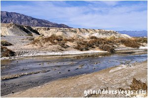
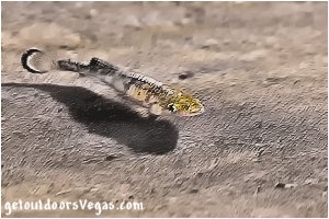
Salt Creek is a remnant of an ancient lake which covered this area. As the climate became more arid the lake dried up, leaving various saltwater springs and waterholes scattered throughout Death Valley. These changing and more restrictive conditions isolated the pupfish of Salt Creek who evolved to survive in their new environment. In addition to the saltwater environment, Salt Creek Pupfish have adapted to water temperatures ranging from near-freezing to almost 108°F. The Salt Creek Pupfish grows to approximately 2 inches in length, is endangered and lives nowhere else. The best time to see the pupfish is late winter / early spring (photo above taken 4/20/18).
The Salt Creek Interpretive Trail is a short level half-mile loop on a boardwalk running parallel to Salt Creek. This spring-fed creek supports a salt-marsh in the middle of one of the driest places on earth. The marsh consists of mainly pickleweed and salt grass, two plants that have adapted well to this harsh and unique environment. The area supports birds, lizards and insects in addition to the Salt Creek Pupfish. Early on in the trail, the boardwalk skirts the side of Salt Creek. If you look closely you may see some pupfish darting through the water here, if not don’t worry, more might be seen further upstream (dependent on the time of your visit). As mentioned above late winter / early spring is the best time for possible sightings of this amazing little fish. By late Spring / early Summer much of the water of Salt Creek will have dried up. Therefore, depending on the time of year the creek will have a surprising flow or might be a dry wash. Eventually, the boardwalk splits and begins the "actual" loop (following either section returns you to this point). Both routes take you to a short bridge (with handrails) which acts as a viewing platform over the spring-fed pools of upper Salt Creek (only section that has water year-round). This tiny chain of pools is the only place where the pupfish eggs can survive / hatch into the next generation. Gazing into the water here (especially during the late winter / early spring) you’re likely to see pupfish along the creek-bed. Continuing on, the boardwalk loops back to where it originally split and returns to the parking area. Note: The boardwalk itself permits ADA access, those with walking and or wheelchair considerations may need help navigating the gravel parking area and wooden slats (windblown sand can accumulate on / cover portions of the boardwalk - use your own discretion).
The Salt Creek parking area is large and can accommodate any vehicle (park nearest to the boardwalk for ADA access). Interpretative signs are near the boardwalk entrance and along the boardwalk loop. There are benches along the loop trail for those needing a rest / quick breather. A vault toilet is available (not ADA accessible).
Harmony Borax Works:
After visiting Salt Creek return along the gravel Salt Creek access road to CA-190.
Turn right (Eastbound) onto CA-190 (traveling past Beatty Junction) for a total distance of 11.7 miles to the turnoff for Harmony Borax Works (Borax Mill Road - signs mark the turnoff).
Turn right onto Borax Mill Road traveling 0.2 miles to the end of pavement and the parking area for Harmony Borax Works (on your left).
The paved parking area has ample parking with parking stalls for over-sized vehicles (no other amenities).
ADA parking is provided next to the trail-head.
Note: for individuals unable to utilize the trail the "exhibit" is visible from the parking lot.
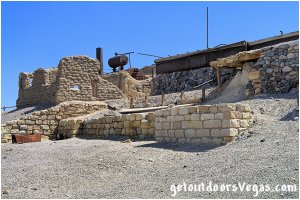
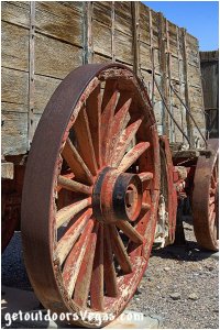
After Borax was discovered near Furnace Creek by Aaron and Rosie Winters in 1881, William T. Coleman and Francis M. Smith obtained claims to the deposits. Coleman subsequently built the "Harmony Plant" which began processing Borate ore in late 1883 or early 1884. When in full operation the Harmony Borax Works employed a workforce of forty men who produced three tons of Borax daily. From the heart of Death Valley getting the finished product to market was a difficult task, therefore an efficient method of transport had to be devised. The Harmony operation gained fame by utilizing large mule teams / double wagons to haul Borax along the overland route to the nearest railroad which was in Mojave, California. The romantic image of the “20 mule team” persists to this day and has become the symbol of the Borax industry in this country. Other hardships were present. During summer months air temperatures were so hot that "processing water" would not cool enough to permit suspended Borax to crystallize, forcing Coleman to move his work force to the Amargosa Borax Plant near present day Tecopa, California. After five years of production the "Harmony Plant" ceased operations when Coleman’s financial empire collapsed. Acquired by Francis M. Smith, the "works" never resumed boiling of Borate ore with unprocessed ore eventually becoming part of the Borax reserves of the Pacific Coast Borax Company and it successors. On December 31, 1974 the "Harmony Plant" site was placed on the National Register of Historic Places.
The Harmony Borax Works Interpretive Trail passes thru an outdoor museum dedicated to the history of the "Harmony Plant" and its operations.
This short loop trail is a combination of dilapidated pavement and gravel, being approximately 0.4 miles in length with a 25 foot+- elevation gain / loss.
On display is a preserved example of the famous "20 mule team" wagons, the crumbling half-standing walls of the "Harmony Plant" itself and other odds and ends.
Along the trail there are several sighs with information relating to the "Harmony Plant" and old town-site, the "20 mule team" and the discovery of what miners in the late 1800's referred to as "white gold".
The interpretive trail should be considered as having a moderate grade.
Those with walking and or wheelchair considerations may need assistance (use your own discretion).
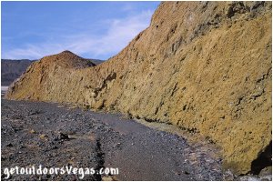
Note: prior to departing for the Furnace Creek Visitor Center a short detour via Mustard Canyon Drive is available (not shown on the itinerary map). Mustard Canyon Drive is a 1.3 mile one-way dirt road that starts at the Harmony Borax Works parking area (turn left from parking lot). The drive heads North then East eventually looping back to CA-190 at a point about 0.75 miles north of Borax Mill Road. This graded road is relatively smooth (drive slowly) with limited pullouts and easily passable in any vehicle (over-sized vehicles not recommended). This 10-15 minute detour passes thru low-lying yellowish mustard-colored hills colored by salt and oxidized minerals - seemingly absent of plant life.
Visitor Center:
After visiting Harmony Borax Works return along Borax Mill Road to CA-190.
Turn right (Eastbound) on CA-190 traveling 1.4 miles to Airport Road and the turnoff for the Death Valley Visitor Center at Furnace Creek (signs mark the turnoff).
Turn right then take an "immediate" right into the Visitor Center parking lot.
The Visitor Center lot is laid out as a counterclockwise loop (follow directional arrows), fully paved with adequate parking spaces (some provide shaded cover), over-sized vehicle spaces, ADA parking and trash receptacles near the parking lot exit.
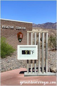
The Death Valley Visitor Center at Furnace Creek is the main visitor information source for the park.
Originally built in 1959, the Visitor Center was remodeled / re-opened in November 2012.
The 20,500 square foot building holds an array of exhibits and a 20 minute film "Seeing Death Valley" narrated by Donald Sutherland.
There is a nice museum section covering the geology, history and wildlife of the park with a full scale model (map) of the Death Valley area.
This very helpful and well-thought out Visitor Center has a fully staffed information desk with details on all aspects of the park and its operation (fees / passes are available for purchase).
Staff and volunteers willingly help to answer visitor questions, being very informative and helpful.
Amenities include, ADA assisted listening and audio description devices for the park film and exhibits, gift shop (nice selection of souvenirs), ADA accessible restrooms, water fountains, water bottle filling station and of course air-conditioning.
Food is not available; however drinks / snacks can be purchased in the gift shop.
An "exhibit" (just outside the entrance) displays the current temperature, a great photo op (image above taken 4/20/18).
The Visitor Center is open everyday from 8:00am to 5:00pm.
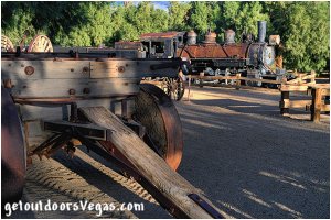
Note: prior to departing for 20 Mule Team Road an additional stop is available. On CA-190 (Eastbound), about 0.25 miles from the Visitor Center is the "village" of Furnace Creek, one of the park's major tourist facilities. At 190 feet below sea level Furnace Creek holds the record for the highest recorded air temperature on Earth at 134°F (07/10/1913). Amenities include a resort, golf course, gas station (between the Visitor Center and Furnace Creek - very expensive), ice cream / coffee bar, restaurant, post office and gift shop / general store. Also on site is the Borax Museum. The museum consists of a main building (with exhibits) and outdoor exhibit area. The building (oldest in Death Valley), constructed in 1883 by F.M. "Borax" Smith (founder of the Pacific Coast Borax Co.), stood originally in 20 Mule Team Canyon where it served as an office, bunk house and ore-checking station. Outdoor exhibits include pioneer-era mining and transportation equipment including "20 mule team" wagons. The museum highlights Death Valley's historic connection to the Native American people of the area, prospectors and the mining of Borax. Pamphlets are available helping to make sense of it all. The Borax Museum is open 10:00am to 5:00pm Tuesday-Saturday (hours / days may vary).
20 Mule Team Road:
After visiting the Furnace Creek Visitor Center head Eastbound on CA-190 for just under 6 miles (passing thru the intersection with Badwater Road) to the signed turnoff for 20 Mule Team Canyon.
Turn right onto the one-way graded dirt road (20 Mule Team Road) entering into 20 Mule Team Canyon.
This 2.7 mile long drive heads along a fairly wide wash for the first 1.7 miles then winds up and down over rolling mud-stone hills eventually rejoining CA-190 at roads end.
When stopping for photos or general interest, be aware that portions of the road are one-lane with blind curves and few turnouts (respect other drivers behind you - watch your kids).
The road is maintained and suitable for all vehicles except large RVs or similar.
When wet (rare) the road becomes impassable (check with park staff).
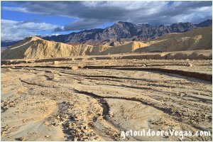
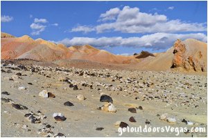
20 Mule Team Canyon is a canyon that can be experienced right from the driver's seat. The spectacularly colorful landscape seen from Zabriskie Point extends several miles Southeasterly (bordering CA-190) and may be viewed close-up via 20 Mule Team Road. For part of the 2.7 mile distance the eroded badlands on either side have greatly contrasting colors: black or dark brown Westerly - cream, yellow and white Easterly. There are narrow twisting ravines, patches of mineralized rocks and amazing views across the scenic badlands. Evidence of past mining activity is plentiful, passengers can play a game of "who-can-spot" the most Borax shafts along the way. Mines in this region were established in the early 1900s by prospectors looking for Borax and Gypsum, both quite plentiful. It's interesting to note: the famed “20 mule team” wagons after which the canyon is named did not actually pass through 20 Mule Team Canyon. This picturesque and enjoyable drive with beautiful terrain is an easy side trip for those driving to Dante’s View.
Dante's View:
NOTE: BUSES, RVs AND VEHICLE COMBINATIONS OVER 25 FEET IN LENGTH ARE PROHIBITED ON DANTE'S VIEW ROAD (for trailers see below).
Upon exiting 20 Mule Team Canyon turn right (Eastbound) onto CA-190 traveling 4.4 miles to the signed turnoff for Dante's View (Furnace Creek Wash Road).
Turn right (Southerly) traveling 7.5 miles along Furnace Creek Wash Road to its intersection with Dante's View Road.
A parking area (to your right) provides for trailer drop-off (no other amenities) prior to your ascent up the most challenging part of the road.
Continue straight onto the paved Dante's View Road (Furnace Creek Wash Road bears left - transitions to dirt) traveling upslope thru winding terrain for 5.1 miles to a parking area with an ADA accessible vault toilet (last chance) and no other amenities.
Travel an additional 0.5 miles on Dante's View Road, thru very steep and tight uphill curves, to the Dante's View parking area and roads end.
The Dante's View parking lot has adequate parking (ADA parking is available) with a newly upgraded viewing platform (Spring 2018).
The viewing platform is supported by a retaining wall which stabilizes the eroding hillside.
Atop the platform a wall with protective railing encompasses the area allowing visitors to enjoy the surrounding view "right from the edge".
Amenities include ADA access, benches, informational signs and a bronze tactile (3D) map of the surrounding landscape.
Trails (not ADA accessible) head out in both directions from the parking lot, the trail to the left (South) being the most popular and easiest to explore for additional views (watch your kids).
Along this trail (away from the parking lot) one can experience "deafening" silence on calm days.
Note: due to elevation and the potential for very strong winds, air temperatures at Dante's View may be significantly colder than in the valley (be prepared).
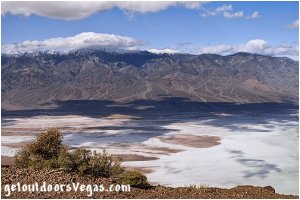
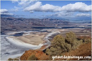
Dante's View, at 5,476 feet above sea level (over 1 mile above the valley floor), is one of the most popular sites in Death Valley Natl. Park and a great spot for a sweeping panoramic view of the southern Death Valley basin. The view is considered to be one of the great photographic spots in the park. Below the viewpoint lies a number of the parks attractions including the Badwater salt-flats, Devils Golf Course and Badwater Road as it travels north towards Furnace Creek and the Visitor Center. Across the valley is the 11,049 foot high Telescope Peak (might be snow covered) towering 11,331 feet above the valley floor, 5,573 feet above Dante's View. Note: on very clear days the highest point (Mt. Whitney @ 14,505') and the lowest point (Badwater Basin @ -282') in the contiguous United States can be simultaneously seen from Dante's View. With its spectacular scenery and grand vistas, Dante's View provides a great overview of your visit to Death Valley Natl. Park.
Options:
In addition to Mustard Canyon Drive and the "village" of Furnace Creek (mentioned above), additional options for consideration are offered here.
Both are along Badwater Road (see itinerary map) and are not addressed in the "Single Day Itinerary".
For those who wish to visit either or both of these sites remember to appropriately alter your "personalized" itinerary.
1. The Golden Canyon Trailhead is located just off Badwater Road approximately 2 miles South of CA-190 (signs mark the turnoff).
Visible from Badwater Road the medium sized paved parking lot accommodates a dozen cars, parking for over-sized vehicles and 2 ADA accessible parking stalls.
Amenities include a vault toilet (ADA accessible), informational sign, trail guide "kiosk" and trash receptacle.
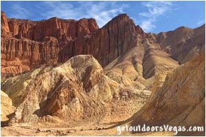
Golden Canyon and its surrounding terrain is a labyrinth landscape of golden colored hills and narrow winding canyons.
Hiking options (not ADA accessible) range from an easy 10-15 minute stroll to strenuous adventures (hike to Zabriskie Point - approx. 6.25 mile "loop" with 700+ foot elevation gain).
One of the most popular routes is the hike from Golden Canyon Trailhead to Red Cathedral (see photo above).
This hike (3 mile "loop") is considered moderate (minor rock scrambling) and takes up to 2 hours to complete.
Realistically, to adhere to the Single Day Itinerary a quick stop and short stroll (if time allows) is the recommended option for this area.
2. The Natural Bridge Trailhead is accessed from the parking area at the East end of Natural Bridge Road (all weather gravel).
Along Badwater Road 13 miles South of CA-190 (3.5 miles North of Badwater) is the turnoff to Natural Bridge Road (signs mark the turnoff).
Head East along Natural Bridge Road for 1.5 miles to roads end and a large gravel parking area.
Amenities include a vault toilet (ADA accessible with assistance) and information sign.
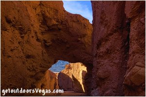
The 1 mile "loop" hike to Natural Bridge is easy to navigate but very rocky (not ADA accessible) and can be completed in less than an hour.
The route follows a narrow canyon wash to Death Valley's largest rock span.
If so inclined one can continue beyond the "bridge" to a dry waterfall at trails end (adds an additional mile to the hike).
On return, once outside of the canyon are great views of the salt-flats near Badwater and mountains across the valley.
This "stop" is a highly recommended option and deserves consideration as an alternative to itinerary attractions which may not interest certain individuals.
Information / Tips:
To adhere to the Single Day Itinerary plan on premade breakfast, lunch and snacks that can be eaten on the road.
Your experience may differ based upon your driving habits, the number of people in your party, if you have kids with you and personal preferences.
Driving distances / time, arrival / departure times and time allotted for each attraction are utilized here only as a guide (familiarize yourself with your route and itinerary).
Don't forget to bring plenty of water, sunscreen, a hat, sunglasses, good walking shoes and most importantly a camera.
Park Hours: 24hrs/day, 365days/year
Visitor Center Hours: 8am-5pm every day
Cell Coverage: none to minimal
Pets: not recommended
..........
2020 Entry Fee (valid 7 days): $30 vehicle & occ.
Free Entry Days (dates vary by year):
* M. L. King Jr. Day - mid January
* 1st day of Natl. Park Week - mid April
* Natl. Park Service Birthday - LATE AUGUST
* Natl. Public Lands Day - LATE SEPTEMBER
* Veterans Day - mid November
..........
nearby: Ash Meadows Natl. Wildlife Refuge
Warning:
This adventure involves travel to a relatively remote area, please refer to the section on desert travel for safety information.
Make sure you have a full tank of gas, a fully pressurized spare tire and plenty of water.
AVOID THE AREA DURING EXTREME HEAT.
Remember you are responsible for your own safety.
Directions (Vegas to Zabriskie Point):
From the I-15 (Las Vegas Fwy) interchange with W. Flamingo Rd. proceed South on I-15 for 4.7 miles utilizing the right 2 lanes and merge onto Westbound NV-160 (Blue Diamond Rd. - Exit #33).
Continue West on NV-160 for just over 52 miles into the City of Pahrump and the intersection of NV-160 and NV-372.
NOTE: WHILE IN PAHRUMP BE SURE TO FILL / TOP OFF YOUR TANK.
There are no stations between Pahrump and Death Valley Natl. Park.
Fuel is available in the park (Furnace Creek) with other stations miles apart, all very expensive.
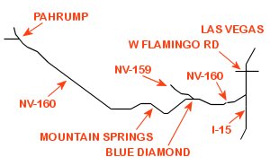
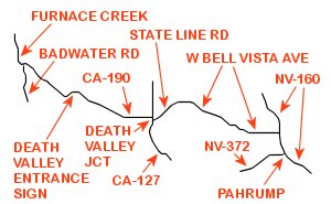
From the previously mentioned intersection of NV-160 and NV-372, continue on NV-160 for just over 4 miles turning left onto West Bell Vista Ave.
Proceed Westerly on West Bell Vista Ave. for just over 22 miles to the Nevada / California border where the highway renames to State Line Rd.
In an additional 3.5 miles State Line Rd. ends at CA-127 (Death Valley Jct).
Turn right (North) onto CA-127, proceed 0.2 miles and turn left (West) on CA-190.
Continue West on CA-190 for 16.4 miles to the Death Valley Entrance Sign for a quick photo op.
Continuing 1.4 miles West on CA-190 is the Death Valley Entrance Fee Pay Station.
From the pay station continue West on CA-190 a distance of 7.5 miles to the parking area for Zabriskie Point (being the second point to visit on the Death Valley itinerary map).
..........
Directions (Dante's View to Vegas):
After visiting Dante's View backtrack along Dante's View Road and Furnace Creek Wash Road to CA-190.
Turn right (Eastbound) onto CA-190 reversing your earlier route to Death Valley Natl. Park - Dante's View to Vegas 119 miles, approx. 2hrs 24min.
