Swiss Cheese Outcropping
Crowell Mine
The "Swiss Cheese Outcropping" (perhaps locally known as the "Cheese Rocks") lies easterly of Beatty, Nevada.
Access (described below) is via a series of graded dirt roads (high clearance vehicle recommended) which originate at the mouth of Fluorspar Canyon located a little over 1 mile south of Beatty on US-95.
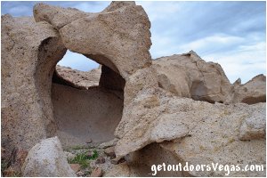
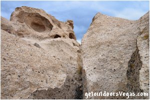
Approximately 3 1/2 acres in size, these "Cheese Rocks" are a weirdly eroded limestone formation filled with holes, caves, crevices, windows and faces.
"Kids" of all ages will enjoy this huge rock playground, exploration seems limitless and photographic opportunities are all around you.
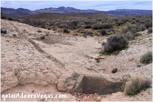
An interesting man-made feature located along the southerly margin of the formation (approximate location N36.91096 W116.65499) is a cistern.
This cistern is an excavated underground reservoir for collecting rainwater.
One can look through the collection point (covered by a screen) into the excavated cavity below.
Also of note is a "carved" ditch running along the formation surface which diverts surface water toward and into the reservoir (usually dry).
Crowell Mine:
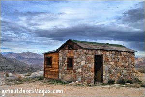
The "Fluorspar Cabin" and surrounding artifacts are relics of a former fluorspar mine.
Over the years this mine had many names, originally the Daisy Fluorspar Mine, later the Crowell Mine (after the owners) and even the Daisy Gold Mine (perhaps locally known as the Daisy Mine).
Referred to as the Crowell Mine in this discussion (as identified on recent USGS quadrangle maps), one may notice the name Fluorspar Mine above the cabin door.
Production began around 1919 and the area was actively mined into the late 80's.
Fluorite (commercially known as fluorspar) was actively mined during this period along with small amounts of uranium, mercury and arsenic.
The main shaft (immediately adjacent to the cabin) is 600 feet deep and framed with 10" square beams.
Today this shaft is covered with concrete slabs to protect curious visitors.
The surrounding area shows evidence of past activity, is hazardous and should be admired from a distance.
As with all historic sites (especially mining sites) caution should be taken while in the area.
Do not enter any open shafts, be aware of debris, watch for ground settlement and keep and eye on your kids / pets.
Please respect these historic areas, do not collect souvenirs.
Tips:
Keep an eye out for wildlife: there are Bighorn Sheep, burro and jackrabbits around (watch for snakes).
Remember water, snacks, sunscreen, your camera and binoculars.
Make sure you have a full tank of gas and a fully pressurized spare tire.
Consider road hazards / conditions during inclement weather.
This adventure would be a great side-trip while in the Beatty (Rhyolite) area.
Warning:
This adventure involves travel to a relatively remote area, please refer to the section on desert travel for safety information.
It is highly recommended to utilize a mapping program (with aerial image support) and the waypoint (WP) coordinates listed below to map your route.
This process enables the visitor to visualize the route (Fluorspar Canyon portion) prior to travel and provides a printed visual reference while on your adventure.
Remember you are responsible for your own safety.
Directions:
From the intersection of US-95 and NV-374 in downtown Beatty head South on US-95 for 1.3 miles+- to WP1.
Turn left (Easterly) up Fluorspar Canyon on graded dirt road traveling 3.3 miles+- to a "Y" intersection and WP2.
From WP2 you may consider continuing straight on a dirt road (passable - not maintained) for 0.25 miles+- to the site of the historic Crowell Mine.
Continuing toward the Swiss Cheese Outcropping bear left (Easterly) at WP2 on graded dirt road for approx. 0.5 miles to a "T" intersection and WP3.
Turn right (Southerly) and continue on graded dirt road for 0.8 miles+- to a "Y" intersection and WP4.
Bear left (Northeasterly) and continue on graded dirt road for a distance of 2.3 miles+- to WP5.
The Swiss Cheese Outcropping is visible (approximately 500') to your left and accessible via usage roads into the formation.
Return by reversing route.
Approximately 120 miles from central Vegas Strip via I-15 (North) and US-95 (North) to Beatty, Nv.
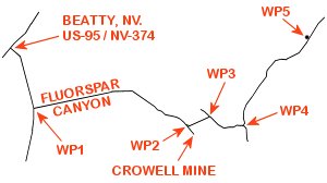
WP1: N36.89122 W116.75126
enter Fluorspar Canyon
WP2: N36.88624 W116.69674
"Y" intersection
WP3: N36.88883 W116.68847
"T" intersection
WP4: N36.88587 W116.67570
"Y" intersection
WP5: N36.91110 W116.65321
Cheese Rocks (to left)
Note:
See desert travel for GPS Waypoint info
All distances and waypoints are approximate
