Rhyolite, Nv.
Goldwell Open Air Museum
The ghost town of Rhyolite is located in Nye County just west of Beatty, Nevada.
At 3,800 feet above sea level Rhyolite sits at the northern end of the Amargosa Desert.
The area is known for bright sunshine, low annual precipitation, clean dry air and large daily temperature ranges (hot days – cool nights).
Rhyolite is bordered on three sides by mountain ridges but is open southerly to the desert.
These ridges form a natural barrier between the Amargosa Desert and Sarcobatus Flat which lies to the north.
Rhyolite began in early 1905 as one of several mining camps soon after prospecting discoveries in the surrounding Bullfrog Hills.
The town is named after rhyolite (a less common igneous rock composed of silicates): being the building block of the Bullfrog Hills which surround Rhyolite’s sheltered desert basin.
The Bullfrog Hills are located along the western edge of the southwestern Nevada volcanic field.
The rocks which contain ore deposits are from rhyolitic lava flows ranging in age from 13 to 7 million years.
Tectonic stresses have since fractured and tilted the rock into separate fault blocks.
Within these blocks the ore deposits occur in near vertical mineralized fault zones.
During the “gold rush” era thousands of gold-seekers, developers and miners flocked to the Bullfrog Mining District seeking their fortunes, many of which settled in Rhyolite.
Most of the primary mining communities (1904-1908) in the Beatty-Rhyolite area were either in or on the edge of the Bullfrog Hills.
During the Bullfrog Mining District’s heyday settlements quickly arose near the mines with Rhyolite being the largest.
Originally a two-man camp (January 1905), Rhyolite’s population swelled to 1,200 people within two weeks and by June 1905 had a population of 2,500.
By this time Rhyolite boasted a multitude of saloons, gambling tables, prostitution cribs, lodging houses, restaurants, barbers, a public bath house and a weekly newspaper.
By 1907 Rhyolite had a railroad and an estimated population of 4,000 to 6,000 individuals.
At this time the town had concrete sidewalks, electric lights, water mains, telephone / telegraph lines, police / fire departments, hospital, school, train station / railway depot, at least three banks, a stock exchange, swimming pool, churches and an opera house.
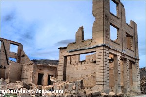
Although the area produced well over a million dollars (historic dollars) of bullion during its first three years, declining high-grade ore (as assessed in 1908) along with devalued stocks steadily decreased the value of the areas holdings.
As mines in the district reduced production or shut down, unemployed miners left to seek work elsewhere.
The towns banks closed, businesses failed and by 1910 the population of Rhyolite had fallen to fewer than 700 individuals.
The last major mine closed in 1911. The newspapers and post office closed by 1913 and the last train left Rhyolite Station in the summer of 1914.
By 1916 the electricity was turned off and the power lines removed.
Within a year Rhyolite was all but abandoned.
The 1920 census reported a population of only 14 individuals with the last resident (a 92-year old man) passing in 1924.
Much of Rhyolite’s remaining infrastructure was utilized as building material for other towns and mining camps.
Whole buildings and two-room cabins were moved and reassembled.
The Miners’ Union Hall in Rhyolite became Beatty’s Old Town Hall and parts of many buildings were used to build a Beatty school.
Today, Rhyolite is maintained by the Bureau of Land Management and is one of the most photographed ghost towns in the West.
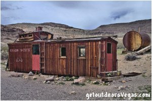
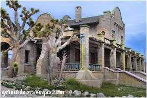
Notable ruins include the railroad depot, an old caboose, the “Bottle House” and (slightly south of town) the Rhyolite-Bullfrog cemetery with many wooden headboards.
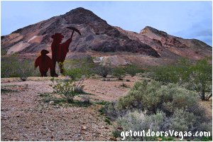
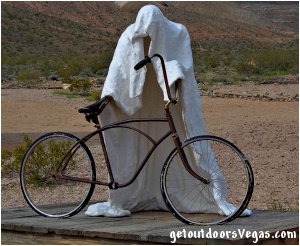
The Goldwell Open Air Museum (established in the early 1990’s) preserves an outdoor sculpture park located near the ghost town of Rhyolite and is ranked among one of the most unique places to experience art.
Founded in 1984 by the late Albert Szukalski (1945-2000), the site features exceptionally large sculptures created by a group of well-known Belgian artists.
Within this collection is a ghost like depiction of the “Last Supper”, a 25-foot tall pink woman and a 24-foot tall sculpture of a prospector and penguin, along with other large exhibits.
The sculpture park is open to the public all day, every day with no admission fee.
There is a “visitor center” on site with historical exhibits and a small gift shop (open certain weekends during the summer months).
The museum sits on private property and the artworks on display are protected by copyright.
Non-commercial photography for personal use is permitted at any time.
Commercial photography, film and video recording requires permission from the property owners.
Tips:
There are full services available in Beatty, Nevada (5 miles east of Rhyolite).
A primitive restroom facility is located near the historic railroad station (no other facilities).
Remember a full tank of gas, bring water, snacks, sunscreen, a hat and your camera.
Look for wild horse and burro in the hills, be aware of snakes.
This adventure would be a great side-trip while in route from Death Valley National Park to the Beatty area.
..........
nearby: Swiss Cheese Outcropping
Directions:
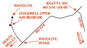
From the intersection of US-95 and NV-374 in downtown Beatty head Southwest on NV-374 for 4.0 miles to the turnoff for Rhyolite Road (paved).
Turn North (right) up Rhyolite Road for 1.1 miles to the Goldwell Open Air Museum entrance.
Continue North on Rhyolite Road an additional 0.7 miles passing thru Rhyolite to pavements end and the historic railroad station.
Return by reversing route.
Approximately 120 miles from central Vegas Strip via I-15 (North) and US-95 (North) to Beatty, Nv.
