Grapevine Canyon
Petroglyphs
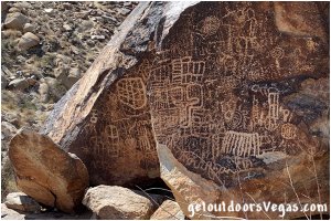
The Grapevine Canyon Petroglyphs (located within the southerly extents of Lk. Mead National Recreation Area) are listed on the United States National Register of Historic Places (1984).
While visible throughout the canyon, a significant concentration lies at the "downstream" entrance (mouth) of Grapevine Canyon itself.
The area features an estimated 250 rock-art panels containing over 700 petroglyphs and many rock shelters which were utilized by historic peoples.
The petroglyphs were created between 1000 and 1900 AD and most depict abstract forms, the meaning of which has been lost to time.
Others depicting representational forms such as bighorn sheep and humans are also present but not abundant.
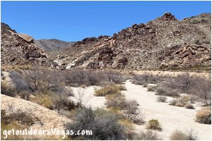
As one starts the short 0.25 mile hike from the trailhead (westerly end of the parking area), the mouth of Grapevine Canyon is visible (see photo above).
At the trailhead an informational sign gives a brief description of the areas significance to the indigenous peoples and the animal, plant and water resources which attracted them.
To access Grapevine Canyon descend into the wash (usually dry) and follow it "upstream" (Westerly) to the canyon's mouth.
Upon "entering" the canyon petroglyphs can be seen on either side of the wash, many of which are at eye-level and easily seen.
Many more (often better) petroglyphs are higher on the canyon walls and scattered along the Easterly facing slopes that run left (South) and more significantly to the right (North) of the canyon's mouth.
Petroglyphs within the immediate area are easily reached (scrambling - off trail).
For those deciding to venture off trail avoid disturbing the lower petroglyphs, touching and or climbing on the artwork causes great damage.
Better yet: to avoid resource damage utilize a camera with a zoom lens or have a pair of binoculars with you.
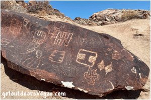
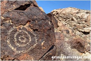
...petroglyphs
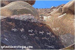
Tips:
Amenities at trailhead are limited to a restroom facility and informational sign.
Remember water: not available at Grapevine Canyon, snacks (picnic lunch), sunscreen, a hat, sturdy shoes and your camera.
Keep an eye out for wildlife: there are Bighorn Sheep, coyote, cottontail, ground squirrel and lizards around (watch for snakes).
This adventure would be a great "stopover" while in route to / from the Vegas, Laughlin area.
..........
nearby: Hiko Spring
nearby: Laughlin Labyrinths
Warning:
This adventure involves travel to a relatively remote area, please refer to the section on desert travel for safety information.
Avoid the area during extreme heat.
Make sure you have plenty of water, a full tank of gas and a fully pressurized spare tire.
Remember you are responsible for your own safety.
Directions:
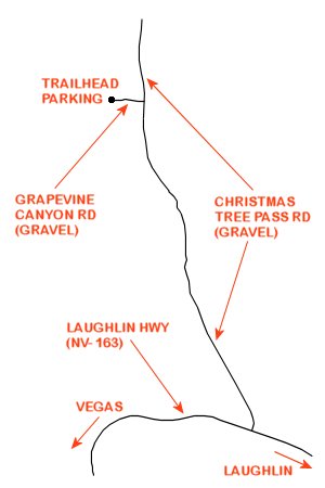
From the US-93 / I-11 interchange with US-95 (just West of Boulder City) head South on US-95 traveling 54 miles+- to the intersection of NV-163 (Laughlin Hwy).
Turn Left (East) onto NV-163 traveling 13 miles+- to the intersection of Christmas Tree Pass Road (gravel - sign marks the turnoff).
NOTE: There is no dedicated left turn lane, be aware of traffic behind you, if necessary consider stopping on the right shoulder and wait for traffic to clear (speed limit 65mph).
Turn Left (North) onto Christmas Tree Pass Road traveling 1.9 miles+- to the intersection of Grapevine Canyon Road (gravel - sign marks the turnoff).
Turn left (West) onto Grapevine Canyon Road traveling 0.2 miles+- to roads end (parking area / trailhead).
Note: Christmas Tree Pass Road and Grapevine Canyon Road are gravel roads and can be "rough" but are typically passable for most "medium" clearance vehicles if driven slowly (use your own judgment).
Return by reversing route.
NOTE: For those returning to Vegas from Laughlin.
From the intersection of NV-163 and S. Casino Drive in Laughlin, head West on NV-163 for 6.1 miles+- to the turnoff for Christmas Tree Pass Road (gravel - sign marks the turnoff).
Turn Right (North) onto Christmas Tree Pass Road traveling 1.9 miles+- to the intersection of Grapevine Canyon Road (gravel - sign marks the turnoff).
Turn Left (West) onto Grapevine Canyon Road traveling 0.2 miles+- to roads end (parking area / trailhead).
