Fletcher Canyon Trail
Spring Mtns. Natl. Rec. Area
Overview:
The Spring Mountains National Recreation Area (SMNRA), administered by the U.S. Forest Service (Humboldt-Toiyabe Natl. Forest), is located west of Las Vegas, Nevada.
The SMNRA encompasses over 316,000 acres (494 sq. miles+-) with elevations ranging between 3,000 feet and Southern Nevada's highest peak, Mt. Charleston (11,918 ft).
Because of it's wide range in elevation, the SMNRA encompasses an amazing array of life zones.
These diverse life zones support a wide variety of wildlife including deer, elk, mountain lion, wild horses, bobcat, desert bighorn sheep, chipmunks, butterflies and many species of birds.
Desert dwelling plants like sagebrush and Joshua Trees dominate the desert life zone at lower elevations.
Ascending to mid-elevations, desert vegetation is replaced by a Pinyon-Juniper ecosystem and eventually by forests of Ponderosa Pine and other coniferous trees.
Bristlecone Pines, possibly the world’s oldest living organisms, appear at treeline.
Of interest, the Spring Mountains support twenty-five plant and animal species found nowhere else on earth.
Often described as an "oasis" in the harsh, dry and unforgiving Mojave Desert - the Spring Mountains provide a diverse ecosystem for animal and plant life while offering a rare retreat for visitors wanting to escape the heat (typ. 20°F cooler) of the Las Vegas Valley.
The Fletcher Canyon Trail is a "gradual" uphill (moderate) hike, good for most hikers and families, which travels thru a diverse forested canyon while "paralleling" a usually dry (intermittent) wash up Fletcher Canyon to the Fletcher Canyon Narrows.
The hike begins in a forested environment with peek-a-boo views of what is to come.
As one progresses along the trail, views open up with sheer (limestone) cliffs becoming more apparent.
Once in the "narrows" the canyon walls eventually "tighten" to a few feet apart and "tower" up to 200 feet+- above the trail, making this adventure well worth the effort.
Of Note: a portion of this enjoyable and beautiful hike (within the Spring Mountains Natl. Rec. Area) is located in the Mt. Charleston Wilderness Area.
This wilderness area was created to protect endemic plant and animal species that are vulnerable to endangerment (extinction) in the near future: therefore please practice a Leave no Trace mentality during your hiking adventure.
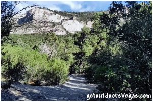
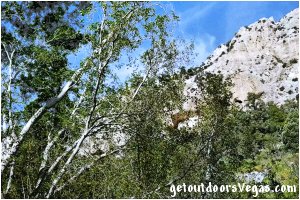
...trailside scenery
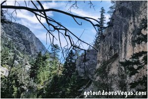
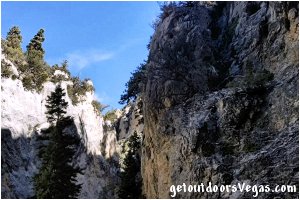
...trailside scenery
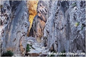
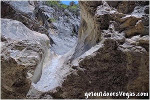
Information / Tips:
This adventure would make a great stopover (a 2 to 3 hr. hike: not ADA accessible) while enjoying the Spring Mountains National Recreation Area.
Bring plenty of water, snacks, a hat, sunscreen, sunglasses and hiking boots (advised).
Make sure you have a full tank of gas and a fully pressurized spare tire.
Note: trailhead parking (especially on weekends) can be challenging with hikers parking along the roadway, get to the trailhead early.
Watch for Pedestrians when driving.
Don't forget your camera.
..........
• Parking amenities (East Lot):
none
8 to 10 spots available (dirt)
• Parking amenities (West Lot):
paved, vault toilet
trash receptacle
20 spots+- available
• Trailhead amenities:
trailhead sign
information kiosk
..........
• Other:
moderate hike, great for older kids
elev. gain: 780 feet+- (trailhead to WP9)
water can be in upper wash (typ. dry)
can be snow (winter to mid spring)
dogs are allowed (on leash)
..........
• Amenities in area:
visitor center, restrooms @ the
Spring Mtns. Visitor Gateway:
located 1.7 miles+- East of the
Fletcher Canyon Trail trailhead
N36.27072 W115.58847
..........
nearby: Desert View Overlook Trail
nearby: Kyle Canyon Slots
Warning:
This adventure involves travel to a relatively remote area, please refer to the section on desert travel for safety information.
• Be mindful of flash floods, lightning
• Rocks in Fletcher Wash can be slippery
(wet or dry conditions)
• Avoid during extreme heat
• You are responsible for your own safety
Trail Directions:
From either parking lot proceed to the nearby crosswalk (watch for traffic) and cross to the North side of Kyle Canyon Rd. (NV-157) to the Fletcher Canyon Trail trailhead (waypoint T).
From the trailhead (waypoint T) walk Northerly along the Fletcher Canyon Trail which eventually turns Northwesterly paralleling Fletcher Canyon Wash (on Southerly side) for a total distance of 0.22 miles+- to where the trail crosses Fletcher Wash and WP1.
From WP1 cross to the opposite (Northerly) side of Fletcher Canyon Wash and continue along the trail for 0.15 miles+- to a trail junction and WP2.
This trail junction is for the Eagle Nest Trail (not described on this web-page) which bears Right (Easterly) and steeply climbs out of the canyon.
From WP2 continue straight (Northwesterly) along the Fletcher Canyon Trail for 0.22 miles+- to a second crossing of Fletcher Wash and WP3.
From WP3 cross to the Southerly side of Fletcher Canyon Wash and proceed up the trail for 0.02 miles+- to a wooden sign (for the Mt. Charleston Wilderness Area) and WP4.
From WP4 continue along the Fletcher Canyon Trail for 0.12 miles+- to a third crossing of Fletcher Canyon Wash and WP5.
From WP5 cross once again to the Northerly side of Fletcher Canyon Wash continuing Northwesterly along the Fletcher Canyon Trail (watch for old rusty historic pipes along the way) for 0.67 miles+- to a forth crossing of Fletcher Canyon Wash and WP6.
Note: observant hikers may notice two old rusty metal pipes (in the wash) which drip water from a seasonal spring located just upstream.
From WP6 the trail runs up the wash for 0.02 miles+- to an "apparent" trail junction (WP7) then bears left to the Southerly side of Fletcher Canyon Wash where it begins a "steep traverse" along the Southerly (very picturesque) side of the canyon.
Once atop this short "steep" section the trail descends back into the wash at the "entrance" of the Fletcher Canyon Narrows.
Note: if the Fletcher Canyon Wash is dry hikers can continue up the wash, if wet cross the wash and follow use-trails "upstream" to where the narrowing canyon walls abruptly turn Right (Northerly) at WP8 (0.25 miles+- distant of WP6).
Note: portions of the route between WP6 & WP8 can be somewhat confusing due to multiple use-trails in the area, look for well traveled trails (often signify routes of previous hikers).
From WP8 continue in a Northerly direction along the trail thru an ever narrowing Fletcher Canyon for 0.20 miles+- to a large boulder (aka the "chute" - see last photo above) that mostly blocks the canyon and WP9, being the end of this trail description.
Note: from the "chute" hikers can continue up canyon for 200 feet+- to a point where the canyon forks and further exploration (not described on this web-page).
Return by reversing route.
Approx. out and back distance (as described): 3.70 miles.
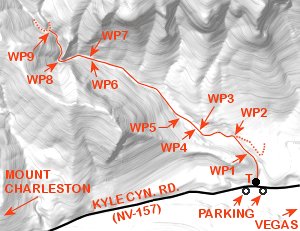
T: N36.26351 W115.61171
trailhead
WP1: N36.26594 W115.61195
wash crossing
WP2: N36.26741 W115.61367
trail junction
WP3: N36.26798 W115.61720
wash crossing
WP4: N36.26799 W115.61740
wilderness bdry. sign
WP5: N36.26917 W115.61868
wash crossing
WP6: N36.27381 W115.62781
wash crossing
WP7: N36.27392 W115.62818
"apparent" trail junction
WP8: N36.27357 W115.63112
canyon curves North
WP9: N36.27593 W115.63199
the "chute"
Note:
See desert travel for GPS Waypoint info
All distances and waypoints are approximate
Driving Directions:
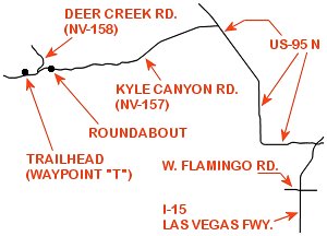
From I-15 (Las Vegas Fwy) at W. Flamingo Rd. head North on I-15 for 4.1 miles+- and merge (utilizing the right 2 lanes) towards US-95 N (Exit #42A).
Continue on offramp for 0.2 miles+- merging Westerly toward US-95 N.
Continue Westerly thru interchange for 0.8 miles+- (utilizing the left 2 lanes) and merge onto US-95 N.
Continue on US-95 N for 15.6 miles+- taking Exit #96 for Kyle Canyon Rd. (NV-157).
At bottom of exit ramp turn left (Westerly) onto Kyle Canyon Rd.
Continue Westerly on Kyle Canyon Rd. for 16.4 miles+- to a roundabout (entrance to Spring Mtns. Visitor Center).
Continue straight (Westerly) thru roundabout for 1.2 miles+- to the intersection of Kyle Canyon Rd. and Deer Creek Rd. (NV-158).
Continue straight (Westerly) on Kyle Canyon Rd. for 0.5 miles+- to the Fletcher Canyon Trailhead area (marked by pedestrian crosswalk and signs).
Trailhead parking is located on the left (South) side of Kyle Canyon Rd. just East and West of pedestrian crosswalk.
Return by reversing route.
Approx. 39 miles+- from central Las Vegas Strip to the Fletcher Canyon Trailhead.
