Desert View Overlook Trail
Spring Mtns. Natl. Rec. Area
Overview:
The Spring Mountains National Recreation Area (SMNRA), administered by the U.S. Forest Service (Humboldt-Toiyabe Natl. Forest), is located west of Las Vegas, Nevada.
The SMNRA encompasses over 316,000 acres (494 sq. miles+-) with elevations ranging between 3,000 feet and Southern Nevada's highest peak, Mt. Charleston (11,918 ft).
Because of it's wide range in elevation, the SMNRA encompasses an amazing array of life zones.
These diverse life zones support a wide variety of wildlife including deer, elk, mountain lion, wild horses, bobcat, desert bighorn sheep, chipmunks, butterflies and many species of birds.
Desert dwelling plants like sagebrush and Joshua Trees dominate the desert life zone at lower elevations.
Ascending to mid-elevations, desert vegetation is replaced by a Pinyon-Juniper ecosystem and eventually by forests of Ponderosa Pine and other coniferous trees.
Bristlecone Pines, possibly the world’s oldest living organisms, appear at treeline.
Of interest, the Spring Mountains support twenty-five plant and animal species found nowhere else on earth.
Often described as an "oasis" in the harsh, dry and unforgiving Mojave Desert - the Spring Mountains provide a diverse ecosystem for animal and plant life while offering a rare retreat for visitors wanting to escape the heat (typ. 20°F cooler) of the Las Vegas Valley.
The Desert View Overlook Trail is a 0.42 mile+- (round trip) concrete paved trail (ADA accessible, stroller friendly) that leads from the parking area to two overlooks with great views of the surrounding desert and mountains.
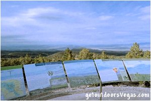
From the Overlook Parking Area, the trail runs northerly as it gradually winds downslope to the overlooks which have educational panels (others along trail) with information about the area, views and history of the site.
Historically, the overlook area was a great vantage point for viewing atomic bomb blasts during the Atomic Era with many of the educational panels providing information about this bygone time.
Today, visitors might see U.S. Air Force maneuvers (Nellis Bombing Range) over the valley far below.
Other panels along the trail (and at the overlooks) provide information about the flora, fauna and geology of the surrounding area and help to identify the mountains and other landmarks that can be seen in the distance.
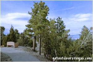
For visitors, the Desert View Overlook Trail (requires very little effort) with its concrete surface, gentle slopes and trailside benches is the perfect place to take in views of the Mojave Desert, providing great scenery and a bit of history too.
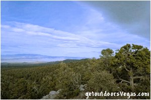
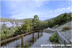
...trailside scenery
Information / Tips:
This adventure would make a great stopover (45 min+- walk: ADA accessible with moderate grades) while enjoying the Spring Mountains National Recreation Area.
Bring plenty of water, snacks, a hat, sunscreen, sunglasses and comfortable shoes.
Make sure you have a full tank of gas and a fully pressurized spare tire.
Dogs are permitted on trail (leash).
Don't forget your camera.
..........
• Parking amenities:
paved (no other amenities)
9 parking stalls + 1 ADA stall
1 oversized parking stall (bus, RV)
• Trailhead amenities:
trailhead sign
information sign
• No fees
• Open 24/7 (subject to road conditions)
• Restrooms @ Deer Creek Picnic Area
(see driving directions below)
• Kid and stroller friendly
..........
nearby: Fletcher Canyon Trail
nearby: Kyle Canyon Slots
Warning:
This adventure involves travel to a relatively remote area, please refer to the section on desert travel for safety information.
• Be mindful of flash floods, lightning,
high winds, ice or snow (seasonal)
• You are responsible for your own safety
Trail Directions:
From the trailhead (waypoint "T") walk along the concrete pathway in a Northerly direction for 0.07 miles+- to the first of two overlooks (WP1).
From WP1 continue along the pathway (moderately downslope) in a Southerly direction to a switchback where the pathway abruptly turns and begins running in a Northerly direction.
Shortly after, the pathway passes thru two additional switchbacks as it generally follows its "Northerly" course to the second of two overlooks (WP2) being 0.14 miles+- distant of WP1 and the end of the concrete pathway (trail description).
Return by reversing route.
Approx. walking distance (as described): 0.42 miles+- out and back.
..........
Pathway (trail) amenities:
overlook platforms (2)
informational signs
trailside benches
360° views
..........
Pathway (trail) Elev. Profile:
waypoint "T" to WP1: essentially flat
WP1 to WP2: -35 feet+- (moderate downslope)
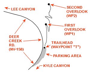
T: N36.33675 W115.62878
trailhead
WP1: N36.33775 W115.62873
first overlook
WP2: N36.33861 W115.62858
second overlook
Note:
See desert travel for GPS Waypoint info
All distances and waypoints are approximate
Driving Directions:
From I-15 (Las Vegas Fwy) at W. Flamingo Rd. head North on I-15 for 4.1 miles+- and merge (utilizing the right 2 lanes) towards US-95 N (Exit #42A).
Continue on offramp for 0.2 miles+- merging Westerly toward US-95 N.
Continue Westerly thru interchange for 0.8 miles+- (utilizing the left 2 lanes) and merge onto US-95 N.
Continue on US-95 N for 15.6 miles+- taking Exit #96 for Kyle Canyon Rd. (NV-157).
At bottom of exit ramp turn left (Westerly) onto Kyle Canyon Rd.
Continue Westerly on Kyle Canyon Rd. for 16.4 miles+- to a roundabout (entrance to Spring Mtns. Visitor Center).
Continue straight (Westerly) thru roundabout for 1.2 miles+- to the intersection of Kyle Canyon Rd. and Deer Creek Rd. (NV-158).
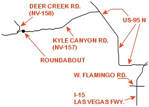
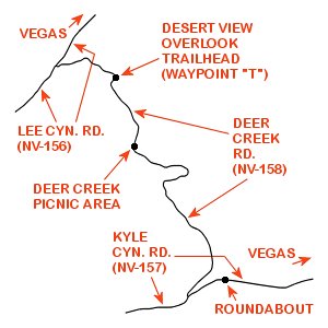
From the intersection of Kyle Canyon Rd. and Deer Creek Rd. turn Right (Northerly) onto Deer Creek Rd. traveling 5.50 miles+- to the Deer Creek Picnic Area parking lot (Right side of road - sign in lot) where a restroom facility is available (if needed).
Note: this parking area is on a curve with a crosswalk (watch for pedestrians).
From the Deer Creek Picnic Area, continue Northerly on Deer Creek Rd. traveling an additional 2.30 miles+- to the Desert View Overlook parking area (signed - on Right side of road).
Return by reversing route.
Approx. 46 miles (as described above) from the central Las Vegas Strip to the Desert View Overlook parking lot and trailhead.
Note: from the Desert View Overlook parking area travelers can return to Vegas by continuing Northerly on Deer Creek Rd. and turning Right (Northeasterly) on Lee Canyon Rd. (NV-156) then Easterly on US-95 N.
This alternate return route (not fully described on this webpage) is approx. 50 miles from the Desert View Overlook parking area to the central Las Vegas Strip.
