Petroglyph Canyon Trail
Sloan Canyon Natl. Conservation Area
Overview:
A network of trails cross thru the Sloan Canyon National Conservation Area with the Petroglyph Canyon Trail being the subject of this web-page.
During cooler months full-sun hikes within Petroglyph Canyon and throughout the Conservation Area are warm and very enjoyable.
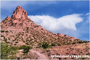
Landscapes within the Conservation Area range from "lowland" expanses bisected by eroded washes to volcanic peaks exceeding 5,000 feet in elevation.
From the trailhead the Petroglyph Canyon Trail eventually descends into a shallow wash and follows the Petroglyph Trail (upstream) through a small canyon to the petroglyph site and beyond, then exits the wash looping back along the Cowboy Trail to re-intersect the wash, eventually returning (via the Petroglyph Trail) to the trailhead - see trail map below.
Sloan Canyon National Conservation Area (designated Nov. 2002) is administered by the U.S. Bureau of Land Management.
The Conservation Area protects 48,438 acres of scenic and geologic treasures with an amazing collection of petroglyphs covering several thousand years of history: native peoples to 19th-century settlers.
Located on the southerly edge of the Las Vegas Valley, adjacent to Henderson's southerly boundary, the Conservation Area includes the "dark" volcanic mountains / ridges that can be seen from most areas around the Las Vegas metropolitan area.
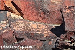
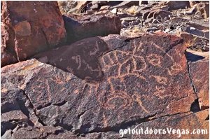
The Conservation Area is best known for the Sloan Canyon Archaeological District which includes the Sloan Petroglyph Site (listed on the National Register of Historic Places - Dec. 1978).
With a majority of the areas 300+ separate rock-art panels and around 1,700 individual designs located in Petroglyph Canyon proper, the canyon is recognized as one of the most important Native American cultural sites in Southern Nevada.
Within Petroglyph Canyon a majority of the rock-art is concentrated along both sides of a 400 foot+ stretch of the canyon often referred to as the Petroglyph Gallery.
The petroglyphs are etched into the weathered patina (desert varnish) which covers the volcanic boulders that are scattered throughout the area, with many designs being large, clear and easy to locate.
The rock-art varies greatly with human-like (anthropomorphic) figures, animals, hunting scenes and geometric shapes represented.
Sloan Canyon National Conservation Area supports a variety of wildlife species.
Seeing any given animal will be totally dependent on the date and time of your visit.
As with many desert species extreme heat limits viewing opportunities, morning or late-afternoon hours are best (Note: rattlesnakes are more active during these times).
Some species are shy / afraid of humans, some are nocturnal or seasonal.
Scan your surroundings, wildlife is always around although not necessarily apparent.
Mammals (commonly seen):
Antelope Ground Squirrel
Cottontail Rabbit, Jackrabbit
Bat, Coyote, Desert Bighorn Sheep, Mule Deer
Mammals (nocturnal / rarely seen):
Desert Kangaroo Rat, Grey & Kit Fox
Bobcat, Mountain Lion
.....
Reptiles (commonly seen):
Side Blotched, Collard & Zebra Tailed Lizard
Chuckawalla (lizard), Desert Tortoise (summer)
Rattlesnake, Sidewinder & non-venomous snakes
Reptiles (rarely seen):
Gila Monster (venomous)
.....
Birds:
Black-Throated Sparrow, hummingbird
Cactus Wren, Gambel's Quail, Mourning Dove
Loggerhead Shrike, Phainopepla
Red-Tailed & Swainson's Hawk, Roadrunner
Vegetation within the Conservation Area is typical Mojave Desert Scrub: Joshua Tree, yucca, creosote bush, chaparral, mesquite and cactus.
In addition, the area is a great place to view wildflowers (Mar. to May - especially after wet years).
Some of the main plants that characterize the area include Beavertail Cactus, Brittlebush, Creosote Bush, Globemallow, Mojave Yucca, Teddy Bear Cholla and White Desert Primrose.
Information / Tips:
Bring plenty of water / snacks, hat, sunscreen, sunglasses, hiking boots (advised), gloves (scaling pour-overs) and don't forget your camera.
Please admire the petroglyphs from afar, climbing on or even touching the artwork causes great damage: Stay on the Trails - Leave no Trace.
.....
Note: day use only
Entrance Fee: None
No shade (avoid extreme heat)
Be aware of snakes
Cell phone coverage (poor or unavailable)
Dogs prohibited - Service Animals welcome
Motorized vehicles prohibited
Bicycles prohibited
Drones prohibited
Hunting / target practice prohibited
.....
nearby: Seven Magic Mountains
Warning:
This adventure involves travel to a relatively remote area, please refer to the section on desert travel for safety information.
• Be mindful of flash floods
• Avoid during extreme heat
• You are responsible for your own safety
Trail Directions:
Nawghaw Poa Road (see driving directions below) is controlled by a gate providing access to the trailhead and the Sloan Canyon Visitor Contact Station.
Note: the gated road opens / closes on the same schedule as the Contact Station.
When the Contact Station is closed you can still access the Petroglyph Canyon Trailhead by parking on Democracy Drive and hike 0.7 miles+- to the trailhead (adds a total of 1.4 miles+- to hike).
• June-Sept: 8:30am-4:30pm (Fri thru Sun)
• Oct-May: 8:30am-4:30pm (Every Day)
• Thanksgiving: 8:30am-12:30pm
• Christmas: 12:30pm-4:30pm
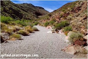
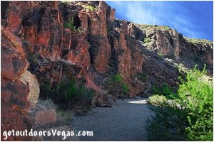
...trailside scenery
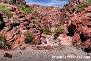
From the trailhead on the east side of the Contact Station (southerly end of Nawghaw Poa Road), walk southwesterly climbing a gentle grade for 0.21 miles+- to an "Old Jeep Trail" and WP1.
Turn left (southeasterly) following the trail, gently ascending then eventually descending via two long switchbacks, for a distance of 0.36 miles+- entering a sandy wash (BLM 100 - Petroglyph Trail) and WP2.
Travel "upstream" (southerly) on BLM 100 following the "winding" wash for 0.76+- miles to the junction of BLM 100-BLM 200 and WP3.
Continue "upstream" on BLM 100 for 0.16 miles+- to the vicinity of an easily negotiated 6-8 foot high pour-over and WP4.
This pour-over can be bypassed by a use-trail (east edge) or by scrambling up the pour-over itself (rocks can be slippery).
Continuing "upstream" on BLM 100, observant individuals will begin to see sporadic petroglyphs along the steepening canyon walls.
After an abrupt turn to the right hikers enter the "narrows" portion of the wash and arrive at WP5 after traveling an approx. distance of 0.24 miles.
Within the "narrows" three short 4-8 foot high pour-overs (easily negotiated) followed by a 10-foot high pour-over must be scaled (rocks can be slippery).
Scaling the pour-overs on the center-left side is recommended (use your own judgment).
Atop the 10-foot high pour-over the "petroglyph gallery" truly begins and continues "upstream" (approx. 400 feet) thru an immediate left (southerly) jog and widening canyon.
Departing the pour-over continue into the "center" of the petroglyph gallery and WP6, having traveled approx. 0.06 miles "upstream" of WP5.
Within this area look for heavy concentrations of petroglyphs on both sides of the canyon at various levels and locations.
Continuing on BLM 100 "upstream" from WP6 the wash eventually arcs right (southwesterly) and at just under 0.15 miles intersects with a second wash at WP7.
Beyond WP6 heading to WP7 petroglyphs can be seen although not as dense as in the petroglyph gallery itself.
Continuing "upstream" on BLM 100 the wash winds in a southwesterly then westerly direction for 0.29 miles+- to the junction of BLM 100-BLM 200-BLM 300 and WP8.
At this point BLM 100 ends and BLM 300 (Hidden Valley Trail - not discussed in this web-page) heads in a southwesterly direction.
Turn right, leave the main wash and follow BLM 200 (Cowboy Trail) in a northerly direction, climbing for 0.21 miles+- to a high point (saddle) and WP9.
From this high point there are nice views of the Las Vegas Valley and surrounding area.
Continue on BLM 200, descending thru a small section of switchbacks while progressing northerly for approx. 0.30 miles to WP10.
From WP10 follow BLM 200 downslope (northeasterly) for approx. 0.24 miles to the junction of BLM 100-BLM 200 and WP3.
From WP3 reverse your previous route (WP3-WP2-WP1-trailhead) for approx. 1.33 miles to the Sloan Canyon Visitor Contact Station, trailhead and parking area.
Note: pour-overs always look higher and are somewhat harder to "climb down" - therefore the full hike (as described above) is RECOMMENDED.
..........
Technical Note: A pour-over (dry waterfall) typically occurs at rocky ledges where water (if flowing) would form a waterfall.
As mentioned in the "RECOMMENDED" trail directions, just upstream of WP4 one must scale a Class 2 pour-over.
Additionally, within the "narrows" upstream of WP5 one must scale 3 additional Class 2 pour-overs followed by a "minimal" Class 3 pour-over.
Ratings by "CLASS" refer to the technical difficulty of a route, ranging from Class 1 (e.g. well-maintained trail) to Class 6 (use of climbing gear - highly technical).
With a Class 2 rating the first 4 pour-overs (4-8 feet high) are scrambles which "may require" minimal use of hands for stability and do not involve a risk of falling.
The 5th "minimal" Class 3 pour-over (10 foot high) will involve (for most people) the use of hands for stability and "could" include a short fall (onto sand) if one were not attentive.
Pour-overs can be "slippery" due to the effect of water polishing the rock, use care and your own discretion when scaling (keep an eye on the little ones).
Realistically, "kids" of all ages will have no problem conquering these obstacles - remember you are responsible for your own safety.
..........
Route Alternatives:
(1) Individuals wanting an "out and back" alternative would need to "reverse course" upon reaching the Petroglyph Gallery.
This shortens the hike (as described above) by 0.7 miles+- and decreases the total elevation gain / loss by approx. 300 feet.
For those considering this alternative, once atop each pour-over access your comfort level for descending on your return.
Considering your parties comfort level, allow time to hike the entire route (as described above) if necessary.
(2) Diverting to the Cowboy Trail (BLM 200) at WP3 and hiking BLM 200 to WP8 (reconnects to BLM 100) allows one to access the Petroglyph Gallery from the South (return by reversing course).
This route (avoids pour-overs) lengthens the hike compared to the "recommended" route by 0.8 miles+- and increases the total elevation gain / loss by approx. 300 feet.
..........
Trail Summary (distance):
RECOMMENDED (ascend pour-overs): 4.3 miles+-
Alt.1 (ascend / descend pour-overs): 3.6 miles+-
Alt.2 (avoid pour-overs): 5.1 miles+-
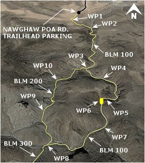
BLM 100 = PETROGLYPH TRAIL
BLM 200 = COWBOY TRAIL
BLM 300 = HIDDEN VALLEY TRAIL
..........
WP1: N35.91367 W115.12745
intersect "Old Jeep Trail"
WP2: N35.91079 W115.12408
enter sandy wash (BLM 100)
WP3: N35.90151 W115.12509
jct. BLM 100-BLM 200
WP4: N35.89998 W115.12341
first pour-over
WP5: N35.89762 W115.12321
the "narrows"
WP6: N35.89741 W115.12395
petroglyph gallery
WP7: N35.89538 W115.12398
washes merge
WP8: N35.89419 W115.12770
jct. BLM 100-BLM 200-BLM 300
WP9: N35.89651 W115.12809
high point (saddle)
WP10: N35.89970 W115.12750
waypoint (BLM 200)
Note:
See desert travel for GPS Waypoint info
All distances and waypoints are approximate
Driving Directions:
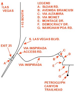
From I-15 (Las Vegas Fwy) at W. Flamingo Rd. head South on I-15 for 12.5 miles exiting freeway at Sloan Rd. (Exit #25).
At bottom of ramp turn left (East) onto Sloan Rd. traveling 600 feet to the intersection of Sloan Rd. and S. Las Vegas Blvd.
Turn left (North) onto S. Las Vegas Blvd. traveling 0.6 miles to the intersection of Via Inspirada Access Rd.
Turn right (East) on Via Inspirada Access Rd. (transitions into Via Inspirada) traveling a total distance of 3.1 miles to a traffic circle at Avenida Brancusi.
Turn right (South) onto Avenida Brancusi traveling 0.3 miles to the intersection of Via Altamira.
Turn left (East) onto Via Altamira traveling 0.1 miles to the intersection of Via Monet.
Turn right (South) onto Via Monet traveling 0.3 miles to the intersection of Montage Dr.
Turn right (West) onto Montage Dr. traveling westerly then southerly for 0.4 miles to Democracy Dr.
Bear left (East) onto Democracy Dr. traveling 0.5 miles to Nawghaw Poa Rd.
Turn right (South) onto Nawghaw Poa Rd. traveling 0.7 miles to roads end and the Petroglyph Canyon Trailhead.
Return by reversing route.
