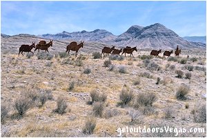
Pack Mule Silhouettes
north of Beaver Dam, Az.

photo: pack mule silhouettes
Overview:
(excerpts from on-site interpretative signs)
• "The Old Spanish Trail was a heavily used trade route that connected the Spanish-speaking communities of northern New Mexico with those in southern California.
Pack trains of 100 or more mules - packsaddles bulging with woolen goods woven in New Mexico - made annual treks between Santa Fe and Los Angeles.
The New Mexican traders bartered their goods for horses and mules and drove large herds back to Santa Fe.
Over time, the Old Spanish Trail also became the primary route for trappers, explorers, prospectors and outlaws crossing the Intermountain West."

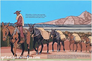
• "Mule packers, or Arrieros, were responsible for the woolen goods of many families.
These goods represented an entire years income."
• "Mules had incredible strength and endurance, fared better than horses where water was scarce and forage poor, and recovered more rapidly after periods of hard work.
Their small tough hoofs withstood the shock and abrasion of rocky, boulder-strewn terrain."
..........
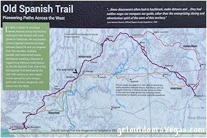
• "In 1829, a Santa Fe merchant named Antonio Armijo led the first mule pack train loaded with trade goods to California.
His successful venture opened commercial trade between Santa Fe and Los Angeles.
Over two decades, multiple, parallel, and intertwined routes developed, creating a network of rugged long-distance trails knows as the Old Spanish Trail.
Use of the Old Spanish Trail declined by the mid-19th century as new wagon routes opened to carry troops, gold-rush miners, emigrants, and others into the West."

• "Antonio Armijo was aged 25 in 1829 when he led the first trading expedition between Abiquiu, New Mexico, and Los Angeles, California.
In blazing his path across the West, Armijo used knowledge gained from American Indians, missionaries, fur trappers, and earlier exploring expeditions."
• "...these discoverers often had to backtrack, make detours and ...they had neither maps nor compass nor guide, other than the enterprising, daring and adventurous spirit of the sons of this territory." (Jose Antonio Chavez, Official Report Armijo Expedition, 1830)
• "The Old Spanish Trail was recognized by Congress in 2002 as the nation's 15th National Historic Trail."
Information / Tips:
While not a true destination and certainly not worth the drive on its own, this adventure would make an interesting stopover (11 mile+- North of I-15) while traveling I-15 between Las Vegas and Salt Lake City.
Bring plenty of water, hat, sunscreen, sunglasses and comfortable shoes.
Make sure you have a full tank of gas and a fully pressurized spare tire.
• Gravel parking area @ WP3
• Interpretative signs @ WP3
• Shoulder parking only @ WP4
- no interpretative signs
- see driving directions (Note 1)
• NO water or restroom facilities
• Not ADA accessible
• Don't forget your camera
..........
nearby: Little Mt. Rushmore
Warning:
This adventure involves travel to a relatively remote area, please refer to the section on desert travel for safety information.
• Watch yourself, your kids and pets near traffic
• Be mindful of lightning / flash floods
• Watch for snakes
• AVOID THE AREA DURING EXTREME HEAT
• You are responsible for your own safety
Driving Directions:
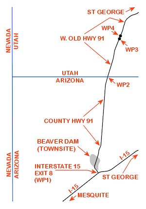
From the I-15 (Las Vegas Fwy) interchange with W. Flamingo Rd. proceed North on I-15 (into Arizona) for a total of 94 miles+- taking Exit #8 for Beaver Dam, Az.
At the end of the off-ramp (WP1) turn Left (Northerly) onto County Hwy 91 traveling 7.8 miles+- to the Arizona / Utah border (WP2) where the highway renames to W. Old Hwy 91.
Continue Northerly on W. Old Hwy 91 for 3.1 miles+- to a gravel pullout on your Right (East side of road) and the Old Spanish Trail information signs / Pack Mule Silhouettes.
Approximately 105 miles from central Vegas Strip to the Pack Mule Silhouettes.
..........
Note 1: a second set of Pack Mule Silhouettes (no informational signage) is located 300 feet+- Left (Westerly) of W. Old Hwy 91 at WP4: being 0.42 miles+- Northerly of WP3.
There is no dedicated parking, therefore park along the gravel shoulder (use your own discretion): watch yourself, your kids and pets in this area.
Note 2: Return to Vegas by reversing route. If traveling towards St. George, Ut. there are two options (1) Reverse route to I-15, then drive Easterly on I-15 to St. George, being 39 miles+- distant of WP3 (2) Continue Northeasterly, Easterly and Southeasterly on W. Old Hwy 91 which eventually renames to Santa Clara Dr which renames to W. Sunset Blvd into the Northwest portion of St. George, being 23 miles+- distant of WP3 (not fully described on this webpage).
..........
WP1: N36.89071 W113.92916
exit 8 - interstate 15
WP2: N37.00019 W113.91586
arizona / utah border
WP3: N37.04328 W113.89929
pack mule silhouettes parking
WP4: N37.04886 W113.89651
second set of pack mule silhouettes
Note:
See desert travel for GPS Waypoint info
All distances and waypoints are approximate

