Lone Mountain
Las Vegas, Nv.

Lone Mountain is an isolated rocky butte in the middle of the northwest portion of the Las Vegas valley.
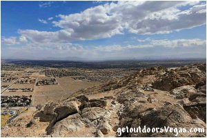
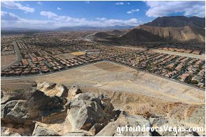
Standing just over 3,300 feet above sea level, Lone Mountain looms above the areas surrounding homes with great views of the city of Las Vegas and surrounding mountains.
Lone Mountain, a "locals" mountain, is surrounded by urban sprawl and offers no solitude or breathtaking wilderness views.
The mountain is however a fine mid-week conditioner.
On typical desert evenings expect to see folks with dogs, couples, kids and tourists hiking to the top.
Graffiti on the summit contributes to the peaks urban feel, complementing the blinding neon of sin city far below.


There are many "unofficial" routes ascending Lone Mountain.
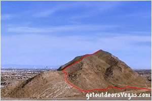
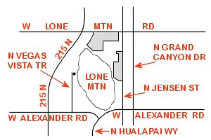
The "standard" route is accessed off of the north end of N. Vegas Vista Trail (see directions / map below).
From the trail-head look for a well-worn trail coming down from a gully on the mountain's westerly side.
Follow this "use trail" arching upward and somewhat clockwise over scree and crumbling limestone to the summit.
About halfway up is a concrete bench, great for a water break and breather if needed.
At times the upper trail is apparent, but not obvious with some minor scrambling required.
The trail is relatively short and very steep, watch for loose rock (especially on your descent - slips and skinned palms).
Trail statistics: moderately difficult, just over 1 mile round trip, elevation gain / loss (approx. 550 feet), dog friendly, no fees or permits required.
Around the base of Lone Mountain is a "perimeter trail" which provides a nice, not quite level hike that circumnavigates the peak. This trail can be accessed from the west trail-head (see directions below) as well as Lone Mountain Park (located on the mountains east side - 4401 N. Jensen St). This popular multi-use loop trail (approx. 2.3 miles in length) consists of hard-packed granite tread averaging 10 feet in width and is utilized by equestrians, bicyclists, runners and hikers. Lone Mountain Park amenities include restrooms, shaded picnic tables, playground structures, paved walking paths, equestrian center (check with park website), tennis courts and even a roller-blade oriented hockey rink. Both trails are often combined (approx. 3.3 miles) and enjoyed by many.
Tips:
No shade, summer hiking is not recommended.
Bring plenty of water and some snacks.
Sturdy footwear (boots) and gloves (protects hands on sharp rocks) are advised along with a hat, sunglasses and sunscreen.
Make sure to bring your camera and (if you have them) binoculars.
Don't be surprised, there might be a drone or two flying around.
Parking is free, there are no restroom facilities at the west trail-head (north end of N. Vegas Vista Trail) or along hike (restrooms are available at Lone Mountain Park).
Don't leave valuables in your car, especially if planning your hike during sunrise or sunset.
..........
nearby: Floyd Lamb Park
Directions:
From S. Las Vegas Blvd. (the Strip) head west for 0.6 miles on W. Flamingo Rd.
Turn left (south) onto Southbound I-15 traveling (in the right 2 lanes) for just over 1 mile taking ramp for (exit 36) Russell Rd.
Continue south on exit 36 veering left at offramp for Russell Rd (follow signs for I-15 South) traveling a total of just under 2 miles and veer right onto County Rd. 215 West.
Continue on County Rd. 215 West, transitioning onto County Rd. 215 North for a total of 20.5 miles taking the exit toward W. Lone Mountain Rd.
Turn right (east) onto W. Lone Mountain Rd. traveling 0.5 miles (passing Lone Mountain Regional Park) to N. Jensen St.
Turn right (south) onto N. Jensen St. traveling 1.0 miles (passing Lone Mountain Park) to W. Alexander Rd.
Turn right (west) onto W. Alexander Rd. traveling 0.3 miles and taking a right to stay on W. Alexander Rd.
Continue along W. Alexander Rd. traveling 0.4 miles to N. Vegas Vista Trail.
Turn right (north) on N. Vegas Vista Trail traveling 0.5 miles to roads end and the Lone Mountain trail-head.
Total distance approx. 27 miles, return by reversing route.

