Keyhole Canyon
Archaeological Site
Overview:
Keyhole Canyon (a small box canyon) has a lot to offer.
An amazing number of petroglyphs, a few pictographs and a 50 foot high pour-over (dry waterfall) at canyon's end.
Most of Keyhole Canyon's rock art images are geometric symbols, but a few petroglyphs depict bighorn sheep, lizards, and humans.
Some archaeologists theorize that the high proportion of these geometric symbols in such a striking location might indicate Keyhole Canyon's importance to the creation beliefs of prehistoric peoples.
In most petroglyph sites the rock art is fairly close to the ground, but within Keyhole Canyon and the immediate area many petroglyphs are unusually high up on the canyon walls.
With many of the petroglyphs at or near ground level there is little need to climb the walls to get a "close-up" view of the higher petroglyphs.
For those deciding to climb to the higher rock art avoid disturbing the lower petroglyphs, touching the artwork causes great damage.
Better yet: to avoid resource damage utilize a camera with a zoom lens or have a pair of binoculars with you.
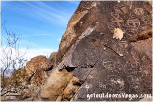
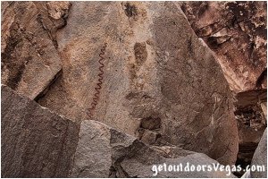
...rock art
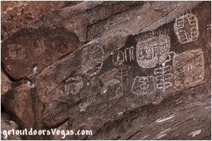
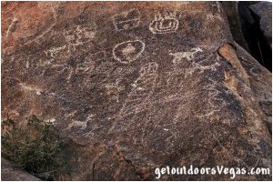
In the Keyhole Canyon area, rock faces - especially those facing South and West, are covered in desert varnish.
Naturally occurring, desert varnish (Patina) is a dark mineral coating that forms over time on the surface of desert rocks.
Native peoples "created" petroglyphs by pecking away (with stone tools) this desert varnish, exposing the light-colored rock hidden beneath.
Native peoples also used pigments to paint images (pictographs), a few of which can still be seen.
While there’s some disagreement on which group left the rock art, many experts agree that the Zunis, Paiute, Mohave and Anasazi / Pueblo all traveled thru this area at some point in time.
A majority of the petroglyphs in the Keyhole Canyon area are located on the North wall of the canyon proper and on the West facing cliffs and boulders lying just North of the canyon's mouth.
Other petroglyphs can be seen (South of the canyon's mouth) on the West facing wall above the parking area.
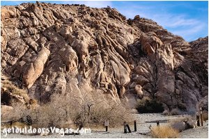
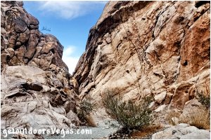
Keyhole Canyon is eroded from the Northwesterly face of a "near" vertical granitic ridge that rises abruptly from the desert floor.
The topography enables visitors to drive up to and park at the base of impressive cliffs that makeup Keyhole Canyon's mouth and trailhead (see driving directions below).
The canyon is about 150 feet wide at it's mouth.
As one hikes "upstream" the canyon's gravel-bottomed gorge continuously narrows and abruptly ends (about 500 feet upstream) at a 50 foot high water-sculpted and water-polished pour-over.
At the base of the pour-over, a small rocky basin (tinaja) has formed.
A tinaja, an American Southwest term for surface pockets carved out by sand and gravel in intermittent streams, traps and holds water during dry periods.
Tinajas have always been a valuable resource for Native Americans, settlers and wildlife in the desert Southwest region.
If water is present, please respect (do not contaminate) this critical resource.
Our "wild" friends will thank you in their own unique and special way.
This aforementioned pour-over effectively prohibits visitors from further upstream travel and services as a turn around point for this adventure.
Information:
A full tank of gas is a must, make sure your spare tire is properly inflated, there is minimal to no cell coverage in the area.
Come prepared, there are no facilities anywhere near this location.
Bring plenty of water / snacks, hat, sunscreen, sunglasses and hiking boots (advised).
Don't forget your camera.
Binoculars (or a zoom camera / lens) would be handy, with many of the petroglyphs being high up on the canyon walls and hard to see.
Please admire the petroglyphs from afar, climbing on or even touching the artwork causes great damage: Leave no Trace.
• Keyhole Canyon is always open
• No fee(s) required
• Not ADA accessible
..........
nearby: El Dorado Valley Pet Cemetery
nearby: Nelson Ghost Town
Warning:
This adventure involves travel to a relatively remote area, please refer to the section on desert travel for safety information.
• Be mindful of flash floods
• Avoid during extreme heat
• Watch for snakes
• You are responsible for your own safety
Directions:
From the US-93 / I-11 interchange (just West of Boulder City) head South on US-95 traveling 8.8 miles+- to the turnoff to the town of Nelson (NV-165).
Continue South on US-95 for an additional 5.9 miles+- to the turnoff (indicated by highway sign - only road in area) for an unmarked dirt road (Route "S" - a.k.a. Keyhole Canyon Access Rd.) and WP1.
Turn left (East) crossing the northbound US-95 lanes (watch for oncoming traffic) following (thru cattle guard) the typically graded dirt road (Route "S") for 2.1 miles+- to roads end ("T" intersection - WP2).
Bear right (South) onto a typically graded dirt road (Route "C" - a.k.a. Powerline Rd. #2) traveling "between" two North-South transmission lines for 1.8 miles+- to WP3.
Continuing South on Route "C" travel 0.14 miles+- to WP4.
Continuing South on Route "C" travel 0.12 miles+- to WP5.
Of Note: along Route "C" there are numerous side / service roads (transmission towers) as you progress towards WP3, WP4 and WP5 (stay on the main road).
..........
from WP3:
• just South of 8th tower (T8)
• drive to WP6: partially in sandy wash
(4X4 advised / recommended)
(use your own judgment)
driving dist. WP3-WP6: 0.30 miles+-
from WP4:
• between 8th & 9th towers
• drive to WP6 is in sandy wash
(4X4 advised / recommended)
(use your own judgment)
driving dist. WP4-WP6: 0.25 miles+-
from WP5:
• just South of 9th tower (T9)
• drive to WP6 is a firm / rocky road
(high clearance vehicle recommended)
(use your own judgment)
driving dist. WP5-WP6: 0.28 miles+-
Tips:
For visitors not utilizing a GPS device: starting at WP2 (int. Route "S" @ Route "C") make note of the Transmission Tower (T1) just East of the waypoint.
As you drive South on Route "C" count (including T1) the towers to your left (East).
WP3 is just South of the 8th tower (T8).
WP5 is just South of the 9th tower (T9).
For visitors not wanting to drive any of the three "access roads" to the Parking Area / Trailhead (WP6): park in the vicinity of any of the 3 waypoints (WP3, WP4, WP5) and walk the "access roads" (easy walk - a little over one-quarter mile) to trailhead.
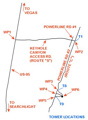
WP1: N35.74405 W114.95565
int. US-95 @ Route "S"
WP2: N35.74330 W114.91900
int. Route "S" @ Route "C"
WP3: N35.71878 W114.92981
int. Route "C" @ 1st Access Pt.
WP4: N35.71684 W114.93069
int. Route "C" @ 2nd Access Pt.
WP5: N35.71523 W114.93141
int. Route "C" @ 3rd Access Pt.
WP6: N35.71546 W114.92661
parking area & trailhead
Note:
See desert travel for GPS Waypoint info.
All distances and waypoints are approximate
Central Vegas Strip to trailhead (44 miles+-)
Return by reversing route
