Goodsprings RR Loop Trail
Goodsprings - Nv.
Overview:
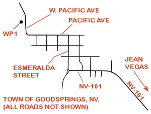
The Goodsprings RR Loop Trail is located on the Northwest edge of Goodsprings, Nv.
This loop trail actually combines two trails, the 1.6 mile+- Goodsprings Ridge Trail and the 0.6 mile+- Yellow Pine Mine Railroad Trail.
Along the Goodsprings Ridge Trail are awesome views across the greater Goodsprings area, with Mt. Potosi to the North and the town of Goodsprings to the Southeast.
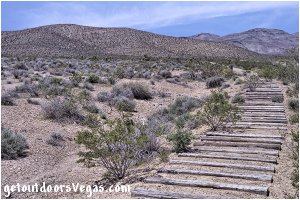
The Yellow Pine Mine Railroad Trail follows a section of a railroad grade (built in 1911) which connected the Yellow Pine Mine to a mill located four miles away in Goodsprings.
Along the loop trail informational signs describe:
• Goodsprings Town History
• Geology around Goodsprings
• Local Mining History and Safety
• the Spring Mountain Range and
the Old Spanish Trail Route
• the Carol Lombard tragedy
• local Flora and Fauna
The Goodsprings RR Loop Trail was built in 2018 by the Bureau of Land Management.
The loop trail (4 foot+- in width) is a smooth / graded "pea gravel" trail which is easy to follow (ample signage) with the Goodsprings Ridge Trail section having steep inclines / declines over its length while the Yellow Pine Mine Railroad section is essentially flat.
Being well maintained, this loop trail provides amazing scenery, history, solitude and a chance to see wildlife while visiting the Goodsprings area.
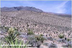
...trailside scenery
Information / Tips:
Bring plenty of water / snacks, hat, sunscreen, sunglasses and hiking boots (advised).
Make sure you have a full tank of gas and a fully pressurized spare tire.
Dogs are allowed on leash.
DON'T forget your camera.
..........
• Goodsprings RR Loop Trail parking amenities:
- gravel parking area, ADA parking
- vault toilet, trash receptacles
- shaded picnic table, info. sign
• Goodsprings RR Loop Trail amenities:
- wide graded trail, easy to follow
- directional signage, info. signs
- mileage markers (1/4 mile increments)
• Goodsprings Ridge Trail:
- not ADA accessible
(very steep sections)
• Yellow Pine Mine Railroad Trail:
- rated as ADA accessible
- minimal elevation gain / lose
(use your own judgment)
• Note:
A few other trails exist Westerly
of the trailhead picnic area
(not described on this web-page)
(see info. sign at trailhead)
• Fees: none
• No Shade on Trail
• No Water Available
..........
nearby: Seven Magic Mountains
Warning:
This adventure involves travel to a relatively remote area, please refer to the section on desert travel for safety information.
• Steep downhill sections of the trail
can be slippery: loose "pea gravel"
• Watch for snakes
• Be mindful of lightning / flash floods
• AVOID THE AREA DURING EXTREME HEAT
• You are responsible for your own safety
Trail Directions:
As previously mentioned the Goodsprings RR Loop Trail (4 foot+- in width) is a smooth / graded "pea gravel" trail which is easy to follow with ample signage.
Therefore, the trail directions presented here are generic in nature with distances between waypoints and a few notes provided to guide hikers.
The "loop trail" can be walked in either direction, being described here in a clockwise direction.
..........
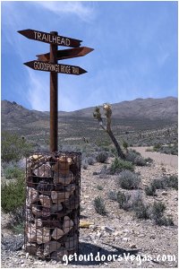
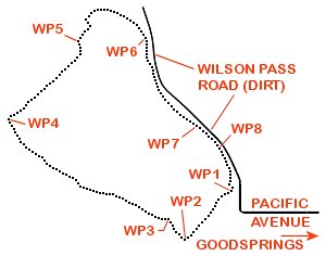
From the Trailhead (WP1) travel in a Southwesterly direction on the Goodsprings Ridge Trail upslope (ignoring other trails) in an ever steepening ascent for 0.22 miles+- to a point where the trail bends sharply Right (Northwesterly) and WP2.
From WP2 continue upslope in a Northwesterly direction along the Goodsprings Ridge Trail for 0.09 miles+- to a trail junction and WP3.
From WP3 bear Left and continue upslope in a Northwesterly direction along the Goodsprings Ridge Trail for 0.63 miles+- to a point where the trail bends sharply Right (Northeasterly) and WP4 (trail's high point).
From WP4 continue in a Northeasterly direction along the Goodsprings Ridge Trail, initially downslope then upslope to a second summit area followed by a steep descent to WP5, being a total distance of 0.35 miles+- from WP4.
From WP5 continue downslope in a Northeasterly direction along the Goodsprings Ridge Trail, traveling thru two moderate switchbacks to a more moderate grade which turns Southeasterly and eventually connects with the Yellow Pine Mine Railroad Trail at WP6, being a total distance of 0.36 miles+- from WP5.
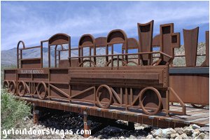
From WP6 travel in a Southerly then Southeasterly direction along the Yellow Pine Mine Railroad Trail (parallels Wilson Pass Road) on a "very slight" downhill grade to a bridge designed to look like a train and WP7, being 0.36 miles+- distant of WP6.
From WP7 continue along the Yellow Pine Mine Railroad Trail paralleling Wilson Pass Road (ignore other trails) for 0.10 miles+- to an area where historic railroad ties are visible and WP8.
From WP8 continue along the Yellow Pine Mine Railroad Trail traveling 0.17 miles+- to the Goodsprings Loop RR Trail Trailhead and WP1.
..........
hiking dist. (as described above): 2.28 miles+-
elev. difference (WP1-WP4): approx. 390 feet
..........
WP1: N35.83645 W115.44103
trailhead
WP2: N35.83424 W115.44372
trail waypoint
WP3: N35.83518 W115.44478
trail junction
WP4: N35.83997 W115.45366
trail waypoint - high point
WP5: N35.84354 W115.44984
trail waypoint
WP6: N35.84384 W115.44607
trail waypoint
WP7: N35.83968 W115.44313
"train" bridge
WP8: N35.83867 W115.44175
historic railroad ties
Note:
See desert travel for GPS Waypoint info
All distances and waypoints are approximate
Driving Directions:
From the I-15 (Las Vegas Fwy) interchange with W. Flamingo Rd. proceed South on I-15 for 25.5 miles+- to Exit #12 (NV-161).
Utilizing the right lane exit onto the Exit #12 offramp, traveling 0.3 miles+- and turn Right onto Westbound NV-161 (Goodsprings Road).
Travel Northwesterly on NV-161 (Goodsprings Road) for 6.9 miles+- into and thru the town of Goodsprings to the intersection of NV-161 and Esmeralda St.
Turn Right (North) onto Esmeralda St. traveling 0.2 miles+- to the intersection of Esmeralda St. and Pacific Ave.
Turn Left (West) onto Pacific Ave. traveling to and thru a 90 degree curve to the Right (W. Pacific Ave.) to the "Goodsprings RR Loop Trail" parking area (on Left) and WP1, being 0.3 miles+- distant of Esmeralda St.
Note: the trailhead parking area is located just North of Clark County Fire Station #78.
Return by reversing route.
Approx. 33.2 miles from central Vegas Strip to the Goodsprings RR Loop Trail Parking Area.
