Desert Natl.Wild.Refuge
Visitor Center & Trails
Overview:
The Desert National Wildlife Refuge (Desert NWR), administered by the U.S. Fish & Wildlife Service, is located North-Northwesterly of Las Vegas.
Created on May 20, 1936 the Desert NWR is the largest wildlife refuge in the conterminous United States.
Originally established at 2.25 million acres, various purchases and admin. "adjustments" (over the years) including 846,000 acres+- "reserved" (1940) for the Department of Defense have affected the wildlife refuge's size.
Today, the Desert NWR encompasses an area of 1.6 million acres+- of southern Nevada's Mojave Desert.
The primary purpose of the Desert NWR is to protect wildlife and wildlife habitat, specifically the Desert Bighorn Sheep.
By constructing or improving year-round water sources Wildlife Managers enhance Bighorn habitat, which in turn benefits many other species.
In addition, managing portions of the refuge as designated wilderness further benefits and protects the areas rich animal and plant habitats.

The principal gateway for visitors visiting the Desert NWR is the Desert NWR Visitor Center.
This 11,000 square foot visitor center which opened in February 2014 contains interpretive exhibits, information on current conditions, knowledgeable rangers, literature and gift shop (see operating hours below).
Several easy to moderate walking and hiking trails begin immediately behind the visitor center (see trail descriptions below) and can be accessed at anytime.
The visitor center and associated trails surround a series of natural springs which bring precious water to the otherwise arid landscape, forming an oasis in the desert.
Along the trails are beautiful old trees, springs, ponds, wetlands, an orchard, historic buildings to include a Refugium (specialized aquarium), desert plant species, wildflowers and endless desert vistas.
Look for resident and migratory birds, mule deer, coyote, bobcat, jackrabbits, squirrels, desert tortoise, lizards, snakes, butterflies and dragonflies.
The best time to view wildlife in this area is early morning during the Spring, Summer and Fall months.
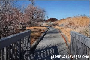
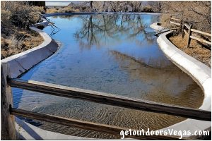
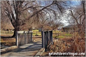
...trailside scenery
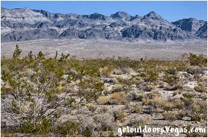
...trailside scenery
Information / Tips:
Bring plenty of water / snacks, hat, sunscreen, sunglasses and comfortable walking shoes.
Make sure you have a full tank of gas and a fully pressurized spare tire.
• Don't forget your camera / binoculars
• Respect Wildlife: you are in their home
Hours: Thur - Mon: 8AM - 4PM
(closed Tue & Wed)
(hours may vary, check website)
(trails open when visitor center is closed)
Admission: Free
Parking: ADA parking, covered parking
Other: Restrooms, trash receptacles
..........
nearby: Floyd Lamb Park
nearby: Kyle Canyon Slots
Warning:
This adventure involves travel to a relatively remote area, please refer to the section on desert travel for safety information.
• Watch for snakes
• AVOID THE AREA DURING EXTREME HEAT
• You are responsible for your own safety
Trails / Points of Interest:
Jackrabbit Loop: an easy trail 0.1 miles+- in length with minimal elevation gain.
This short loop (ADA accessible) travels along the spring fed perennial Corn Creek with a glimpse of the areas cement pond and features a few interpretive signs.
Bighorn Loop: a family friendly trail 0.4 miles+- in length with minimal elevation gain.
This loop (ADA accessible) passes through a desert environment (no shade) with views of the surrounding terrain and distant mountains.
The trail passes a "leftover" length of fence used to pen Desert Bighorn Sheep that were studied during the 50s and 60s.
In addition to interpretative signs the Bighorn Loop provides the best view of the aforementioned cement pond.
Wispering Ben Trail (not ADA accessible): approx. half-way along the Bighorn Loop visitors have the option to follow this single-track out-and-back (total dist. 0.2 miles+-) trail.
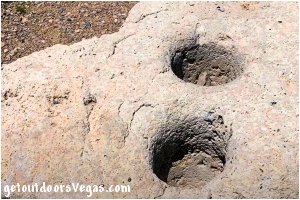
At trails end is a boulder used by native peoples as a morter (grinding stone) for grinding honey mesquite beans.
Coyote Loop: an easy trail 0.3 miles+- in length with minimal elevation gain and shaded sections.
The trail (ADA accessible) features a picnic area, interpretative signs, an orchard area with birding telescopes, and follows portions of the previously mentioned Corn Creek.
Of Note: the Coyote Loop trail passes a "historic railroad tie cabin" and the "Refugium" both of which are described below.
Birdsong Loop (not ADA accessible): this trail 0.5 miles+- in length is an uneven hardpacked dirt track (with sandy stretches) that traces a portion of the refuge's wetlands area.
Along this trail vegetation grows thick with trees and brush in those areas with available moisture.
Other portions of the trail run across open areas of the southern Nevada desert with views of more drought tolerant vegetation and distant mountains.
Due to its relative isolation, the Birdsong Loop is one of the best areas for sighting birds and other wildlife along the Visitor Center trail system.
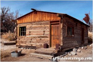
Historic Railroad Tie Cabin: built with railroad ties from the abandoned Las Vegas & Tonopah Railroad, old scars from the railroad spikes still mark the walls of this 1920s historic home.
The cabin has been "somewhat" restored and contains interior furnishings that "date" to its historic time period.
Often open to the public (pre-COVID), the cabin's interior and modest furnishings can be seen thru windows if entry is not allowed.
Refugium: the Refugium is a small building (aquarium) that was build to mimic the natural habitat of the Pahrump Poolfish.
These small "critically endangered" fish were native only to the springpools and streams of the Pahrump, Nevada area and were successfully transplanted to this desert "aquarium" to save the species from extinction due to habitat loss from groundwater pumping in the Pahrump area.
The Refugium has several viewing windows and interpretative signs.
Note: as of the summer of 2021 approx. 650 Pahrump Pupfish were "introduced" into the aforementioned cement pond.
This endeavor required great effort to rid the pond of predatory species such as crayfish, bullfrogs etc.
Please do not introduce any trash or invasive species into this critical habitat.
..........
Total Dist. all trails (1.5 miles+-)
Note: all distances are approximate
Corn Creek Trail Map: click here
Driving Directions:
From I-15 (Las Vegas Fwy) at W. Flamingo Rd. head North on I-15 for 4.1 miles+- and merge (utilizing the right 2 lanes) towards US-95 N (Exit #42A).
Continue on offramp for 0.2 miles+- merging Westerly toward US-95 N.
Continue Westerly thru interchange for 0.8 miles+- (utilizing the left 2 lanes) eventually merging onto US-95 N.
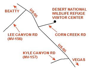
Continue on US-95 N for 15.6 miles+- to the interchange area for Kyle Canyon Rd. (NV-157).
Continue on US-95 N for an additional 9.3 miles+- to Corn Creek Road (signs mark the turnoff).
Turn right (Easterly) onto Corn Creek Road traveling 3.8 miles+- to the Desert National Wildlife Refuge Visitors Center Parking Lot (on your left).
Approx. distance from the central Las Vegas Strip to the Desert National Wildlife Refuge Visitors Center is 34 miles.
Return by reversing route.
