Ash Springs Petroglyphs
Ash Springs, Nv.
Overview:
The Ash Springs Petroglyph Site is located in Lincoln County, Nevada just South of the community of Ash Springs.
This location was frequented by a culture known as the Pahranagats, one of several Southern Paiute groups, and is a "winter site" which accommodated a small village of perhaps 25-40 individuals.
This site is thought to have been a place for visiting, gambling and story-telling.
Other activities were tool making of which knives, drills, scrapers, hammerstones and projectile points were made.
These tools were fashioned mostly out of cherts (hard, fine-grained sedimentary rock) found locally and obsidian's (volcanic glass) from Utah.
Other endeavors included highly specialized basketry specific to the gathering and processing of plant foods.
By contrast, pottery made by the Pahranagat peoples was simple and utilitarian in nature.
In addition, sherds (broken ceramic material) of Fremont-like Greyware (pottery) have been found at Ash Springs, suggesting the presence of these Southwestern groups who co-existed in the area along with the Pahranagats (AD 500-1250).
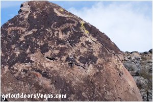
Petroglyphs found at Ash Springs are typical of "rock-art" found throughout the Great Basin Region.
These petroglyphs were "etched" onto rock faces by pecking, abrading, scratching (or a combination of these techniques) which removed dark desert varnish while exposing the lighter rock underneath.
Over time "rock-art" at the Ash Springs Petroglyph Site has been subjected to weathering, natural spalling (flaking) and some human defacement, making some of the "rock-art" faint and harder to see.
Typically "rock-art" is composed of separate motifs (designs) often arranged in groups (panels) on rock faces.
Much of the imagery at Ash Springs is non-representational, its meaning being lost to time.
Other petroglyphs are more recognizable.
For example: petroglyphs representing animals (Zoomorphs) are found at Ash Springs of which Bighorn Sheep are the most commonly seen.
Other recognizable "rock-art" represents human figures (Anthropomorphs) and at Ash Springs exhibit "striking" variations in design.
Petroglyphs "can be" found wherever there has been human activity although most of its meaning is not fully understood, however it can be surmised that it was deeply significant to those who created it.
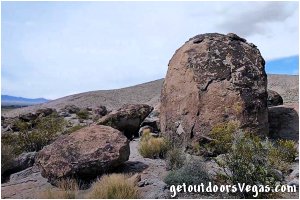
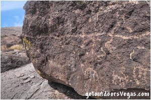
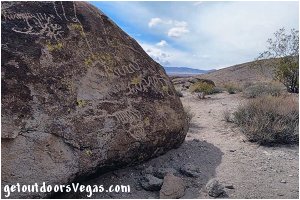
...trailside scenery
Information / Tips:
Bring plenty of water / snacks, hat, sunscreen, sunglasses and hiking boots (advised).
Make sure you have a full tank of gas and a fully pressurized spare tire.
Dogs are allowed on leash.
DON'T forget your camera.
..........
• DON'T TOUCH / DEFACE PETROGLYPHS
• Parking amenities:
none
• Trailhead amenities:
sign-in register, brochure
• Petroglyphs Trail: not ADA accessible
• Fees: none
• No Shade
• No Water Available
Warning:
This adventure involves travel to a relatively remote area, please refer to the section on desert travel for safety information.
• Look for wildlife, watch for snakes
• Be mindful of lightning / flash floods
• AVOID THE AREA DURING EXTREME HEAT
• You are responsible for your own safety
Trail Directions:
From the trailhead / sign-in register (M01) the Ash Springs Petroglyph Site "Trail" meanders thru eighteen specific trail markers.
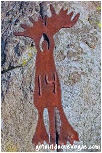
The trail markers are denoted by "small" decorative iron posts (numbered - some are missing) which are approx. 1 foot tall and are supplemented with small diamond shaped "directional" arrow posts at strategic locations.
Throughout the Petroglyph Site there is no "consistently defined" trail (many use-trails exist).
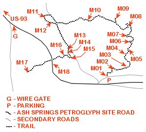
Progress thru the site is "represented" in the map immediately below, with many markers (sites) being grouped "relatively" close to each other.
Therefore, it is suggested to "visually" search (where applicable) for the next numbered marker (typically around boulder outcrops) before proceeding any great distance.
With the "trail" being approx. 0.40 miles in length, visitors should be able to "keep track" of their vehicle location throughout most of the site, making this area perfect for exploration.
..........
Note: any attempt to describe a "usable" trail description would be very confusing, therefore a brief explanation of each markers significance and relative position to each other is presented here.
..........
M01: trailhead / sign-in register
habitation site
M01-M02: Northeasterly, 36 feet+-
M02: petroglyph panel (Bighorn Sheep)
M02-M03: Easterly, 66 feet+-
M03: petroglyph panel, milling stone(s)
M03-M04: Northerly, 63 feet+-
M04: petroglyph panels, domestic activity
grinding slick(s)
M04-M05: Northeasterly, 30 feet+-
M05: petroglyph panel (human figure(s)
M05-M06: Northerly, 41 feet+-
M06: petroglyph panel (female human figure)
grinding slick(s)
M06-M07: Northwesterly, 30 feet+-
M07: petroglyph panel (solar equinox/solstices)
M07-M08: Northerly, 56 feet+-
M08: cobblestone alignment, no petroglyphs
M08-M09: Northwesterly, 76 feet+-
M09: petroglyph panel (Bighorn Sheep)
M09-M10: Westerly, 142 feet+-
M10: trail reference point (boulders)
(no petroglyphs in this area)
M10-M11: Westerly, 218 feet+-
M11: petroglyph panel, superimposition
(petroglyph engravings over existing)
M11-M12: Southeasterly, 43 feet+-
M12: petroglyph panels, old or vandalized
modern defacement: initials "AR"
M12-M13: Southeasterly, 159 feet+-
M13: petroglyph panel (Bighorn sheep)
M13-M14: Southerly, 19 feet+-
M14: petroglyph panel (Bighorn Sheep)
second panel (opposite side of boulder)
M14-M15: Southeasterly, 31 feet+-
M15: petroglyph panel (Bighorn Sheep)
(embedded atlatl spear in Bighorn)
M15-M16: Northwesterly, 39 feet+-
M16: petroglyph panels, grinding slicks
(concentrated domestic activity)
M16-M17: Southwesterly, 205 feet+-
M17: petroglyph panel (Bighorn Sheep)
M17-M18: Easterly, 148 feet+-
M18: end of "officially" marked trail
(view Easterly to Shaman's vista)
M18-M01: South & East (road), 350 feet+-
..........
Note: with numerous "use-trails" branching off in all directions "it is recommended" to utilize internet mapping resources such as aerial photography (not always current) and waypoint positions to visualize your route.
..........
WP1: N37.45950 W115.19378
US-93 @ Ash Springs Petroglyph Rd.
G: N37.45824 W115.19109
wire gate
P: N37.45750 W115.18948
trailhead parking
M01: N37.45757 W115.18951
trailhead & sign-in register
M02: N37.45764 W115.18942
waypoint
M03: N37.45769 W115.18920
waypoint
M04: N37.45786 W115.18923
waypoint
M05: N37.45791 W115.18915
waypoint
M06: N37.45802 W115.18913
waypoint
M07: N37.45810 W115.18917
waypoint
M08: N37.45825 W115.18914
waypoint
M09: N37.45835 W115.18937
waypoint
M10: N37.45833 W115.18986
waypoint
M11: N37.45838 W115.19061
waypoint
M12: N37.45830 W115.19050
waypoint
M13: N37.45792 W115.19023
waypoint
M14: N37.45787 W115.19022
waypoint
M15: N37.45780 W115.19016
waypoint
M16: N37.45785 W115.19028
waypoint
M17: N37.45759 W115.19091
waypoint
M18: N37.45771 W115.19042
waypoint
Note:
See desert travel for GPS Waypoint info
All distances and waypoints are approximate
Driving Directions:
From I-15 (Las Vegas Fwy) at W. Flamingo Rd. head North on I-15 for 25.7 miles+- to Exit #64 (US-93) toward Ely, Nv.
Continue along offramp for 0.2 miles+- arcing Westerly thru the I-15 / US-93 interchange to US-93.
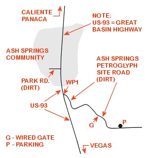
Continue on US-93 (Northerly) for 80.2 miles+- to an unmarked turnoff (on Right) for the Ash Springs Petroglyph Site Rd. (Dirt) and WP1.
Note 1: WP1 lies 0.10 miles+- Southerly of the intersection of US-93 and Park Rd. (see map below).
Note 2: the Ash Springs Petroglyph Site Rd. (local name - does not appear on most maps) is "typically" graded (may be unsuitable for low clearance vehicles - use your own discretion).
From WP1 on Northbound US-93 turn Right (Easterly) onto Ash Springs Petroglyph Site Rd. (essentially a U-turn) traveling Southerly, Easterly then Southeasterly (follow the more traveled path) for 0.21 miles+- to a "Wire Gate" blocking the road and waypoint "G".
Note 3: open the gate, drive thru and close it behind you - if open proceed and leave open.
From waypoint "G" continue Southeasterly then Easterly on Ash Springs Petroglyph Site Rd. for 0.12 miles+- to the Ash Springs Petroglyph Site parking area (waypoint "P").
Return by reversing route.
Approx. 106 miles from central Vegas Strip to the Ash Springs Petroglyph Site Trailhead.
..........
Driving Note:
With numerous "side roads" branching off of the Ash Springs Petroglyph Site Rd. "it is recommended" to utilize internet mapping resources such as aerial photography (not always current) and waypoint positions to visualize your route.
