Abandoned Vehicles
Various Locations
Section Index:
Overview:
The Mojave is the driest and one of the most famous deserts in the United States, if not the world.
Home to outstanding vistas, majestic mountain ranges, desert flats, a diversity of wildlife, approx. 2,000 plant species and wide open spaces, the Mojave also houses "hidden gems" just waiting to be discovered.
Of these most people would think of the deserts amazing geology, archaeological record, rich history, ghost towns and former mining sites (to name a few): all of which are located within a harsh and unforgiving environment.
For your author, there is nothing better than stumbling upon a "hidden gem" especially if that gem is a vintage automobile.
These vehicles, likely sitting for decades in the hot desert sun are rusted and missing the majority of their body parts, often resembling a piece of art rather than a decaying heap of metal.
When stumbling upon these "ancient" artifacts many questions come to mind:
• What model and year of vehicle is it?
• How did it get here?
• Whats its story?
• Who owned it?
• Why was it left to disintegrate into nothing?
Artifacts from the past often have the ability to tell interesting and inspiring stories, or at least make us wonder about their history.
Although vehicles such as these have been abandoned, these "works of art" can be as beautiful (in their own way) as they once were decades ago.
Sadly we may never know the how or why, but thankfully we can appreciate their "unique" beauty and captivating nature.
This ever expanding collection of abandoned vehicles is more about the "oddities" one can discover while exploring the uniqueness of the Mojave Desert.
Most entries on this web-page will include "information" for those individuals who wish to visit these locations, please do not deface or remove anything from these sites.
Any discarded vehicles within junkyards or on urban streets etc. will not be included, only the "forgotten" beauties left alone in the desert wilderness will be presented here.
Thanks:
to my good friend Dennis for his
insights on vehicle identification
(based on photographic evidence)
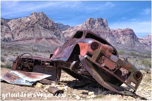
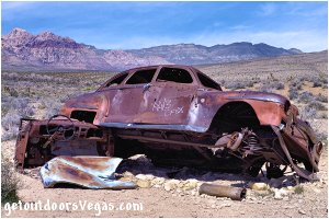
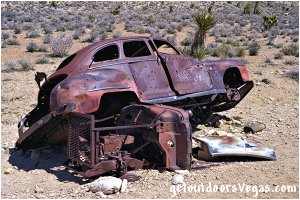
Dodge (1946-47) ↓ visited: 04/07/23
...location: Red Rock Canyon N.C.A.
Trail Directions:
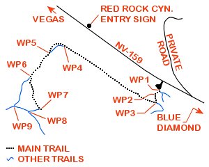
From the fence gate (WP1) at the Southeasterly corner of the Wheeler Camp Springs Parking Area pass thru the gate and immediately bear Right (Southwesterly) following a use-trail towards and into Red Rock Wash to WP2, being 0.04 miles+- distant of WP1.
From WP2 exit Red Rock Wash in a Southerly direction traveling 0.04 miles+- along the use-trail to a trail intersection and WP3.
From WP3 turn Right (Northwesterly) following an obvious trail for 0.59 miles+- to WP4.
Note: along this section (WP3-WP4) of the trail which often looks like a shallow wash there are many use-trails, stay on a path which parallels NV-159 (see map below).
From WP4 the trail arcs Southwesterly and runs alongside a small "unnamed" wash to WP5, being 0.11 miles+- distant of WP4.
From WP5 continue Southwesterly along the trail to a point where the aforementioned "unnamed" wash crosses the trail and WP6, being 0.12 miles+- distant of WP5.
From WP6 turn Left (Southerly) leaving the trail and follow the aforementioned "unnamed" wash upstream for 0.20 miles+- to the abandoned Dodge (1946-47) and WP7.
Return by reversing route.
Approx. out and back distance (as described above): 2.2 miles.
..........
From WP6 visitors can "utilize" a short loop while hiking to / from the abandoned Dodge (1946-47).
As summarized here (see map below) this "route alternative" can be "run" in either direction and if utilized as a true loop will only add 0.35 miles+- distance to this adventure.
• WP6-WP7 (follow wash): 0.20 miles+-
• WP7-WP8 (use-trail): 0.06 miles+-
• WP8-WP9 (trail): 0.09 miles+-
• WP9-WP6 (trail): 0.20 miles+-
..........
WP1: N36.05462 W115.41892
fence gate / trailhead
WP2: N36.05425 W115.41939
trail waypoint
WP3: N36.05361 W115.41928
trail intersection
WP4: N36.05798 W115.42814
trail waypoint
WP5: N36.05705 W115.42943
trail waypoint
WP6: N36.05570 W115.43076
trail waypoint
WP7: N36.05322 W115.42990
Dodge (1946-47)
WP8: N36.05294 W115.43095
trail intersection
WP9: N36.05340 W115.43239
trail intersection
Driving Directions:
From the I-15 (Las Vegas Fwy) interchange with W. Flamingo Rd. proceed South on I-15 for 4.5 miles+- to Exit #33.
Exit onto the Exit #33 offramp, traveling 0.4 miles+- (utilizing the right lane) and merge onto westbound Blue Diamond Rd. (NV-160).
Travel Westerly on Blue Diamond Rd. (NV-160) for 10.3 miles+- to the intersection of NV-160 and NV-159.
Turn Right (Northerly) onto NV-159 (aka Blue Diamond Rd.) traveling 3.8 miles+- to the unmarked Wheeler Camp Spring Parking Area (on your Left).
From NV-159 turn Left, crossing a cattle guard and enter into the Wheeler Camp Spring Parking Area (dirt).
Note: the Wheeler Camp Spring Parking Area lies 0.2 miles+- Northerly of a gravel haul road (private - gated) utilized by large trucks heading to a nearby Gypsum Mine (see map below).
Return by reversing route.
Approx. distance: 19 miles+- from central Vegas Strip to the Wheeler Camp Spring Parking Area and trailhead location (WP1).
Dodge (1946-47) ↑
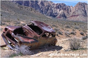
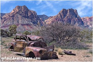
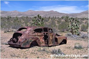
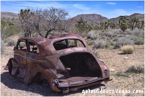
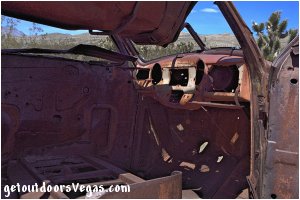
Chevy (1941) ↓ visited: 04/07/23
...location: Red Rock Canyon N.C.A.
Trail Directions:
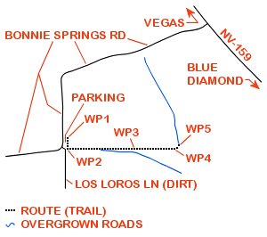
From the East edge of the dirt parking area (see driving directions below) locate an opening in the North-South right-of-way fenceline.
Proceed to the trailhead (WP1) just inside (East of) the fence opening.
Note: the "trail" beyond WP1 is in essence a cross-country route from this point forward, see the "note" in the Information / Tips section below.
From WP1 proceed South paralleling the fenceline to WP2, being 0.03 miles+- distant of WP1.
From WP2 travel East along a very faint and "overgrown" remnant of an "old road" for 0.18 miles+- to WP3.
Note: for observant hikers the abandoned Chevy (1941) is visible, being approx. 600 feet+- Easterly of WP3.
From WP3 continue East along the "old road" for 0.10 miles+- to a point where the road starts to curve Northeasterly and WP4.
From WP4 continue along the "old road" as it arcs in a Northeasterly direction for 0.01 miles+- to the abandoned Chevy (1941) and WP5.
Note: along the "old road" section of this route (WP2-WP3-WP4-WP5) the road itself is for the most part "barely visible" and hard to follow, requiring route finding and terrain awareness skills.
Therefore, hikers with less experience should consider traveling with a "qualified" person or group.
Return by reversing route.
Approx. out and back distance (as described above): 0.64 miles.
..........
WP1: N36.06155 W115.44198
trailhead
WP2: N36.06112 W115.44198
route waypoint
WP3: N36.06112 W115.43882
route waypoint
WP4: N36.06108 W115.43704
route waypoint
WP5: N36.06122 W115.43683
Chevy (1941)
Driving Directions:
From the I-15 (Las Vegas Fwy) interchange with W. Flamingo Rd. proceed South on I-15 for 4.5 miles+- to Exit #33.
Exit onto the Exit #33 offramp, traveling 0.4 miles+- (utilizing the right lane) and merge onto westbound Blue Diamond Rd. (NV-160).
Travel Westerly on Blue Diamond Rd. (NV-160) for 10.3 miles+- to the intersection of NV-160 and NV-159.
Turn Right (Northerly) onto NV-159 (aka Blue Diamond Rd.) traveling 5.0 miles+- to the intersection of NV-159 and Bonnie Springs Rd.
Note: the intersection of NV-159 and Bonnie Springs Rd. is unmarked, however a "tall wooden entry gate" (just off NV-159) marks its location.
Turn Left onto Bonnie Springs Rd. traveling Southwesterly then Southerly to a point just before Bonnie Springs Rd. turns Westerly again and the parking / trailhead area (WP1).
Note: the dirt trailhead parking area (wide shoulder) is located just off the left (East) edge of Bonnie Springs Rd. - being 0.6 miles+- distant of NV-159.
Return by reversing route.
Approximate distance: 21 miles+- from central Vegas Strip to the Chevy (1941) parking area and trailhead.
Chevy (1941) ↑
Ford (1949-50 - flatbed dually) ↓
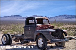
...location: Rhyolite, Nv. (visited: 06/10/21)
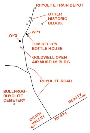
Note: For an abandoned vehicle, this truck seems to have a mind of its own.
Even though your author has not been to Rhyolite in a number of years it is apparent that this truck "moves" from time to time.
Utilizing Google Earth's™ aerial photography "historic imagery" capabilities it is evident that the trucks location within Rhyolite has moved at least two times in the last 2+ decades.
Prior to 07/2011 the truck is not visible anywhere in the Rhyolite area, possibly due to poor quality aerial photography imagery or it just wasn't there.
Around 07/2011 the truck appears at a point 175 feet+- Northwesterly (WP1) of the famous Tom Kelly's Bottle House where is "stood" for many years until it suddenly disappeared around 01/2020.
Studying the imagery the truck which up until 01/2020 had been at WP1 suddenly re-appeared at WP2 around 01/2020 at a location approx. 430 feet+- North-Northwesterly of the Goldwell Open Air Museum building.
The above image was captured on 06/10/2021 while the truck "rested" at WP2 and according to Google Earth's™ most recent imagery (01/2020) remains there to this day.
Seemingly a permanent "relic" of Rhyolite, this old Ford truck should be visible no matter where it pops up next: just keep an eye out for it.
For a vehicle with no engine and flat tires the question remains, who or what moved it and why.
Of course the town of Rhyolite being a ghost town might have something to do with the mysterious movements of this "ghost" truck, who really knows.
Therefore, the obvious question is: Where will the truck turn up next?
..........
WP1: N36.89771 W116.82951
Ford truck location (07/2011)
WP2: N36.89605 W116.83102
Ford truck location (01/2020)
Driving Directions:
From the intersection of US-95 and NV-374 in downtown Beatty, Nv. head Southwest on NV-374 for 4.0 miles to the turnoff for Rhyolite Road (paved).
Turn Northwesterly (right) up Rhyolite Road traveling 1.1 miles to the Goldwell Open Air Museum entrance.
Continue 0.2 miles+- North on Rhyolite Road (past the Goldwell Open Air Museum entrance) to a gravel parking area for WP2 (on Left) located midway thru a sweeping right-hand curve on Rhyolite Road.
Note: within this area are a group of old buildings and associated rubble, walk between these buildings (along an old road) in a Southwesterly direction for 180 feet+- to WP2 (most current "known" location of Ford truck).
From the gravel parking area for WP2 continue in a Northerly direction along the Rhyolite Road for 0.1 miles+- and turn Easterly (right) into the gravel parking area (a sign marks the turnoff) for Tom Kelly's Bottle House.
The "historic" location of the Ford truck (WP1) lies 175 feet+- Northwesterly of the "historic" bottle house and if present will be clearly visible.
Note: the Rhyolite area is "wide open" with unobstructed views in every direction, therefore if the truck is not at the aforementioned locations look for it elsewhere, if still around it should be easy to see.
Note: this Ford truck is only one of many things to see in Rhyolite. an area with lots of history and plenty of things to explore.
Approx. 126 miles from central Vegas Strip via I-15 (North), US-95 (North), NV-374 (West) and Rhyolite Road to historic Rhyolite, Nv.
Ford (1949-50 - flatbed dually) ↑
Dodge PU (1950) ↓ visited: 09/08/23
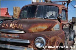
Breaking this web-page's rules about "abandoned vehicles" your author could not in good faith leave this really nice Dodge PU off "the list".
Sitting in a "semi-rural" area, most likely as a keepsake by it's owners, it is abandoned but only in the sense of not being driven.
In "pristine" condition, relative to other vehicles on this web-page, this Pickup is a work of art and seems to have a story to tell.
First and foremost (see image above) this Dodge PU was (at one time) a Mail Truck and is also "setup" as a Tow Truck: one can only imagine what this old Pickup "has seen".
Due to it's location, motorists traveling from the Los Angeles area to Las Vegas (or vise versa) would be more likely "to visit" this historic vehicle.
However, being just over an hour from Las Vegas, the Pickup's location is well within "easy reach" for interested parties staying in or passing thru the Vegas area.
Note: driving along I-15 from just South of Las Vegas to Baker, CA (and vise versa) is a very scenic and somewhat lonely (except for other motorists) experience, with wide open spaces, mountain views, the majestic Joshua Tree and "maybe" a few wild horses and burro to see along the way.
Driving Directions (from Las Vegas, NV):
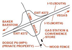
From the I-15 (Las Vegas Fwy) interchange with W. Flamingo Rd. proceed South on I-15 (into California) for a total distance of 61.7 miles+- to the interchange of I-15 and Cima Road (Exit #272).
Take the Exit #272 off-ramp and continue 0.2 miles+- to Cima Road.
Turn Southeasterly (Left) onto Cima Road traveling (over the freeway) a total distance of 0.4 miles+- to a gas station / convenience store (on your Left).
Approx. 62.3 miles from central Vegas Strip to the Dodge PU (WP1) on Cima Road.
..........
Driving Directions (from Baker, CA):
From the I-15 interchange (Exit #246) with CA-127 proceed North on I-15 for 25.8 miles+- to the interchange of I-15 and Cima Road (Exit #272).
Take the Exit #272 off-ramp and continue 0.2 miles+- to Cima Road.
Turn Southeasterly (Right) onto Cima Road traveling less than 0.1 miles to a gas station / convenience store (on your Left).
Approx. 26.1 miles from Baker, CA to the Dodge PU (WP1) on Cima Road.
..........
Note: when facing the gas station / convenience store (as seen from Cima Road), the Dodge PU (WP1) lies just South (to the Right) of the wooden fence that defines the store's Southerly property line and immediately East of Cima Road.
The Dodge PU is located on "private property" and is clearly visible from the shoulder of Cima Road: make sure to "watch for traffic" and Do Not Step onto Private Property
..........
WP1: N35.44083 W115.67320
Dodge PU (1950)
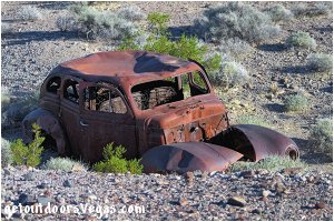
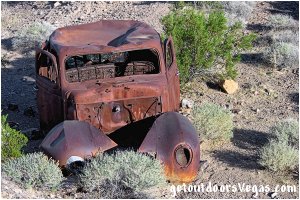
Dodge (1939 - Luxury Liner) ↓ visited: 10/26/23
...location: near Shoshone, Ca.
Trail Directions:
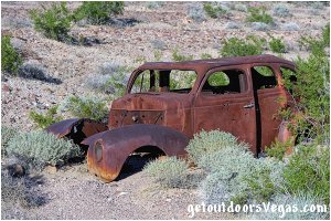
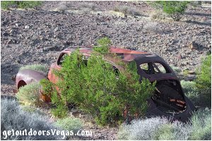
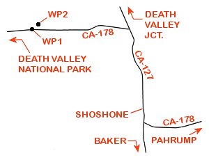
There is NO TRAIL to the Dodge 1939 - Luxury Liner: therefore from WP1 located on the North edge of CA-178 (aka Jubilee Pass Rd) proceed cross-country in a Northeasterly direction for 690 feet+- to the vehicle's position and WP2.
Note: lying in a shallow wash the Dodge Luxury Liner is not visible from anywhere along CA-178, once in the immediate vicinity of WP2 it is easily spotted.
Return to your vehicle by retracing your steps or proceed due South for approx. 450 feet to CA-178, thence Westerly to your vehicle.
..........
WP1: N35.99614 W116.30505
waypoint on north edge CA-178
WP2: N35.99735 W116.30327
Dodge 1939 - Luxury Liner
Driving Directions:
From the intersection of CA-178 and CA-127 located just South of "downtown" Shoshone, CA proceed North (towards Death Valley Jct) on CA-127 for 1.7 miles+- to the intersection of CA-127 and CA-178 (Jubilee Pass Rd).
Turn Left (Westerly) onto CA-178 (Jubilee Pass Rd) traveling 1.7 miles+- (towards Death Valley N.P.) to a waypoint (WP1) located on the North edge of CA-178.
Approx. 87.7 miles from central Vegas Strip via Pahrump, NV and Shoshone, CA to WP1 on CA-178 (Jubilee Pass Rd).
Dodge (1939 - Luxury Liner) ↑
Information / Tips:
Bring plenty of water / snacks, hat, sunscreen, sunglasses and hiking boots (recommended).
Make sure you have a full tank of gas and a fully pressurized spare tire.
• DON'T forget your camera
• Dogs may not be allowed
• Limited shade (typical)
• Water Not Available (typical)
..........
Note:
These adventures utilize "historic" roads, "conventional" trails, use-trails and cross-country travel.
Use-trails are sporadic in nature and often "venture out" in all directions which can make things "somewhat" confusing.
Therefore, it is recommended to utilize internet mapping resources such as aerial photography (not always current) and the provided waypoint positions to visualize your route prior to visiting any of these areas.
Following the individual trail directions (as described above), hikers with a map can more or less track their position (include aerial photography).
The use of a handheld GPS unit is suggested for many of these locations, know your GPS device's settings and use.
See the section on desert travel for GPS Waypoint information.
All distances and waypoints are approximate.
..........
Of Interest: Nelson Ghost Town
(large collection of old vehicles near Vegas)
Warning:
These adventures involve travel to a relatively remote area, please refer to the section on desert travel for safety information.
• Be mindful of lightning / flash floods
• Watch for snakes
(especially around abandoned vehicles)
• AVOID THE AREA DURING EXTREME HEAT
• You are responsible for your own safety
